
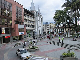
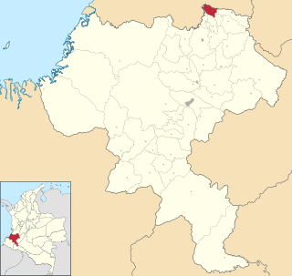
Cartago is a city in southwestern Colombia, about 187 miles (301 km) west of Bogotá. It is in the extreme northern portion of the Valle del Cauca Department. It is located very close to the city of Pereira, about a 20-minute drive. It is the sixth largest city in Valle after Cali, Palmira, Buenaventura, Tuluá and Jamundí. Per the 2018 Colombian census, Cartago's population was 118,803, a decrease from 121,741 per the Censo de Colombia de 2005.
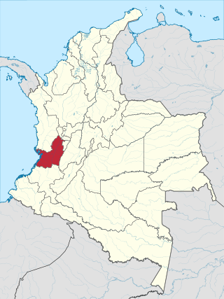
Valle del Cauca, or Cauca Valley, is a department in western Colombia abutting the Pacific Ocean. Its capital is Santiago de Cali. Other cities such as Buenaventura, Buga, Cartago, Palmira and Tuluá have great economical, political, social and cultural influence on the department's life. Valle del Cauca has the largest number of independent towns with over 100,000 inhabitants in the country, counting six within its borders. Buenaventura has the largest and busiest seaport in Colombia, moving about 8,500,000 tons of merchandise annually.

Armenia is the capital of Quindío Department in the South American country of Colombia. Armenia is a medium-sized city and part of the "coffee axis" along with Pereira and Manizales. It is one of the main centers of the national economy and of the Colombian coffee growing axis. As a result, the historic center of Armenia was named as part of the "Coffee Cultural Landscape" of UNESCO World Heritage Site in 2011.

Montenegro is a municipality in the western part of the department of Quindío, Colombia. It is located 10 km west of the departmental capital Armenia.

Pereira is the capital city of the Colombian department of Risaralda. It is located in the foothills of the Andes in a coffee-producing area of Colombia officially known as the "Coffee Axis". Pereira, alongside the rest of the Coffee Axis, form part of UNESCO World Heritage Site known as the "Coffee Cultural Landscape of Colombia". It is the most populated city in the Coffee Axis. Pereira is also part of the Central West Metropolitan Area, which has 709,322 residents and is composed of Pereira and the neighboring cities of Dosquebradas and La Virginia. It is considered the most important city in the "Coffee Axis" from a geopolitical and economic standpoint.

Santa Fe de Antioquia is a municipality in the Antioquia Department, Colombia. The city is located approximately 58 kilometres (36 mi) north of Medellín, the department capital. It has a population of approximately 23,000 inhabitants.

Bello is a city and municipality in Antioquia Department, Colombia and a suburb of Medellín, the department capital. Bello is part of The Metropolitan Area of the Aburrá Valley in the department of Antioquia. It is bordered on the north by the municipality of San Pedro de los Milagros, on the east by the municipality of Copacabana, on the south by the municipality of Medellín and on the west by the municipalities of Medellín and San Jerónimo.

Quimbaya is a town and municipality in the western part of the department of Quindío, Colombia. It is 20 km northwest of the departmental capital Armenia. The name of the city derives from the name of the Precolumbian culture that inhabited the area, the Quimbaya civilization. Located along the Colombian coffee growing axis, the municipality was made part of the "Coffee Cultural Landscape" UNESCO World Heritage Site in 2011.

Pijao is a municipality in the south-eastern part of the department of Quindío, Colombia. The township is located 31 km south of the departmental capital Armenia.

Salento is a town and municipality in the north-east of the department of Quindío, Colombia. The municipality covers an area of 377.67 km2. It was the first settlement in Quindío of the modern era, and the first municipality founded in the department. The town of Salento itself is located 24 km northeast of the departmental capital Armenia. In 2005 the municipality of Salento had an estimated population of 7247, of which 3597 lived in the main urban zone.
Calarcá is a municipality in the eastern part of the department of Quindío, Colombia. It is located 4 km east of the departmental capital Armenia. Its nickname is La Villa del Cacique in homage of its writers. The city was founded in 1886 by Segundo Henao during the time of colonization by people from Antioquia Department. It is the second city in Quindío with major quantity of inhabitants. In 2016 it had an estimated population of 78,779, of which 59,986 live in the main urban zone. Located along the Colombian coffee growing axis, it was made part of the "Coffee Cultural Landscape" UNESCO World Heritage Site in 2011.
Filandia is a town and municipality in the northern part of the department of Quindío, Colombia. It is located on the west side of Cordillera Central of the Andes mountain range running through central Colombia, 26 km north of the departmental capital Armenia. It is the northernmost of twelve municipalities that form Quindío, the second smallest department of Colombia. It houses a small community economically supported by agriculture and tourism.

The Colombian coffee region, also known as the Coffee Triangle is a part of the Paisa region in the rural area of Colombia. It is famous for growing and producing the majority of Colombian coffee. There are four departments in the area: Caldas, Quindío, Risaralda and the north municipalities of Tolima and Valle del Cauca. The most visited cities are Manizales, Armenia, Pereira, and Ibagué.

San José del Palmar is a municipality and town in the Chocó Department, Colombia in the central part of the country, 240 km west of the capital Bogotá. San José del Palmar is 1,288 meters above sea level and the population is about 4,800.

Aguadas is a town and municipality in the Colombian department of Caldas. It is bordered to the north by Abejorral, to the east by Sonsón, to the southeast by Salamina, to the south by Pacora, to the west by Caramanta and Valparaiso, and to the northwest by La Pintada. The municipality of Aguadas, located in the northern part of the department, was founded in 1808 by José Narciso Estrada. In addition to the fame of Aguadeño hats, which are very similar to palm-straw Panama hats. Aguadas offers visitors its historic center, which was declared a national monument in 1982. It has a temperate climate thanks to the variety of climates ranging from warm to moor.

Pácora is a town and municipality in the Colombian Department of Caldas. It is located in northern Caldas-Department, on the slopes of the Andes Central Mountains of the Republic of Colombia. With an average annual temperature of 18 °C, the town is bordered to the northeast with Aguadas, Caldas, to the south with Salamina, Caldas and La Merced, and to the west separated by the Cauca River, Marmato-Caldas and Caramanta-Antioquia department. The villages in Pácora are San Bartolomé, Castilla, Las Coles, Los Morros, San Lorenzo and Buenos Aires.

Palestina is a town in the south central region of the state of Caldas, Colombia. Located in the Triangle of Coffee Area, with a culture and tradition related to the colonization of Antioquia and the coffee growing. Because of this, the historic center of the town and surrounding rural areas were named part of the "Coffee Cultural Landscape" UNESCO World Heritage Site in 2011.
Puerto Tejada is a town and municipality in the Cauca Department, Colombia.

The Valle del Cauca Deputies hostage crisis refers to the kidnapping of 12 Deputies of the Assembly of Valle del Cauca, Colombia, on April 12, 2002 by members of the Revolutionary Armed Forces of Colombia (FARC) to pressure a prisoner exchange between them and the government and to negotiate the demilitarization of the municipalities of Florida and Pradera to initiate peace dialogues.

Yotoco is a town and municipality located in the Department of Valle del Cauca, Colombia.


