Tunas is an unincorporated community in northern Dallas County, Missouri, United States. It lies fourteen miles north of Buffalo on Route 73 and approximately seven miles east of Urbana on Route D. The town is located on Route 73, just southwest of the Little Niangua River. Tunas is part of the Springfield, Missouri Metropolitan Statistical Area.

Windyville is an unincorporated community in Dallas County, Missouri, United States. It is located approximately ten miles northeast of Buffalo along Missouri routes K and MM. The Niangua River flows past to the south and east of the community. It is part of the Springfield, Missouri Metropolitan Statistical Area.
Only is an unincorporated community in southwest Camden County, in the U.S. state of Missouri. The community was located on Missouri Route O about 3.5 miles south-southeast of Macks Creek and about 1.5 miles north of the Camden-Dallas county line. The location is on the Niangua Hills three miles west of the Niangua River.
Corkery is an extinct town in Dallas and Laclede counties, in the U.S. state of Missouri. The GNIS classifies it as a populated place. The community area is located on a ridge surrounded on three sides by an entrenched meander of the Niangua River which is about 300 feet below the ridgetop. The location is only accessible by road from Laclede County.
Foose is an unincorporated community in western Dallas County, in the U.S. state of Missouri. The community lies on Missouri Route EE just west of U.S. Route 65 about seven miles south-southwest of Buffalo. The Dallas-Polk county line is two miles west along Route EE. The community is at an elevation of 1207 feet and Greasy Creek, a tributary of the Niangua River, drains the area to the east of Route 65.
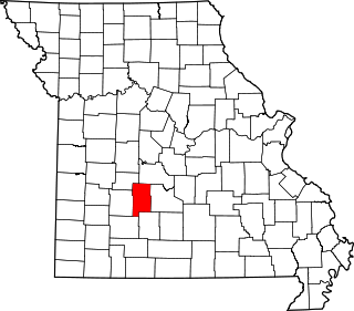
Handley is an unincorporated community in Dallas County, in the U.S. state of Missouri.
Hico is an extinct town in Dallas County, in the U.S. state of Missouri. The community was located adjacent to the Niangua River, approximately two miles northeast of Spring Grove and six miles southeast of Buffalo. The Hico Bridge over the Niangua on County Road JJ-203 is approximately 1000 feet west of the Hico location.
Leadmine is an unincorporated community in northern Dallas County, in the U.S. state of Missouri. The community is located about 3.5 miles east of Tunas on Missouri Route E. The Lead Mines Conservation Area lies one half mile to the east. It is approximantly 50 miles north-northeast of Springfield.
March is an unincorporated community in southeast Dallas County, in the U.S. state of Missouri. The community is located at the intersection of Missouri routes 38 and F.
Plad is an unincorporated community in Dallas County, in the U.S. state of Missouri.
Spring Grove is an unincorporated community in Dallas County, in the U.S. state of Missouri. The community is situated on Missouri Route H and the Niangua River flows past, about 1.5 miles to the east. Buffalo is approximately six miles to the north-northwest.
Thorpe is an unincorporated community in Dallas County, in the U.S. state of Missouri. The community lies just north of the Dallas-Webster county line, with Missouri Route W and the Niangua River passing about one mile to the east. The community lies approximately midway between Buffalo, eleven miles to the northwest and Marshfield, eleven miles to the southeast.
Tilden is an unincorporated community in Dallas County, in the U.S. state of Missouri.
Prior is an unincorporated community in Douglas County, Missouri. The community is located on Missouri Route 95 just north of the intersection with Missouri Route 76 and 2.5 miles north of Vanzant. The community sits on a ridge between Fox Creek to the west and Clifty Creek to the east at an elevation of 1,243 ft (379 m).
Oakland is an unincorporated community in Laclede County, in the Ozarks of southern Missouri. The community is located on Route B two miles south of the junction of Route B with Missouri Route 32. The site lies five miles southeast of Lebanon.
Shady Grove is an unincorporated community in Pulaski County, in the U.S. state of Missouri.
Fowler is an unincorporated community in southwest Texas County, in the U.S. state of Missouri.
Plum Valley is an extinct town in west central Texas County, in the U.S. state of Missouri. The GNIS classifies it as a populated place. The community lies near the East Fork of Roubidoux Creek about one mile west of Missouri Route 17 and 3.5 miles west of Bucyrus.
New Grove is an extinct town in western Wright County, in the Ozarks of southern Missouri. The GNIS classifies it as a populated place.
Dawson is an unincorporated community in eastern Wright County, Missouri. Dawson is located on Missouri Route 95 about nine miles north of Mountain Grove and three miles south of the Route 95 - Missouri Route 38 junction.