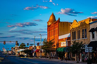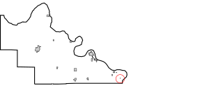
Okmulgee County is a county in the U.S. state of Oklahoma. As of the 2020 census, the population was 36,706. The county seat is Okmulgee. Located within the Muscogee Nation Reservation, the county was created at statehood in 1907. The name Okmulgee is derived from the Hitchita word okimulgi, meaning "boiling waters".

McIntosh County is a county located in the U.S. state of Oklahoma. As of the 2020 census, the population was 18,941. Its county seat is Eufaula. The county is named for an influential Muscogee Creek family, whose members led the migration of the Lower Towns to Indian Territory and served as leaders for generations.

Christie is a census-designated place (CDP) in Adair County, Oklahoma, United States. The population was 218 at the 2010 census, a 31.3 percent increase over the figure of 166 recorded in 2000.

Dry Creek is an unincorporated community and census-designated place (CDP) in Cherokee County, Oklahoma, United States. The population was 227 at the 2010 census.

Shady Grove is an unincorporated community and census-designated place (CDP) in Cherokee County, Oklahoma, United States. The population was 556 at the 2010 census. This is not to be confused with the similarly-named Shady Grove in McIntosh County, or the Shady Grove in Pawnee County.

Welling is an unincorporated community and census-designated place (CDP) in Cherokee County, Oklahoma, United States. The population was 771 at the 2010 census, an increase of 15.25 percent over the figure of 669 recorded in 2000. It is home to The Salvation Army's Heart o' Hills camp and conference center.
Copeland is an unincorporated community and census-designated place (CDP) in Delaware County, Oklahoma, United States. The population was 1,629 at the 2010 census, a 12.5 percent increase from the figure of 1,448 recorded in 2000. Founded as a railroad community, it was named for local resident D.R. Copeland.

Dennis is an unincorporated community and census-designated place (CDP) in Delaware County, Oklahoma, near Grand Lake. The population was 195 at the 2010 census. The Dennis Post Office existed from March 25, 1914, until January 31, 1956. It is said to be named for a local resident, Peter Dennis.
Tagg Flats is a census-designated place (CDP) in Delaware County, Oklahoma, United States. The population was 13 at the 2010 census.

Checotah is a town in McIntosh County, Oklahoma, United States. It was named for Samuel Checote, the first chief of the Creek Nation elected after the Civil War. Its population was 3,481 at the 2000 census. According to Census 2010, the population has decreased to 3,335; a 4.19% loss.
Duchess Landing is a census-designated place (CDP) in McIntosh County, Oklahoma, United States. The population was 95 at the 2000 census.

Eufaula is a city and county seat of McIntosh County, Oklahoma, United States. The population was 2,813 at the 2010 census, an increase of 6.6 percent from 2,639 in 2000. Eufaula is in the southern part of the county, 30 miles (48 km) north of McAlester and 32 miles (51 km) south of Muskogee.

Hitchita is a town in McIntosh County, Oklahoma, United States. The Encyclopedia of Oklahoma History and Culture says that the town was named for a band of Muskhogean Indians that had been absorbed into the Creek tribe. The population was 88 at the 2010 census, a decline of 22.1 percent from 113 in 2000.
Texanna is a census-designated place (CDP) in McIntosh County, Oklahoma, United States. The population was 2,083 at the 2000 census.
Sour John is a census-designated place (CDP) in Muskogee County, Oklahoma, United States. The population was 61 at the 2000 census.

Shady Grove was a town in southeastern Pawnee County, Oklahoma, United States, near Lake Keystone. The population was 44 at the 2000 census. In the 2010 census, its population had dropped to 2, and a 2011 news report stated that one of those two had left since the census, leaving it the smallest town in the state. The report explained that the owner of the seven mobile home lots that made up the town had incorporated it in 1997 to avoid being absorbed into a larger municipality, but had dissolved the town in 2006 and died in 2009, and nearly all the tenants had departed. This is not to be confused with the similarly-named Shady Grove in Cherokee County, or the Shady Grove in McIntosh County.
Short is a census-designated place (CDP) in Sequoyah County, Oklahoma, United States. It is part of the Fort Smith, Arkansas-Oklahoma Metropolitan Statistical Area. The population was 328 at the 2000 census.

Shady Hollow is a census-designated place (CDP) in southwestern Travis County, Texas, United States, and is partially in the City of Austin. It is located ten miles (16 km) southwest of Downtown Austin, near the Travis/Hays county line. The population was 5,004 at the 2010 census.

Beaver is a census-designated place (C.D.P.) in Raleigh County, West Virginia, United States. The population was 1,308 at the 2010 census.

Shady Spring is a census-designated place (CDP) in Raleigh County, West Virginia, United States. The population was 2,998 at the 2010 census. It is a residential community, with a low crime rate.


