
Mullingar is the county town of County Westmeath in Ireland. It is the third most populous town in the Midland Region, with a population of 20,928 in the 2016 census.

Tyrrellspass is a Georgian village in County Westmeath, Ireland. It is 81 kilometres (50 mi) from Dublin, in the south of the county on the R446 road. Tyrrellspass won the Irish Tidy Towns Competition in 1969. As of the census in April 2016, the population of Tyrrellspass was 483.

Edgeworthstown or Mostrim is a small town in County Longford, Ireland. The town is in the east of the county, near the border with County Westmeath. Nearby towns are Longford 12 km to the west, Mullingar 26 km to the east, Athlone 40 km to the south and Cavan 42 km to the north.
Raharney is a village in east County Westmeath, Ireland. It has a population of 221 according to the 2016 census.

Rosemount, historically called Ballybrickoge, is a village in County Westmeath, Ireland. It is located 5 km northeast of the town of Moate.
The Westmeath Senior Football Championship is an annual Gaelic Athletic Association competition organised by Westmeath GAA between the top Gaelic football clubs in County Westmeath. The winner of the Westmeath Championship qualifies to represent the county in the Leinster Senior Club Football Championship, the winner of which progresses to the All-Ireland Senior Club Football Championship. The current champions are The Downs GAA, winning their 10th title in 2022.
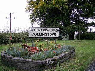
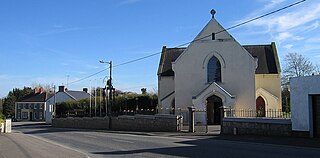
Collinstown is a village in north County Westmeath, situated on the R395 regional road overlooking Lough Lene. It lies 18 km (11 mi) northeast of the county town of Mullingar and had a population of 356.

Castletown Geoghegan is a village in County Westmeath, Ireland, and lies south west of Lough Ennell near the county town of Mullingar. Castletown was the seat of the Geoghegan family of the medieval Barony of Moycashel in County Westmeath.

Taghmaconnell or Taughmaconnell is a small village in County Roscommon, Ireland. It lies between Athlone and Ballinasloe. It is also the name of the parish in which the village lies.

Multyfarnham or Multyfarnam is a village in County Westmeath, Ireland.
Athlone GAA is the Gaelic football club in the town of Athlone in County Westmeath, Republic of Ireland. The local hurling club is called Southern Gaels.

Walsh Island or Walshisland is a village in County Offaly, Ireland. It takes its name from the surrounding hinterland which is a fertile area of land on a hill (104m) located in an area of bogland known as the Bog of Allen,. The village is one kilometre west of the R400 regional road which runs through the bog below. Walsh Island is 12 km from the nearest town, Portarlington. As of the 2016 census, the village had a population of 443 people.
Milltownpass is a village in County Westmeath, Ireland. It is located in the south of the county on the R446 regional road. The old route was replaced by a dual-carriageway from Kinnegad to Tyrrellspass in 2006, bypassing the village. Milltownpass is the second largest village in the parish of Rochfortbridge. It was one of the first villages in Ireland to have its own electricity supply: a mill on the Milltown River providing power to the village long before rural electrification.

Crookedwood is a small village in County Westmeath on the R394 regional road. Historically it was called Taghmon, after the townland it occupies.

Ballymore is a village in County Westmeath, Ireland, on the R390 road between Athlone and Mullingar. The historic Hill of Uisneach is nearby. The village was known in medieval times as the medieval borough of Ballymore Lough Sewdy, or Loughsewdy, after the nearby lake, the site of an ancient bruighean, or hostel.

Mount Temple is a village in County Westmeath in Ireland, about 6.5 km northwest of Moate. It is noted for its golf course of the same name. It was historically called Ballyloughloe. Mount Temple and its 'sister' village, Baylin, form the only two in the parish of Ballyloughloe.

Tubberclare or Tubberclair is a village and townland in County Westmeath, Ireland, between Ballymahon and Athlone. It lies 9 km (6 mi) from Athlone, on the N55 national secondary road, and 2 km (1 mi) north of Glasson. Toberclare is the official spelling of the name in English.

Brideswell is a village located in the south of County Roscommon, Ireland. It lies 11km from the Centre of Athlone and 60km from Tuam Town.

Castledaly is a village and electoral district in County Westmeath, Ireland. It is located on the R444 regional road 5 km southwest of the town of Moate and about 13km from Athlone.
Louaghnavalley or Loughnavally is a village in County Westmeath, Ireland. It is located at the crossroads of the R389 and the R390, to the west of Mullingar.


