
Mount Shasta is a potentially active volcano at the southern end of the Cascade Range in Siskiyou County, California. At an elevation of 14,179 feet, it is the second-highest peak in the Cascades and the fifth-highest in the state. Mount Shasta has an estimated volume of 85 cubic miles, which makes it the most voluminous stratovolcano in the Cascade Volcanic Arc. The mountain and surrounding area are part of the Shasta–Trinity National Forest.

Shasta County, officially the County of Shasta, is a county in the northern portion of the U.S. state of California. Its population is 182,155 as of the 2020 census, up from 177,223 from the 2010 census. The county seat is Redding.

Siskiyou County is a county in the northernmost part of the U.S. state of California. As of the 2020 census, the population was 44,076. Its county seat is Yreka and its highest point is Mount Shasta. It falls within the Cascadia bioregion.

Mount Shasta is a city in Siskiyou County, California, at about 3,600 feet (1,100 m) above sea level on the flanks of Mount Shasta, a prominent northern California landmark. The city is less than 9 miles (14 km) southwest of the summit of its namesake volcano. Its population is 3,223 as of the 2020 census, down from 3,394 from the 2010 census.

Shasta Dam is a concrete arch-gravity dam across the Sacramento River in Northern California in the United States. At 602 feet (183 m) high, it is the eighth-tallest dam in the United States. Located at the north end of the Sacramento Valley, Shasta Dam creates Shasta Lake for long-term water storage, flood control, hydroelectricity and protection against the intrusion of saline water. The largest reservoir in the state, Shasta Lake can hold about 4,500,000 acre-feet (5,600 GL).

The McCloud River is a 77.1-mile (124.1 km) long river that flows east of and parallel to the upper Sacramento River, in Siskiyou County and Shasta County in northern California in the United States. Protected under California's Wild and Scenic Rivers Act (1972), it drains a scenic mountainous area of the Cascade Range, including part of Mount Shasta. It is a tributary of the Pit River, which in turn flows into the Sacramento River. The three rivers join in Shasta Lake, formed by Shasta Dam north of Redding.

Shasta Lake, also popularly known as Lake Shasta, is a reservoir in Shasta County, California, United States. It began to store water in 1944 due to the impounding of the Sacramento River by Shasta Dam, the ninth tallest dam in the United States.
The Shastan peoples are a group of linguistically related indigenous peoples from the Klamath Mountains. They traditionally inhabited portions of several regional waterways, including the Klamath, Salmon, Sacramento and McCloud rivers. Shastan lands presently form portions of the Siskiyou, Klamath and Jackson counties. Scholars have generally divided the Shastan peoples into four languages, although arguments in favor of more or less existing have been made. Speakers of Shasta proper-Kahosadi, Konomihu, Okwanuchu, and Tlohomtah’hello "New River" Shasta resided in settlements typically near a water source. Their villages often had only either one or two families. Larger villages had more families and additional buildings utilised by the community.
Shasta McNasty is an American sitcom that aired on UPN from October 5, 1999 to August 1, 2000. The show was created by Jeff Eastin and produced by Eastin and Neal H. Moritz. The show starred Carmine Giovinazzo, Jake Busey, Dale Godboldo, and Jolie Jenkins.

The Trinity Mountains are a subrange of the Klamath Mountains, one of the ranges within the California Coast Ranges and part the greater Pacific Coast Ranges, the coastal mountain system extending from Mexico to Alaska. The Trinity Mountains subrange rises in Siskiyou County and eastern Trinity County, Northern California.

The Whiskeytown–Shasta–Trinity National Recreation Area is a United States National Recreation Area in northern California. The recreation area was authorized in 1965 by the United States Congress. Recreational activities available include swimming, fishing, boating, camping, and hiking.
KKLC is a radio station broadcasting a Contemporary Christian format. Licensed to Fall River Mills, California, United States. The station is currently owned by Educational Media Foundation.
Shasta is a census-designated place (CDP) in Shasta County, California, United States. Shasta sits at an elevation of 843 feet (257 m). Its population is 1,043 as of the 2020 census, down from 1,771 from the 2010 census.
The Big Bend Rancheria is a settlement of the Pit River Tribe (Achomawi) north of Big Bend, in Shasta County, California. It is about 50 miles (80 km) northeast of Redding.

Mount Eddy is the highest peak of the Trinity Mountains, a mountain range of the Klamath Mountains System, located in Siskiyou County, and Trinity County in northern California.

Gyokuko Carlson is a Soto Zen roshi and abbess of Dharma Rain Zen Center in Portland, Oregon, United States.

This is a list of the National Register of Historic Places listings in Shasta County, California.
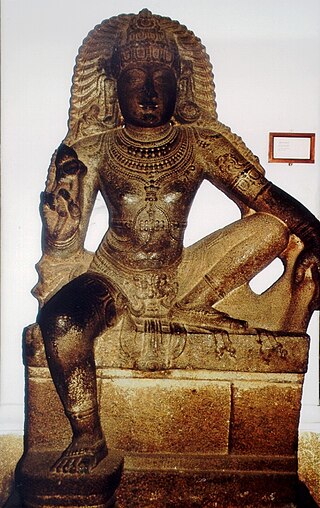
Shasta is a Hindu deity of Dravidian origin, usually associated with Shiva and Vishnu. In Hindu mythology, Shasta is considered to be another name of Ayyappan, described as the offspring of Shiva and Mohini. His principal function is to act as a kuladevata of a given clan, as well as act as a guardian of a village's boundaries. In South India, he is identified with the Ayyanar in Tamil Nadu and the Ayyappan in Kerala.
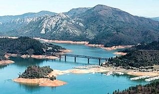
The Pit River Bridge is a double deck, deck truss, road and rail bridge over Shasta Lake in Shasta County, California. The bridge, carrying Interstate 5 on its upper deck and Union Pacific Railroad on its lower deck, was built in 1942 as part of the construction of the Shasta Dam/Shasta Lake reservoir system. The Pit River Bridge was constructed to replace the Lower Pit River Bridge, as the rising waters of the Shasta Lake reservoir would have put the older bridge underwater. The entire bridge spans 3,588 feet (1,094 m) long on the upper deck and 2,754 feet (839 m) on the lower deck. With a height of 500 feet (150 m) above the old Pit River bed, it is structurally the highest double decked bridge in the United States; however, today the bridge sits only about 40 feet (12 m) above the water when Shasta Lake is full. The bridge is Interstate 5's halfway point.
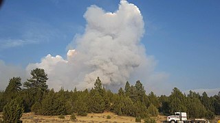
The Parker 2 Fire was a wildfire in the Modoc National Forest in Modoc County, California in the United States. The fire, which was reported on August 3, 2017, burned a total of 7,697 acres (31 km2). It was fully contained by August 28. The cause for the fire was lightning.

