
Victorian architecture is a series of architectural revival styles in the mid-to-late 19th century. Victorian refers to the reign of Queen Victoria (1837–1901), called the Victorian era, during which period the styles known as Victorian were used in construction. However, many elements of what is typically termed "Victorian" architecture did not become popular until later in Victoria's reign, roughly from 1850 and later. The styles often included interpretations and eclectic revivals of historic styles. The name represents the British and French custom of naming architectural styles for a reigning monarch. Within this naming and classification scheme, it followed Georgian architecture and later Regency architecture, and was succeeded by Edwardian architecture.
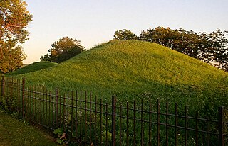
Dayton's Bluff is a neighborhood located on the east side of the Mississippi River in the southeast part of the city of Saint Paul, Minnesota which has a large residential district on the plateau extending backward from its top. The name of the bluff commemorates Lyman Dayton, for whom a city in Hennepin County was also named. On the edge of the southern and highest part of Dayton's bluff, in Indian Mounds Park, is a series of seven large aboriginal mounds, 4 to 18 feet high, that overlook the river and the central part of the city.

The city of Davenport, Iowa, United States has neighborhoods dating back to the 1840s. The Davenport Plan and Zoning Commission divided the city into five areas: downtown, central, east end, near north, and northwest and west end. The neighborhoods contain many architectural designs, including Victorian, Queen Anne, and Tudor Revival. Many of the original neighborhoods were first inhabited by German settlers.

The Sheffield Plain Historic District encompassing the original 18th-century village center of Sheffield, Massachusetts, United States. The linear district extends southward about 0.5 miles (0.80 km) from the junction of United States Route 7 and Cook Road, where the original town common is located. The district was primarily developed in the mid-18th and early 19th centuries. It was listed on the National Register of Historic Places in 1988.
Church Street Historic District is a historic district roughly on Church Street between Park Ave. and Highland St. in Ware, Massachusetts. This mainly residential area includes some of Ware's finest late 19th century houses and a well-preserved collection of Greek Revival houses. The area was developed primarily in response to the growth of industry to the south. The district was listed on the National Register of Historic Places in 1983.

The University-Cultural Center MRA is a pair of multiple property submissions to the National Register of Historic Places which were approved on April 29 and May 1, 1986. The structures included are all located in Midtown, near Woodward Avenue and Wayne State University in Detroit, Michigan. The two submissions are designated the University-Cultural Center MRA Phase I, containing five properties, and the University-Cultural Center MRA Phase II, containing three properties.

The Calumet Historic District is a National Historic Landmark District that encompasses most of the village of Calumet, Michigan. The district was designated in 1989 for the community's importance in the history of the region's copper mining industry.

The Riverview Terrace Historic District is a 15.2-acre (6.2 ha) historic district in Davenport, Iowa, United States, that was listed on the National Register of Historic Places in 1984. It was listed on the Davenport Register of Historic Properties in 1993. The neighborhood was originally named Burrow's Bluff and Lookout Park and contains a three-acre park on a large hill.
Old North Knoxville is a neighborhood in Knoxville, Tennessee, United States, located just north of the city's downtown area. Initially established as the town of North Knoxville in 1889, the area was a prominent suburb for Knoxville's upper middle and professional classes until the 1950s. After a period of decline, preservationists began restoring many of the neighborhood's houses in the 1980s. In 1992, over 400 houses and secondary structures in the neighborhood were added to the National Register of Historic Places as the Old North Knoxville Historic District.

College Square Historic District is a nationally recognized historic district located on a bluff north of downtown Davenport, Iowa, United States. It was listed on the National Register of Historic Places in 1983. The district derives it name from two different colleges that were located here in the 19th century.

The Hamburg Historic District is a residential neighborhood located on a bluff northwest of downtown Davenport, Iowa, United States. It is listed on the Davenport Register of Historic Properties and on the National Register of Historic Places. The historic district is where the city's middle and upper-income German community lived in the 19th and early 20th centuries. Germans were the largest ethnic group to settle in Davenport.

The Bridge Avenue Historic District is located in a residential neighborhood on the east side of Davenport, Iowa, United States. It has been listed on the National Register of Historic Places since 1983. The historic district stretches from River Drive along the Mississippi River up a bluff to East Ninth Street, which is near the top of the hill.

The Sherman Hill Historic District is located in Des Moines, Iowa, United States. It is one of the oldest residential suburbs in Des Moines. Single-family houses were constructed beginning around 1880 and multi-family dwellings were built between 1900 and 1920. The district encompasses 80 acres (0.32 km2) and 210 buildings and is bounded by 15th Street to the East, High Street to the South, Martin Luther King Parkway on the West, and School Street to the North. The historic district has been listed on the National Register of Historic Places since 1979.

The Fifth Street Bluff Historic District is a nationally recognized historic district located in Ottumwa, Iowa, United States. It was listed on the National Register of Historic Places in 1998. At the time of its nomination it contained 67 resources, which included 40 contributing buildings, three contributing structures, and 24 non-contributing buildings.
The Tuscumbia Historic District is a historic district in Tuscumbia, Alabama. The district contains 461 contributing properties and covers about 232 acres of the town's original area. The first white settlers in Tuscumbia built a village next to Big Spring, at the site of what is today Spring Park. Many settlers, many from Virginia and Maryland, began to emigrate to The Shoals in the 1820s and 1830s. The oldest houses in the district are Tidewater-type cottages, a style native to the Middle Atlantic. Also built during the town's early period are some of the oldest commercial buildings in Alabama, including the Morgan-Donilan Building and a seven-building block known as Commercial Row. The town's economy declined in the 1840s, when many farmers left seeking more fertile soil, through the Civil War and Reconstruction.

The Commerce Street Residential Historic District is a historic district in Greenville, Alabama. The district consists of four houses along Commerce Street, constructed between 1846 and 1895. They represent the final and last remaining residential construction on the town's main street.

The Main Street–College Street Historic District encompasses a historically fashionable residential area of Burlington, Vermont. Principally located along Main and College Streets between South Winooski and South Williams Streets, the area was one of the city's most exclusive residential areas from the early 19th century to the early 20th century, and includes a diversity of high quality architecture from that period. It was listed on the National Register of Historic Places in 1988.

The Boyne City Central Historic District is a commercial historic district located along the 100 and 200 blocks of Water and Lake Streets and adjacent parts of Main Street and South Park in Boyne City, Michigan. The district also contains the residential structures in the local Pearl Street Historic District to the east of the downtown area. It was listed in the National Register of Historic Places in 2012.

The North Milford Village Historic District is a historic district located in Milford, Michigan, including the commercial area along Main Street from the Huron River to Summit, industrial areas around the mill ponds west of Main, and residential areas east of Main. The district was listed on the National Register of Historic Places in 2000.

The Hegel Road Historic District is a mixed commercial and residential historic district located along Hegel Road between Seneca and the Goodrich Millpond in Goodrich, Michigan. It was listed on the National Register of Historic Places in 1982.


