
A conurbation is a region comprising a number of metropolises, cities, large towns, and other urban areas which through population growth and physical expansion, have merged to form one continuous urban or industrially developed area. In most cases, a conurbation is a polycentric urbanised area in which transportation has developed to link areas. They create a single urban labour market or travel to work area.

The West Midlands conurbation is the large conurbation in the West Midlands region of England. In the area they are multiple towns and two cities: the city of Birmingham with the towns of Solihull and Sutton Coldfield as well as an area called the Black Country including the city of Wolverhampton and the towns of Dudley, Walsall, Sandwell, Stourbridge and Halesowen.

The Metropolitan Borough of Rotherham is a metropolitan borough of South Yorkshire, England. It is named after its main settlement of Rotherham. The wider borough spans a larger area and covers the outlying towns of Maltby, Swinton, Wath-upon-Dearne, Dinnington. As well as the villages of Rawmarsh and Laughton. A large valley spans the entire borough and is referred to as the "Rother Valley".

The Nottingham Built-up Area (BUA), Nottingham Urban Area, or Greater Nottingham is an area of land defined by the Office for National Statistics as which is built upon, with nearby areas linked if within 200 metres - see the List of urban areas in the United Kingdom article for a broader definition. It consists of the city of Nottingham and the adjoining urban areas of Nottinghamshire and Derbyshire, in the East Midlands of England. It had a total population of 729,977 at the time of the 2011 census. This was an increase of almost 10% since the 2001 census recorded population of 666,358, due to population increases, reductions and several new sub-divisions.

Greater Glasgow is an urban settlement in Scotland consisting of all localities which are physically attached to the city of Glasgow, forming with it a single contiguous urban area. It does not relate to municipal government boundaries and its territorial extent is defined by the General Register Office for Scotland, which determines settlements in Scotland for census and statistical purposes. Greater Glasgow had a population of 1,199,629 at the time of the 2001 UK Census making it the largest urban area in Scotland and the fifth-largest in the United Kingdom. However, the population estimate for the Greater Glasgow 'settlement' in mid-2016 was 985,290 – the reduced figure explained by the removal of the Motherwell & Wishaw (124,790), Coatbridge & Airdrie (91,020) and Hamilton (83,730) settlement areas east of the city due to small gaps between the populated postcodes. The 'new towns' of Cumbernauld and East Kilbride (75,120) were never included in these figures despite their close ties to Glasgow due to having a clear geographical separation from the city. In the 2020 figures, the Greater Glasgow population had risen to just over 1 million.

South Hampshire is a term used mainly to refer to the conurbation formed by the city of Portsmouth, city of Southampton and the non-metropolitan boroughs of Gosport, Fareham, Havant and Eastleigh in southern Hampshire, South East England. The area was estimated to have a population of over 1.5 million in 2013. It is the most populated part of South East England excluding London. The area is sometimes referred to as Solent City particularly in relation to local devolution, but the term is controversial.

The Greater Manchester Built-up Area is an area of land defined by the Office for National Statistics (ONS), consisting of the large conurbation that encompasses the urban element of the city of Manchester and the metropolitan area that forms much of Greater Manchester in North West England. According to the United Kingdom Census 2011, the Greater Manchester Built-up Area has a population of 2,553,379 making it the second most populous conurbation in the United Kingdom after the Greater London Built-up Area. This was an increase of 14% from the population recorded at the United Kingdom Census 2001 of 2,240,230, when it was known as the Greater Manchester Urban Area.
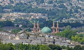
The West Yorkshire Built-up Area, previously known as the West Yorkshire Urban Area is a term used by the Office for National Statistics (ONS) to refer to a conurbation in West Yorkshire, England, based on the cities of Leeds, Bradford and Wakefield, and the large towns of Huddersfield and Halifax. It is the 4th largest urban area in the United Kingdom. However, it excludes other towns and villages such as Featherstone, Normanton, Castleford, Pontefract, Hemsworth, Todmorden, Hebden Bridge, Knottingley, Wetherby and Garforth which, though part of the county of West Yorkshire are considered independently. There are substantial areas of agricultural land within the designated area – more than in any other official urban area in England – many of the towns and cities are only just connected with one another by narrow outlying strips of development.
Greater Bristol is a term used for the conurbation which contains and surrounds the city of Bristol in the South West of England. There is no official "Greater Bristol" authority, but the term is sometimes used by local, regional and national authorities, and others as a synonym for either the "Bristol Urban Area" or a wider area of the former County of Avon, and by some, TfGB, to refer to the Province of Bristol as defined by C. B. Fawcett (1919) or Derek Senior (1969).
Farnborough/Aldershot built-up area and Aldershot Urban Area are names used by the ONS to refer to a conurbation spanning the borders of Surrey, Berkshire and Hampshire in England. The ONS found a population of 252,937 in 2011. This makes it the 29th-largest built-up area in England.
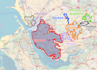
The Liverpool Built-up Area is a term used by the Office for National Statistics (ONS) to denote the urban area around Liverpool in England, to the east of the River Mersey. The contiguous built-up area extends beyond the area administered by Liverpool City Council into adjoining local authority areas, particularly parts of Sefton and Knowsley. As defined by ONS, the area extends as far east as St Helens, Haydock, and Ashton-in-Makerfield in Greater Manchester.
The Leicester Urban Area or Leicester Built Up Area is an urban agglomeration defined by the Office of National Statistics (ONS), centred on the City of Leicester in the English Midlands. With a population of 559,017 at the time of the 2021 census, increased from 508,916 at the time of the 2011 census, the Built Up Area is the eleventh largest in England and thirteenth largest in the United Kingdom. It comprises Leicester itself and its suburbs, all of which are contiguous with, or situated in close proximity to, the city.

The Wigan Urban Area is an area of land defined by the Office for National Statistics consisting of the built-up, or 'urbanised' area containing Wigan in Greater Manchester and Skelmersdale in West Lancashire.

The Brighton and Hove Built-up area or Brighton/Worthing/Littlehampton conurbation has a population of 474,485, making it England's 12th largest conurbation. This was an increase of around 3% from the 2001 population of 461,181. Named the Brighton/Worthing/Littlehampton conurbation by the Office for National Statistics for the 2001 census and Brighton and Hove Built-up area for the 2011 census, the area has also been known as Greater Brighton, although the Greater Brighton City Region that was created in 2014 from seven local authorities in Sussex covers a much larger area. The conurbation dominates West and East Sussex, with around one in three of Sussex's population living within its boundaries. It is also the second largest conurbation in the South East region of England and the second largest conurbation on the English Channel coast, in either England or France. In both of these cases the Brighton conurbation trails the Southampton and Portsmouth conurbation. The Brighton/Worthing/Littlehampton conurbation was the largest on the Channel before Portsmouth and Southampton's conurbations were combined for much official data analysis after the 2011 census.
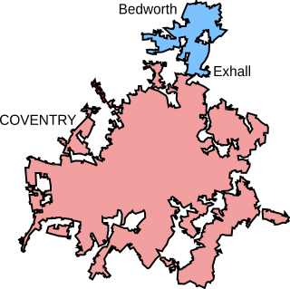
The Coventry/Bedworth Urban Area or Coventry Built-up area as defined by the Office for National Statistics had a population of 359,252 at the 2011 census, which made it the 16th largest conurbation in England and Wales by population. It is also one of the most densely populated. In the 2021 census the population of the urban area was recorded at 389,603.
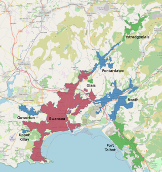
The Swansea Urban Area or Swansea Built-up Area is an area of land in south Wales, defined by the Office for National Statistics for population monitoring purposes. It is an urban conurbation and is not coterminous with the City and County of Swansea. It consists of the urban area centred on Swansea city centre; the Swansea Valley including Clydach, Ystradgynlais and Pontardawe; and includes Neath and Port Talbot which are outside the county boundaries, but excludes the urban area of Gorseinon within the county boundaries.

The Wrexham Built-up area is an area of land defined by the United Kingdom Office for National Statistics (ONS) for population monitoring purposes. It is an urban conurbation fully within Wrexham County Borough and consists of the urban area centred on the city of Wrexham and the historically industrial settlements to the west including Gwersyllt, Rhostyllen, Brymbo, Bradley and New Broughton.


