
America's first transcontinental railroad was a 1,911-mile (3,075 km) continuous railroad line built between 1863 and 1869 that connected the existing eastern U.S. rail network at Council Bluffs, Iowa, with the Pacific coast at the Oakland Long Wharf on San Francisco Bay. The rail line was built by three private companies over public lands provided by extensive U.S. land grants. Building was financed by both state and U.S. government subsidy bonds as well as by company-issued mortgage bonds. The Western Pacific Railroad Company built 132 miles (212 km) of track from the road's western terminus at Alameda/Oakland to Sacramento, California. The Central Pacific Railroad Company of California (CPRR) constructed 690 miles (1,110 km) east from Sacramento to Promontory Summit, Utah Territory. The Union Pacific Railroad (UPRR) built 1,085 miles (1,746 km) from the road's eastern terminus at the Missouri River settlements of Council Bluffs and Omaha, Nebraska, westward to Promontory Summit.

Carson County is a county located in the U.S. state of Texas. As of the 2020 census, its population was 5,807. The county seat is Panhandle. The county was founded in 1876 and later organized in 1888. It is named for Samuel Price Carson, the first secretary of state of the Republic of Texas.

Franklin is a city in Howard County, Missouri, United States. It is located along the Missouri River in the central part of the state. Located in a rural area, the city had a population of 70 at the 2020 census. It is part of the Columbia, Missouri Metropolitan Statistical Area.

Pawnee Rock, one of the most famous landmarks on the Santa Fe Trail, is located in Pawnee Rock State Park, just north of Pawnee Rock, Kansas, United States. Originally over 150 feet (46 m) tall, railroad construction stripped it of some 15 to 20 feet (6.1 m) in height for road bed material. A memorial monument, picnic area, and pergola have been constructed on the top. From the top of the pergola is a view the Arkansas river valley and the route of the Santa Fe trail. Today it is a prominence rising 50 or 60 feet above the surrounding plains. Matt Field, who traveled the Santa Fe Trail in 1840, later wrote, "Pawnee Rock springs like a huge wart from the carpeted green of the prairie." Traders, soldiers, and emigrants who stopped, carved their names into the brown sandstone. Some of these names are still visible among the markings of the more recent visitors.

The Atchison, Topeka and Santa Fe Railway, often referred to as the Santa Fe or AT&SF, was one of the largest Class 1 railroads in the United States.

The Santa Fe Trail was a 19th-century route through central North America that connected Franklin, Missouri, with Santa Fe, New Mexico. Pioneered in 1821 by William Becknell, who departed from the Boonslick region along the Missouri River, the trail served as a vital commercial highway until 1880, when the railroad arrived in Santa Fe. Santa Fe was near the end of El Camino Real de Tierra Adentro which carried trade from Mexico City. The trail was later incorporated into parts of the National Old Trails Road and U.S. Route 66.

Fort Larned National Historic Site preserves Fort Larned which operated from 1859 to 1878. It is approximately 5.5 miles (8.9 km) west of Larned, Kansas, United States.

Santa Fe Trail is a 1940 American Western film directed by Michael Curtiz and starring Errol Flynn as J. E. B. "Jeb" Stuart, Olivia de Havilland, Raymond Massey as John Brown, Ronald Reagan as George Armstrong Custer and Alan Hale. Written by Robert Buckner, the film is critical of the abolitionist John Brown and his controversial campaign against slavery before the American Civil War. In a subplot, Jeb Stuart and George Armstrong Custer—who are depicted as friends from the same West Point graduating class—compete for the hand of Kit Carson Holliday.

Cattle drives were a major economic activity in the 19th and early 20th century American West, particularly between 1850s and 1910s. In this period, 27 million cattle were driven from Texas to railheads in Kansas, for shipment to stockyards in St. Louis and points east, and direct to Chicago. The long distances covered, the need for periodic rests by riders and animals, and the establishment of railheads led to the development of "cow towns" across the frontier.

The Battle of Beecher Island, also known as the Battle of Arikaree Fork, was an armed conflict between elements of the United States Army and several of the Plains Native American tribes in September 1868. Beecher Island, on the Arikaree River, then known as part of the North Fork of the Republican River, near present-day Wray, Colorado, was named afterwards for Lieutenant Fredrick H. Beecher, an army officer killed during the battle.

Fort Harker, located in Kanopolis, Kansas, was an active military installation of the United States Army from November 17, 1866, to October 5, 1872. The fortification was named after General Charles Garrison Harker, who was killed in action at the Battle of Kennesaw Mountain in the American Civil War. Fort Harker replaced Fort Ellsworth, which had been located 1.6 km (0.99 mi) from the location of Fort Harker and was abandoned after the new fortifications at Fort Harker were constructed. Fort Harker was a major distribution point for all military points farther west and was one of the most important military stations west of the Missouri River.

Fort Hays, originally named Fort Fletcher, was a United States Army fort near Hays, Kansas. Active from 1865 to 1889 it was an important frontier post during the American Indian Wars of the late 19th century. Reopened as a historical park in 1929, it is now operated by the Kansas Historical Society as the Fort Hays State Historic Site.

Fort Lyon is an unincorporated community and U.S. Post Office in Bent County, Colorado, United States. The Fort Lyon Post Office had the ZIP Code 81038, though the zip code for nearby Las Animas (81054) is also used.

Old Cowtown Museum is an accredited history museum located in Wichita, Kansas, United States. It is located next to the Arkansas River in central Wichita. The Museum was established in 1952, and is one of the oldest open-air history museums in central United States with 54 historic and re-created buildings, including a period farm and out-buildings, situated on 23 acres of land off the original Chisholm Trail. Cowtown is a combination of attraction, museum, living history site, and historic preservation project. The Historic Wichita Cowtown, Inc. Board, a 501(c)(3) not-for-profit institution, works with the City of Wichita to further the Museum and its mission.

Boggsville is an extinct town located in Bent County, Colorado, United States. The town was located near the Purgatoire River about 3 miles (4.8 km) above the Purgatoire's confluence with the Arkansas River. It was established in 1866. The surviving structures are among the earliest examples of Territorial architecture in Colorado. Boggsville was the last home of frontiersman Kit Carson before his death in 1868 at Fort Lyon. The U.S. Post Office at Las Animas now serves Boggsville postal addresses.
In the history of the American frontier, pioneers built overland trails throughout the 19th century, especially between 1829 and 1870, as an alternative to sea and railroad transport. These immigrants began to settle much of North America west of the Great Plains as part of the mass overland migrations of the mid-19th century. Settlers emigrating from the eastern United States did so with various motives, among them religious persecution and economic incentives, to move from their homes to destinations further west via routes such as the Oregon, California, and Mormon Trails. After the end of the Mexican–American War in 1849, vast new American conquests again encouraged mass immigration. Legislation like the Donation Land Claim Act and significant events like the California Gold Rush further encouraged settlers to travel overland to the west.
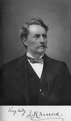
James R. Mead was a plainsman, Kansas pioneer, one of the founders of Wichita, Kansas and state legislator. He was active in seeking to protect the rights of the Kansas Indian tribes. He aided in directing the cattle drives along the Chisholm Trail to the city. In 1871, he was instrumental in bringing the Wichita & Southwestern Railroad to Wichita. He possessed a lifelong interest in biology and ethnology. Later in life, he wrote articles for the Kansas State Historical Society and for the Kansas Academy of Science. His memoirs were published in the book, Hunting and Trading on the Great Plains 1859-1875 [Rowfant Press 2008, ISBN 978-1-929731-07-7].

Waldeck is a ghost town in Marion County, Kansas, United States. It is currently a ghost town that was located approximately 3.5 miles north of Lehigh next to a railroad. No buildings remain of this former community.

Yocemento is an unincorporated community in Big Creek Township, Ellis County, Kansas, United States. The settlement lies across the banks of Big Creek against the base of bluffs capped by massive limestone blocks, in which lies the 20th-century origin of the community.


