
Thomas County is a county located in the U.S. state of Kansas. Its county seat is Colby. As of the 2020 census, the county population was 7,930. The county was named after George Thomas, a general during the American Civil War.

Morris County is a county located in the U.S. state of Kansas. Its county seat and largest city is Council Grove. As of the 2020 census, the county population was 5,386. The county was named for Thomas Morris, a U.S. Senator from Ohio and anti-slavery advocate.
Logan County is a county located in the U.S. state of Kansas. Its county seat and largest city is Oakley. As of the 2020 census, the county population was 2,762. The county was named for John Logan, a general during the American Civil War. One of the county's distinctive features is a mile-long stretch of Smoky Hill Chalk bluffs that tower 100 feet (30 m) high over the Smoky Hill River and are dubbed "Little Jerusalem" for resemblance to the ancient walled city. The formation is mostly on private land. In 2016, The Nature Conservancy purchased the property and the Little Jerusalem Badlands State Park opened to the public in October 2019.
Butler County is a county in the U.S. state of Kansas and is the largest county in the state by total area. Its county seat is El Dorado and its most populous city is Andover. As of the 2020 census, the county population was 67,380. The county was named for Andrew Butler, a U.S. Senator from South Carolina who coauthored the Kansas–Nebraska Act.

Ellis is a city in Ellis County, Kansas, United States. As of the 2020 census, the population of the city was 1,958.

Winona is a city in Logan County, Kansas, United States. As of the 2020 census, the population of the city was 193.

Lincolnville is a city in Marion County, Kansas, United States. As of the 2020 census, the population of the city was 168. It is located northeast of Marion, west of the intersection of U.S. Route 77 highway and 290th Street next to the Union Pacific Railroad.

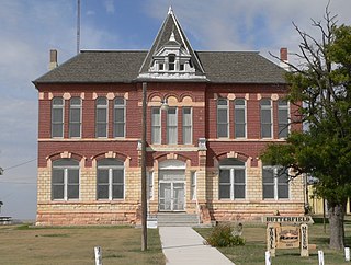
Peabody is a city in Marion County, Kansas, United States. It is named after F.H. Peabody of Boston, former vice-president of the Atchison, Topeka and Santa Fe Railway. Peabody is well known in the region for its Independence Day Celebration on July 4, and its historic 1880s downtown main street. As of the 2020 census, the population of the city was 937. It is located between Newton and Florence along U.S. Route 50 highway.

Hutchinson is the largest city and county seat in Reno County, Kansas, United States, and located on the Arkansas River. It has been home to salt mines since 1887, thus its nickname of "Salt City", but locals call it "Hutch". As of the 2020 census, the population of the city was 40,006.

Oakley is a city in Gove, Logan, and Thomas counties in the U.S. state of Kansas. It is the county seat of Logan County. As of the 2020 census, the population of the city was 2,046.

Carneiro is an unincorporated community in Ellsworth County, Kansas, United States. It is located approximately 10 miles (16 km) east of Ellsworth, north of Mushroom Rock State Park and Kanopolis Lake.

Walker is an unincorporated community in Herzog Township, Ellis County, Kansas, United States. It is located between Hays and Russell, along old Hwy 40 on the north side of I-70. Walker has a post office with ZIP code 67674.

Antelope is an unincorporated community in Marion County, Kansas, United States. Antelope got its name from antelope grazing near where the first school was being built. It is located northeast of Marion, about 0.9 miles west of the intersection of U.S. Route 77 highway and 250th Street along the Union Pacific Railroad.
Aulne is an unincorporated community in Marion County, Kansas, United States. The Aulne name was suggested by officials of the railroad when it was built through Aulne during the 19th century. It is located southwest of Marion at the intersection of Pawnee Road and 140th Street next to the Union Pacific Railroad.

Monument is an unincorporated community in northeast Logan County, Kansas, United States. As of the 2020 census, the population of the community and nearby areas was 56. It is located along U.S. Route 40 west of Oakley.
Homer is an unincorporated area in Russell County, Kansas, United States. It lies on the border between Grant and Russell Townships. There is no community or settlement at Homer.
Toulon is an unincorporated community in Big Creek Township, Ellis County, Kansas, United States. It is located east of Hays along old Hiway 40.

Seguin is an unincorporated community in Sheridan County, Kansas, United States. It is located in Logan Township, approximately 10 miles west of Hoxie. It lies south of U.S. Route 24, to which it is linked by Kansas Highway 188.
Studley is an unincorporated community in Sheridan County, Kansas, United States, approximately 16 miles east of Hoxie along U.S. Route 24. It is on the eastern edge of the county in Valley Township, bordering Graham County. It was named after the Studley Royal Park, in England.

Riga is an unincorporated community in Trego County, Kansas, United States.


