Sherrard, Illinois

Last updated

Sherrard, Illinois
The Sherrard Bank.JPG
Mercer County Illinois Incorporated and Unincorporated areas Sherrard Highlighted.svg
Location in Mercer County, Illinois
Usa edcp location map.svg
Red pog.svg
Sherrard
Location in the United States
Coordinates: 41°19′6″N90°30′19″W / 41.31833°N 90.50528°W / 41.31833; -90.50528
CountryUnited States
StateIllinois
County Mercer
Township Richland Grove
Area
[1]
  Total1.16 sq mi (3.00 km2)
  Land0.93 sq mi (2.40 km2)
  Water0.23 sq mi (0.60 km2)
Elevation
805 ft (245 m)
Population
 (2020) [2]
  Total692
  Density745.69/sq mi (288.00/km2)
Time zone UTC-6 (CST)
  Summer (DST) UTC-5 (CDT)
ZIP code
61281
Area code 309
FIPS code 17-69368
Wikimedia CommonsSherrard, Illinois

Sherrard is a village in Mercer County, Illinois, United States. The population was 692 at the 2020 census. [2]

Contents

Geography

Sherrard is located in northeastern Mercer County at 41°19′6″N90°30′19″W / 41.31833°N 90.50528°W / 41.31833; -90.50528 (41.318470, -90.505396). [3] It is 20 miles (32 km) northeast of Aledo, the county seat, and 16 miles (26 km) south of Rock Island.

According to the U.S. Census Bureau, Sherrard has a total area of 1.16 square miles (3.00 km2), of which 0.93 square miles (2.41 km2) are land and 0.23 square miles (0.60 km2), or 20.0%, are water. [1] The village sits on a flat-topped ridge that drains north toward Mill Creek, a tributary of the Rock River, and south toward Camp Creek, a tributary of the Edwards River. The village limits extend south to include Frye Lake and Karl Lake, reservoirs built in a valley leading toward Camp Creek.

Demographics

Historical population
CensusPop.Note
1900 826
1910 9069.7%
1920 437−51.8%
1930 327−25.2%
1940 41526.9%
1950 48416.6%
1960 57418.6%
1970 80840.8%
1980 8110.4%
1990 697−14.1%
2000 694−0.4%
2010 640−7.8%
2020 6928.1%
U.S. Decennial Census [4]

At the 2000 census there were 694 people, 271 households, and 201 families living in the village. The population density was 1,658.2 inhabitants per square mile (640.2/km2). There were 276 housing units at an average density of 659.5 per square mile (254.6/km2). The racial makeup of the village was 98.27% White, 0.14% African American, 0.43% Native American, 0.14% Asian, 0.14% from other races, and 0.86% from two or more races. Hispanic or Latino of any race were 1.59%. [5]

Of the 271 households 34.3% had children under the age of 18 living with them, 60.9% were married couples living together, 11.4% had a female householder with no husband present, and 25.5% were non-families. 22.9% of households were one person and 11.4% were one person aged 65 or older. The average household size was 2.56 and the average family size was 2.99.

The age distribution was 26.1% under the age of 18, 9.2% from 18 to 24, 29.5% from 25 to 44, 22.5% from 45 to 64, and 12.7% 65 or older. The median age was 37 years. For every 100 females, there were 91.7 males. For every 100 females age 18 and over, there were 92.9 males.

The median household income was $47,171 and the median family income was $52,604. Males had a median income of $35,455 versus $21,304 for females. The per capita income for the village was $18,967. About 4.6% of families and 5.0% of the population were below the poverty line, including 10.6% of those under age 18 and 4.2% of those age 65 or over.

Education

Public education is provided by Sherrard Elementary School and Sherrard Junior / Senior High School, home of the Sherrard Tigers. [6] The elementary school is within the village limits, and the junior/senior high school is 2 miles (3 km) northwest of the village.

Notable people

Related Research Articles

<span class="mw-page-title-main">Hanover Park, Illinois</span> Village in Illinois, United States

Hanover Park is a village in Cook and DuPage counties in the U.S. state of Illinois, a suburb of Chicago. The population was 37,470 at the 2020 census. Ontarioville is a neighborhood within the village.

<span class="mw-page-title-main">Plymouth, Illinois</span> Village in Illinois, United States

Plymouth is a village in Hancock and McDonough counties, Illinois, United States. The population was 436 at the 2020 census, down from 505 in 2010.

<span class="mw-page-title-main">Woodhull, Illinois</span> Village in Illinois, United States

Woodhull is a village in Henry County, Illinois. As of the 2010 census, the village had a population of 811, up from 809 in 2000.

<span class="mw-page-title-main">Scottville, Illinois</span> Village in Illinois, United States

Scottville is a village in Macoupin County, Illinois, United States. The population was 93 at the 2020 census.

<span class="mw-page-title-main">White City, Illinois</span> Village in Illinois, United States

White City is a village in Macoupin County, Illinois, United States. The population was 212 as of the 2020 census.

<span class="mw-page-title-main">Industry, Illinois</span> Village in Illinois, United States

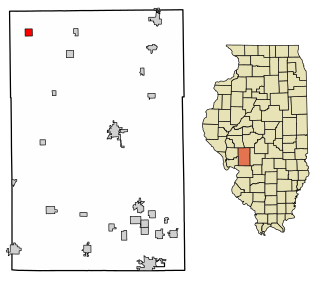
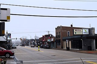
Industry is a village in McDonough County, Illinois, United States. As of the 2020 census, the village population was 399, down from 478 in 2010.

<span class="mw-page-title-main">Prairie City, Illinois</span> Village in Illinois, United States

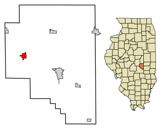
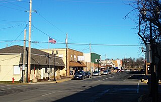
Prairie City is a village in McDonough County, Illinois, United States. The population was 407 at the 2020 census.

<span class="mw-page-title-main">Joy, Illinois</span> Village in Illinois, United States

Joy is a village in Mercer County, Illinois, United States. The population was 372 as of the 2020 census.

<span class="mw-page-title-main">Matherville, Illinois</span> Village in Illinois, United States

Matherville is a village in Mercer County, Illinois, United States. The population was 707 at the 2020 census.

<span class="mw-page-title-main">Reynolds, Illinois</span> Village in Illinois, United States

Reynolds is a village mainly in Rock Island County in the U.S. state of Illinois. The population was 498 at the 2020 census. A small portion on the south side is in Mercer County. The village was founded in 1876.

<span class="mw-page-title-main">Seaton, Illinois</span> Village in Illinois, United States

Seaton is a village in Mercer County, Illinois, United States. The population was 214 at the 2020 census.

<span class="mw-page-title-main">Windsor, Mercer County, Illinois</span> Village in Illinois, United States

Windsor, also known as New Windsor, is a village in Rivoli Township, Mercer County, Illinois, United States. The population was 668 at the 2020 census, down from 748 in 2010. The official name is the "Village of Windsor", but "New Windsor" is the commonly used name, including by the New Windsor Fire Department and the US Postal Service.

<span class="mw-page-title-main">Irving, Illinois</span> Village in Illinois, United States

Irving is a village in Montgomery County, Illinois, United States. The population was 373 at the 2020 census, down from 495 in 2010.

<span class="mw-page-title-main">Concord, Illinois</span> Village in Illinois, United States

Concord is a village in Morgan County, Illinois, United States. The population was 150 at the 2020 census. It is part of the Jacksonville Micropolitan Statistical Area.

<span class="mw-page-title-main">Franklin, Illinois</span> Village in Illinois, United States

Franklin is a village in Morgan County, Illinois, United States. The population was 610 at the 2020 census, unchanged from 2010. It is part of the Jacksonville Micropolitan Statistical Area.

<span class="mw-page-title-main">Bethany, Illinois</span> Village in Illinois, United States

Bethany is a village in Moultrie County, Illinois, United States. The population was 1,255 at the 2020 census, down from 1,352 in 2010.

<span class="mw-page-title-main">Milan, Illinois</span> Village in Illinois, United States

Milan is a village in Rock Island County, Illinois, United States. The population was 5,097 at the time of the 2020 census; down from 5,099 at the 2010 census.

<span class="mw-page-title-main">Morton, Illinois</span> Village in Illinois, United States

Morton is a village in Tazewell County, Illinois, United States. The population was 17,117 at the 2020 census. Morton is a suburb of Peoria, located southeast of Peoria, and is part of the Peoria Metropolitan Statistical Area. The community holds a yearly Morton Pumpkin Festival for a week every September, and claims that "99 percent of the world's canned pumpkin is produced in Morton," earning it the designation "Pumpkin Capital of the World"..

Mount Cobb is an unincorporated community and census-designated place (CDP) in Lackawanna County, Pennsylvania, United States. The population was 1,799 at the 2010 census.

<span class="mw-page-title-main">Bear Creek Village, Pennsylvania</span> Borough in Pennsylvania, United States

Bear Creek Village is a borough in Luzerne County, Pennsylvania, United States. The population was 290 at the 2020 census.

References

  1. 1 2 "2022 U.S. Gazetteer Files: Illinois". United States Census Bureau. Retrieved March 15, 2023.
  2. 1 2 "P1. Race – Sherrard village, Illinois: 2020 DEC Redistricting Data (PL 94-171)". U.S. Census Bureau. Retrieved March 15, 2023.
  3. "US Gazetteer files: 2010, 2000, and 1990". United States Census Bureau. February 12, 2011. Retrieved April 23, 2011.
  4. "Census of Population and Housing". Census.gov. Retrieved June 4, 2015.
  5. "U.S. Census website". United States Census Bureau . Retrieved January 31, 2008.
  6. "Sherrard CUSD 200: Our Schools" . Retrieved March 15, 2023.