Windsor, Mercer County, Illinois

Last updated

New Windsor, Illinois
Village of Windsor
Mercer County Illinois Incorporated and Unincorporated areas Windsor Highlighted.svg
Location in Mercer County, Illinois
Coordinates: 41°12′6″N90°26′38″W / 41.20167°N 90.44389°W / 41.20167; -90.44389
Country United States
State Illinois
County Mercer
Township Rivoli Township
Area
[1]
  Total0.44 sq mi (1.14 km2)
  Land0.44 sq mi (1.14 km2)
  Water0.00 sq mi (0.00 km2)
Elevation
805 ft (245 m)
Population
 (2020) [2]
  Total668
  Density1,525.11/sq mi (588.41/km2)
Time zone UTC-6 (CST)
  Summer (DST) UTC-5 (CDT)
ZIP code
61465
Area code 309
FIPS code 17-82309
GNIS feature ID2399713

Windsor, also known as New Windsor, is a village in Rivoli Township, Mercer County, Illinois, United States. The population was 668 at the 2020 census, [2] down from 748 in 2010. The official name is the "Village of Windsor", but "New Windsor" is the commonly used name, including by the New Windsor Fire Department [3] and the US Postal Service (ZIP Code 61465). [4]

Contents

Geography

New Windsor is located on the eastern edge of Mercer County at 41°12′6″N90°26′38″W / 41.20167°N 90.44389°W / 41.20167; -90.44389 (41.201643, -90.443996). [5] The eastern border of the village is also the Henry County line.

Illinois Route 17 passes through the village as its Main Street. It leads west 7 miles (11 km) to Viola and 16 miles (26 km) to Aledo, the Mercer county seat, and east-southeast 8 miles (13 km) to Woodhull and Interstate 74.

According to the U.S. Census Bureau, the village has a total area of 0.44 square miles (1.1 km2), all land. [1] It sits on a low ridge that drains south to North Pope Creek and north to a tributary of Parker Run, which continues north to the Edwards River. Pope Creek and the Edwards are west-flowing direct tributaries of the Mississippi River.

Demographics

Historical population
CensusPop.Note
1870 379
1880 51335.4%
1890 477−7.0%
1900 473−0.8%
1910 66039.5%
1920 484−26.7%
1930 444−8.3%
1940 51716.4%
1950 56910.1%
1960 65815.6%
1970 7239.9%
1980 86319.4%
1990 774−10.3%
2000 720−7.0%
2010 7483.9%
2020 668−10.7%
U.S. Decennial Census [6]

As of the census [7] of 2000, there were 720 people, 307 households, and 217 families residing in the village. The population density was 1,628.5 inhabitants per square mile (628.8/km2). There were 335 housing units at an average density of 757.7 per square mile (292.5/km2). The racial makeup of the village was 98.75% White, 0.28% Native American, 0.28% Asian, and 0.69% from two or more races. Hispanic or Latino of any race were 2.50% of the population.

There were 307 households, out of which 28.7% had children under the age of 18 living with them, 59.6% were married couples living together, 6.8% had a female householder with no husband present, and 29.3% were non-families. 28.0% of all households were made up of individuals, and 18.9% had someone living alone who was 65 years of age or older. The average household size was 2.35 and the average family size was 2.82.

In the village, the population was spread out, with 22.1% under the age of 18, 8.9% from 18 to 24, 24.4% from 25 to 44, 25.4% from 45 to 64, and 19.2% who were 65 years of age or older. The median age was 41 years. For every 100 females, there were 97.3 males. For every 100 females age 18 and over, there were 92.1 males.

The median income for a household in the village was $37,500, and the median income for a family was $41,094. Males had a median income of $30,556 versus $18,594 for females. The per capita income for the village was $19,811. About 6.1% of families and 7.8% of the population were below the poverty line, including 7.0% of those under age 18 and 10.3% of those age 65 or over.

Related Research Articles

<span class="mw-page-title-main">Mercer County, Illinois</span> County in Illinois, United States

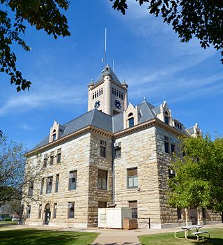
Mercer County is a county in Illinois. According to the 2020 census, it had a population of 15,699. Its county seat is Aledo.

<span class="mw-page-title-main">Bureau Junction, Illinois</span> Village in Illinois, United States

Bureau Junction, usually called Bureau, is a village in Bureau County, Illinois, United States. The population was 281 at the 2020 census. The village name is shown as both "Bureau Junction" and "Bureau" on federal maps, and is commonly called "Bureau", including by phone companies and the United States Post Office. It is part of the Ottawa Micropolitan Statistical Area. Bureau Junction was the point where the Rock Island Line railroad's branch line to Peoria split. Track west and south of Bureau is operated by Iowa Interstate, while tracks east to Chicago were formerly operated by CSX but are currently leased to Iowa Interstate.

<span class="mw-page-title-main">Indian Head Park, Illinois</span> Village in Illinois, United States

Indian Head Park is a village in Cook County, Illinois, United States, slightly north of the intersection of Interstate 294 and Interstate 55. The village is south of Western Springs, west of Countryside, north and east of Burr Ridge. Per the 2020 census, the population was 4,065. The village's ZIP code is 60525.

<span class="mw-page-title-main">Woodhull, Illinois</span> Village in Illinois, United States

Woodhull is a village in Henry County, Illinois. As of the 2010 census, the village had a population of 811, up from 809 in 2000.

<span class="mw-page-title-main">White City, Illinois</span> Village in Illinois, United States

White City is a village in Macoupin County, Illinois, United States. The population was 212 as of the 2020 census.

<span class="mw-page-title-main">Joy, Illinois</span> Village in Illinois, United States

Joy is a village in Mercer County, Illinois, United States. The population was 372 as of the 2020 census.

<span class="mw-page-title-main">Keithsburg, Illinois</span> City in Illinois, United States

Keithsburg is a city in Mercer County, Illinois, United States, on the Mississippi River. The population was 550 at the 2020 census, down from 609 in 2010. It was named for Robert Keith, a pioneer settler. Due to a flood in 1993, there isn’t much to do in Keithsburg. Some of the only things that are still in use today include, a bar/restaurant named “The Eagles Nest”, a gas station called “Casey’s”, and one or two playgrounds.

<span class="mw-page-title-main">Matherville, Illinois</span> Village in Illinois, United States

Matherville is a village in Mercer County, Illinois, United States. The population was 707 at the 2020 census.

<span class="mw-page-title-main">New Boston, Illinois</span> City in Illinois, United States

New Boston is a city in Mercer County, Illinois, United States on the Mississippi River. The population was 613 at the 2020 census, down from 683 in 2010.

<span class="mw-page-title-main">North Henderson, Illinois</span> Village in Illinois, United States

North Henderson is a village in Mercer County, Illinois, United States. The population was 162 at the 2020 census.

<span class="mw-page-title-main">Reynolds, Illinois</span> Village in Illinois, United States

Reynolds is a village mainly in Rock Island County in the U.S. state of Illinois. The population was 498 at the 2020 census. A small portion on the south side is in Mercer County. The village was founded in 1876.

<span class="mw-page-title-main">Seaton, Illinois</span> Village in Illinois, United States

Seaton is a village in Mercer County, Illinois, United States. The population was 214 at the 2020 census.

<span class="mw-page-title-main">Sherrard, Illinois</span> Village in Illinois, United States

Sherrard is a village in Mercer County, Illinois, United States. The population was 692 at the 2020 census.

<span class="mw-page-title-main">Viola, Illinois</span> Village in Illinois, United States

Viola is a village in Mercer County, Illinois, United States. The population was 869 at the 2020 census, a decline of 9 percent from 955 in 2010.

<span class="mw-page-title-main">Oak Grove, Illinois</span> Village in Illinois, United States

Oak Grove is a village in Rock Island County, Illinois, United States. The population was 476 at the time of the 2020 census; up from 396 at the 2010 census.

<span class="mw-page-title-main">Albany, Illinois</span> Village in Illinois, United States

Albany is a village in Whiteside County, Illinois, United States. The population was 891 at the 2010 census, down from 895 in 2000.

<span class="mw-page-title-main">Windsor Heights, Iowa</span> City in Iowa, United States

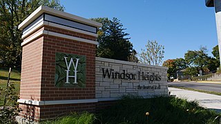
Windsor Heights is a city in Polk County, Iowa, United States. The population was 5,252 at the time of the 2020 census. It is part of the Des Moines–West Des Moines Metropolitan Statistical Area.

<span class="mw-page-title-main">Glasgow Village, Missouri</span> CDP in Missouri, United States

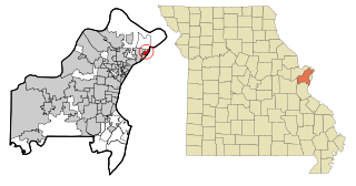
Glasgow Village is a census-designated place (CDP) in St. Louis County, Missouri, United States. The population was 5,429 at the 2010 census.

<span class="mw-page-title-main">Stoneboro, Pennsylvania</span> Borough in Pennsylvania, United States

Stoneboro is a borough in eastern Mercer County, Pennsylvania, United States. The population was 946 at the 2020 census. It is part of the Hermitage micropolitan area.

<span class="mw-page-title-main">Capron, Virginia</span> Town in Virginia, United States

Capron is a town in Southampton County, Virginia, United States. The population was 141 at the 2020 census.

References

  1. 1 2 "2022 U.S. Gazetteer Files: Illinois". United States Census Bureau. Retrieved March 16, 2023.
  2. 1 2 "P1. Race – Windsor village, Illinois: 2020 DEC Redistricting Data (PL 94-171)". U.S. Census Bureau. Retrieved March 16, 2023.
  3. "New Windsor Fire & Hose Co No. 1". NWFD. Retrieved March 16, 2023.
  4. "Cities by ZIP Code: 61465". U.S. Postal Service. Retrieved March 16, 2023.
  5. "US Gazetteer files: 2010, 2000, and 1990". United States Census Bureau. February 12, 2011. Retrieved April 23, 2011.
  6. "Census of Population and Housing". Census.gov. Retrieved June 4, 2015.
  7. "U.S. Census website". United States Census Bureau . Retrieved January 31, 2008.