Shippen Street (Weehawken)

Last updated
Shippen Street
Hudson County Route 682 NJ.svg
ShippenStreet.jpg
The second hairpin turn on Shippen Street
Shippen Street (Weehawken)
Part ofCR 682 jct.svg CR 682
NamesakeWilliam W. Shippen
Owner Township of Weehawken
Maintained by Weehawken Public Works
Length0.32 mi (0.51 km)
Location Weehawken
Coordinates 40°45′54″N74°01′32″W / 40.76500°N 74.02556°W / 40.76500; -74.02556
West endCR 685 jct.svg CR 685 (Palisade Avenue) in Weehawken
East endCR 691 jct.svg CR 691 (Hackensack Plank Road) in Weehawken
NorthDodd Street
SouthOak Street

Shippen Street is an east-west street in Weehawken, New Jersey. The eastern terminal, a cobblestone double hairpin turn is listed on the New Jersey Register of Historic Places. [1] [2] Shippen Street was developed at the start of the 20th century as part of the Weehawken Heights, [3] one of the town's residential neighborhoods.

Contents

Route description

At its western end, Shippen Street begins at Palisade Avenue, where over the city line in Union City it is now known as 24th Street, and creates the northern border for Elsworth Park, a city square from the 19th century. The two-way street gradually descends as it is intersected first by northbound Hudson Avenue and then southbound Gregory Avenue. At its eastern end, the street provides a view of the Lincoln Tunnel Helix and, directly across the North River, of the Empire State Building and New York Skyline. Shippen Street then becomes an eastbound one-way street that ends at Hackensack Plank Road. In its entirety, the street is about 1690 feet.

History

An 1841 map showing the Hoboken Land and Improvement Company holdings. Weehawken Heights was the site of Mountain Pavilion (center) Hamilton monument map.jpg
An 1841 map showing the Hoboken Land and Improvement Company holdings. Weehawken Heights was the site of Mountain Pavilion (center)

Shippen Street was named after William W. Shippen, who owned large properties in Weehawken Heights [3] next to those in West Hoboken belonging to the Hoboken Land and Improvement Company, of which he was the president for 21 years. [4] [5] A prominent German immigrant population in the area during the late 19th century included large groups of anarchists; several saloons could be found in the Union Hill area. The largest assembly hall, The New Casino, was on Shippen Street. [6] Although it now ends at Palisades, in the past the name Shippen Street was used at least as far as Central Avenue, [7] where it was once proposed by the city government and townspeople to repurpose a 200-foot shaft used to build the railroad tunnels as a station stop that would provide North Hudson's then-130,000 residents within a 1-mile radius of the shaft with transportation to the Pennsylvania Station being constructed in Manhattan. In 1904, the Geological Society surveyed the area, [8] but ultimately no stop was made on Shippen Street. A few years later in 1907, 125 men working in the North River Tunnels were forced to evacuate through the Shippen Street opening when tar paper used for waterproofing caught fire. Eleven men were unaccounted for upon the initial count; they were found 500 feet from the shaft at Shippen alive but unconscious, and had apparently survived by inhaling oxygen through a compressed air pipe which they hacked through. Although some were hospitalized with serious injury, none were reported dead. [9]

Double hairpin

Shippen Street hairpin photograph from early 20th century; the cobblestone street and trap rock walls remain in good condition. Shippenstreetold.png
Shippen Street hairpin photograph from early 20th century; the cobblestone street and trap rock walls remain in good condition.

At the eastern end of Shippen Street a double hairpin road begins, connecting the steep grade from Shippen Street to Hackensack Plank Road. [3] It has been called "The Horseshoe" and "Lombard Street of the East Coast". [10] With Hackensack Plank Road already in decades worth of usage and regularity and Shippen Street residential properties extending to the edge of the cliff side, transportation planners and engineers were left little option to connect the two street other than creating a hairpin style turn portion, whereas a perpendicular intersection between the two roads would have created too great of a slope gradient for pedestrians, carriages or automobiles to traverse safely. It was placed on the New Jersey Register of Historic Places on December 8, 1997 under its list of historic preservation sites. [11]

Entering the turns first require a 90° turn where the road remains paved with concrete. The road becomes cobblestone after the second turn, a 180° turn. The third turn, also a 180° turn, is housed completely by the original stone wall. Finally, the last turn is out onto Hackensack Plank Road which if going southbound, requires another 180° turn and ends the cobblestone portion of the street. The one-way hairpin road is about 440 ft. when traveled along the centerline path.[ citation needed ]

At the north side is a staircase connecting the upper and lower ends of the hairpins, which allows pedestrians to avoid the walk where there are no sidewalks. Both sets of stairs accommodated many workers commuting to the factories on Gregory Avenue. The buildings overlooking the Horseshoe, as it has always been known by the locals, was the factory of S. Blickman & Co. which operated a stainless steel fabricating plant at the site for about 70 years. The plant produced stainless steel for many industrial and commercial purposes and was oriented to outfitting the many ships built along the Hoboken waterfront in Todd Shipyards (the family of former Governor Christy Todd Whitman) and Bethlehem Steel Shipyards. It produced most of the stainless steel equipment used to outfit Naval vessels constructed on the East coast during the Second World War. Blickman outgrew the factory and eventually the disused building was converted to condominiums in the 1980s. Farther down the street on the corner of Gregory and Hackensack Plank Road was the factory of Robert Reiner & Co. which imported and customized Swiss embroidery machines when Hudson County was the center of the embroidery industry in the US in the first half of the 20th century. During the time of their operation Shippen Street was the only local street capable of accommodating the turn of many large tractor trailer trucks which served these two large and active factories. Delivering truck size rolls of stainless steel and carrying away the often huge finished products fit for outfitting large ships. No parking was permitted on Gregory Avenue until the factories both ceased operation.[ citation needed ]

Shippen Steps

ShippenSteps.jpg

At the end of Shippen Street, directly across from the double hairpin curve are the Shippen Steps, an outdoor public staircase down the Palisades Cliffs which continues in the same direction as Shippen Street. They begin on Hackensack Plank road and end at Park Avenue. There are 96 steps, with a diagonal span in length of about 250 feet. In the past, the steps provided townspeople with access to Weehawken's original town hall, as well as the old police station, which was headquarter in the building at 309 Park Avenue. It was built in 1890, and the first floor features a jail cell where police operations occurred. The building was last used as the VFW post 1923 meeting place. [12] [13] In 2009, the town decided to renovate the building, which became the Weehawken Historical Society Museum. Across the street at the bottom of the steps is the granite wall which overlooks the art deco Lincoln Tunnel entrance. The Shippen steps have even been regarded as the haunted "Steps of Weehawken". [14] In the mid-to-late 19th century, a pregnant woman fell down the steps, losing both her life and her child's, [15] and in 1898, it was reported that a Shippen Street resident committed suicide at the head of the steps. [16]

Transportation

New Jersey Transit Bus Route 123 makes a stop at the top of Shippen Street along Palisade Avenue, [17] [18] and runs between the Port Authority Bus Terminal and Christ Hospital in Jersey City Heights. a few blocks to the south is the Marginal Highway, a main transit corridor for North Hudson-Lincoln Tunnel traffic. On the other side, the Shippen Stairs end about .25 mi. from the Hudson Bergen Light Rail Lincoln Harbor Station and New York Waterway ferries, though pedestrian access requires a detour around the tunnel's toll plaza.

See also

Related Research Articles

<span class="mw-page-title-main">Weehawken, New Jersey</span> Township in Hudson County, New Jersey, United States

Weehawken is a township in the northern part of Hudson County, in the U.S. state of New Jersey. It is located on the Hudson Waterfront and Hudson Palisades overlooking the Hudson River. As of the 2020 United States census, the township's population was 17,197, an increase of 4,643 (+37.0%) from the 2010 census count of 12,554, which in turn reflected a decline of 947 (−7.0%) from the 13,501 counted in the 2000 census.

<span class="mw-page-title-main">Timeline of Jersey City, New Jersey-area railroads</span>

For the purposes of this article, the Jersey City area extends North to Edgewater, South to Bayonne and includes Kearny Junction and Harrison but not Newark. Many routes east of Newark are listed here.

<span class="mw-page-title-main">2nd Street station (Hudson–Bergen Light Rail)</span>

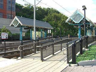
2nd Street station is a station on the Hudson–Bergen Light Rail (HBLR) located west of Marshall Street near the foot of Paterson Plank Road in Hoboken, New Jersey. There are two tracks and two side platforms.

Paterson Plank Road is a road that runs through Passaic, Bergen and Hudson Counties in northeastern New Jersey. The route, originally laid in the colonial era, connects the city of Paterson and the Hudson River waterfront. It has largely been superseded by Route 3, but in the many towns it passes it has remained an important local thoroughfare, and in some cases been renamed.

<span class="mw-page-title-main">The Heights, Jersey City</span> District of Jersey City, New Jersey, United States

The Heights or Jersey City Heights is a neighborhood in Jersey City, New Jersey, located atop the New Jersey Palisades, along the west side of the Hudson River. It is bound by Paterson Plank Road on the north, Highway 139 on the south, Hoboken on the east, and the Hackensack River on the west. and Penhorn Creek on the west. Its postal area ZIP Codes are 07307, and portions of 07306.

<span class="mw-page-title-main">Hackensack Plank Road</span>

The Hackensack Plank Road, also known as Bergen Turnpike, was a major artery which connected the cities of Hoboken and Hackensack, New Jersey. Like its cousin routes, the Newark Plank Road and Paterson Plank Road, it travelled over Bergen Hill and across the Hackensack Meadows from the Hudson River waterfront to the city for which it was named. It was originally built as a colonial turnpike road as Hackensack and Hoboken Turnpike. The route mostly still exists today, though some segments are now called the Bergen Turnpike. It was during the 19th century that plank roads were developed, often by private companies which charged a toll. As the name suggests, wooden boards were laid on a roadbed in order to prevent horse-drawn carriages and wagons from sinking into softer ground on the portions of the road that passed through wetlands. The company that built the road received its charter on November 30, 1802. The road followed the route road from Hackensack to Communipaw that was described in 1679 as a "fine broad wagon-road."

<span class="mw-page-title-main">Bergen Hill</span> Lower part of the Hudson Palisades, New Jersey, United States

Bergen Hill refers to the lower Hudson Palisades in New Jersey, where they emerge on Bergen Neck, which in turn is the peninsula between the Hackensack and Hudson Rivers, and their bays. In Hudson County, it reaches a height of 260 feet.

<span class="mw-page-title-main">Weehawken Terminal</span> Former intermodal terminal in Weehawken, New Jersey

Weehawken Terminal was the waterfront intermodal terminal on the North River in Weehawken, New Jersey for the New York Central Railroad's West Shore Railroad division, whose route traveled along the west shore of the Hudson River. It opened in 1884 and closed in 1959. The complex contained five ferry slips, sixteen passenger train tracks, car float facilities, and extensive yards. The facility was also used by the New York, Ontario and Western Railway. The terminal was one of five passenger railroad terminals that lined the Hudson Waterfront during the 19th and 20th centuries; the others were located at Hoboken, Pavonia, Exchange Place and Communipaw, with Hoboken being the only one still in use.

<span class="mw-page-title-main">Hackensack Water Company Complex</span> United States historic place

The Hackensack Water Company Complex is a set of historic buildings in Weehawken, New Jersey, registered in the U.S. National Register of Historic Places. The Hackensack Water Company, a predecessor of Suez North America, developed water supply and storage in northeastern New Jersey from the 1870s to the 1970s, initially to provide service to the city of Hackensack and the towns of North Hudson. Originally its headquarters and major facilities were located at Hackensack, in Bergen County. Under Robert W. de Forest, who ran the Hackensack Water Company for 46 years beginning in 1881, the company constructed new facilities and moved its headquarters to Weehawken in Hudson County, setting up offices in a brick water tower, part of the present complex.

<span class="mw-page-title-main">Hudson Waterfront</span> Place in Hudson and Bergen

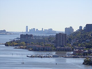
The Hudson Waterfront is an urban area of northeastern New Jersey along the lower reaches of the Hudson River, the Upper New York Bay and the Kill van Kull. Though the term can specifically mean the shoreline, it is often used to mean the contiguous urban area between the Bayonne Bridge and the George Washington Bridge that is approximately 19 miles (31 km) long. Historically, the region has been known as Bergen Neck, the lower peninsula, and Bergen Hill, lower Hudson Palisades. It has sometimes been called the Gold Coast.

<span class="mw-page-title-main">Historic districts in Hudson County, New Jersey</span> Historic districts in Hudson County, New Jersey, US

Hudson County, New Jersey has historic districts which have been designated as such on a municipal, state, or federal level, or combination therof. Some are listed on New Jersey Register of Historic Places and are included on National Register of Historic Places listings in Hudson County, New Jersey. The following is intended to be a list of places which encompasses an area or group of buildings or structures.

<span class="mw-page-title-main">Summit Avenue (Hudson Palisades)</span> Road in Hudson County, New Jersey, US

County Route 617 is 4.55-mile (7.32 km) long and follows one street, Summit Avenue along the ridge of the Hudson Palisades in Hudson County, New Jersey. Its southern end is CR 622, or Grand Street, at Communipaw Junction in the Bergen-Lafayette Section of Jersey City. Its northern end is CR 691, 32nd Street, a section of the Bergen Turnpike, in Union City.

<span class="mw-page-title-main">Central Avenue (Hudson Palisades)</span> Populated place in Hudson County, New Jersey, US

Central Avenue is a 12-block-long thoroughfare in the Heights neighborhood of Jersey City, New Jersey, United States. One of 13 shopping districts in the city, it is designated County Route 663 for 1.60-mile (2.57 km) of its length. It originates at the intersection of Summit Avenue and Pavonia Avenue, and runs north, intersecting Newark Avenue one block east of Five Corners to Paterson Plank Road near Transfer Station. The avenue continues north through Union City without the county route designation to 35th Street, two blocks north of Hackensack Plank Road.

<span class="mw-page-title-main">Pershing Road (Weehawken)</span> Road ascending the Hudson Palisades in Weehawken, New Jersey

Pershing Road is a road located entirely in Weehawken, New Jersey that travels for 0.42 miles (0.68 km) on the Hudson Palisades between Boulevard East and Weehawken Port Imperial, and carries the designation Hudson County Route 682. At County Route 505, the road meets 48th Street, one of the very few two-way streets in the urban grid of North Hudson, which travels west to Bergenline Avenue and Kennedy Boulevard. It is named for World War I hero John J. Pershing. Earlier names have included Clifton Road, named for the estate on whose land it was located, and Hillside Road, which would speak to its location.

<span class="mw-page-title-main">North Hudson County Railway</span>

The North Hudson Railway Company built and operated a streetcar system in Hudson County and southeast Bergen County, New Jersey before and after the start of the 20th century. It was founded by Hillric J. Bonn who became the first President in 1865 and served for 26 years until his death, and eventually taken over by the Public Service Railway. In its endeavors to overcome the formidable obstacle of ascending the lower Hudson Palisades, or Bergen Hill, it devised numerous innovative engineering solutions including funicular wagon lifts, an inclined elevated railway, an elevator and viaducts.

<span class="mw-page-title-main">14th Street (Hoboken)</span> County highway in Hudson County, New Jersey, United States

14th Street is a county highway in Hudson County, New Jersey, designated County Route 670. It begins at an intersection with Manhattan Avenue in Union City, also known as the South Wing Viaduct, and proceeds east over the 14th Street Viaduct to terminate at Sinatra Drive on the banks of the Hudson River in Hoboken. It is located at the northern end of Hoboken's street grid, and one of the only east–west streets in the city that allows for two-way traffic. It is located two blocks south of Weehawken Cove.

<span class="mw-page-title-main">Palisade Avenue (Hudson Palisades)</span>

Palisade Avenue is the name given to a historic road which parallels the eastern crest of Hudson Palisades in northeastern New Jersey. It travels between Jersey City and Fort Lee, passing through Jersey City Heights, North Hudson, and Cliffside Park, with various parts carrying Hudson and Bergen county route designations. The avenue re-aligns itself at several places along its route as it crosses traditional municipal boundaries created in the 19th century. As a primary route running along the top of the Hudson Palisades, many segments offer scenic views of the Hudson River and the New York skyline. Since 2020 there is proposed state legislation to restrict building heights that would rise above the cliffs on the eastern side of Palisade Avenue along the entire corridor from Jersey City to Fort Lee.

<span class="mw-page-title-main">Mountain Pavilion</span> Inn in New Jersey

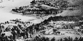
The Mountain Pavilion was an inn located in Weehawken, New Jersey during the 19th century.

References

  1. NJ State Register of Historic Places in Hudson County Archived 2010-07-05 at the Wayback Machine
  2. Weehawken Time Machine
  3. 1 2 3 Lauren Sherman, Ellen Robb Gaulkin Weehawken. p. 61, Arcadia Publishing, 2009 ISBN   0-7385-6268-8
  4. "Sewers For West Hoboken" (PDF). The New York Times. July 7, 1887.
  5. Obituary: William W. Shippen. The New York Times. September 3, 1885
  6. Tom Goyens Beer and revolution: the German anarchist movement in New York City, 1880-1914, University of Illinois Press, 2007 ISBN   0-252-03175-X
  7. Annual report of the Board of Public Utility Commissioners of the State New Jersey. Board of Public Utility Commissioners, Issue 7, p. 75, 2008
  8. Bulletin of the Geological Society of America, Volume 16: Projected Hudson River tunnels of the Pennsylvania Railroad Company, 1905
  9. "11 Overcome in Tube". The New York Times. December 6, 1907
  10. New Jersey Roads: Shippen Street, Weehawken
  11. DEP - Historic Preservation Office: New Jersey and National Registers of Historic Places NJ Register of Historic Places Archived 2010-07-05 at the Wayback Machine
  12. "Shippen Street and Park Avenue". Ancestry.com. Retrieved May 31, 2019.
  13. Allocca, Sean (August 2, 2009). "Modern Day Makeover: Former VFW Lode, a one-time Town Hall, will be restored". The Hudson Reporter. Archived from the original on March 6, 2012. Retrieved May 31, 2019. Alt URL
  14. Diaz, Lana Rose (April 29, 2010). "Don't try this at home: Guys explore ancient steps in Weehawken". The Hudson Reporter. Archived from the original on 2019-05-31.
  15. "Weehawken Surnames". Ancestry.com. Retrieved May 31, 2019.
  16. "Lost money and killed himself". The New York Times. January 7, 1898
  17. NJT bus 123 schedule
  18. "NJT Jersey City, Union City, New York Bus Routes" (PDF). New Jersey Department of Transportation . Retrieved 2010-04-25.