Shoshong

Last updated
Shoshong
Botswana location map.svg
Red pog.svg
Shoshong
Coordinates: 23°02′S26°31′E / 23.033°S 26.517°E / -23.033; 26.517 Coordinates: 23°02′S26°31′E / 23.033°S 26.517°E / -23.033; 26.517
CountryFlag of Botswana.svg  Botswana
District Central District
Population
 (2022)
  Total8,887
Time zone UTC+2 (Central Africa Time)
  Summer (DST) UTC+2 (not observed)
ISO 3166 code BW-CE
Climate BSh

Shoshong is a town in Botswana, formerly the chief settlement of the eastern Bamangwato. [1]

Contents

Physical location

Shoshong is located just north of the Tropic of Capricorn at 23°02′S26°31′E / 23.033°S 26.517°E / -23.033; 26.517 , in the Central District of Botswana, about 40 km (25 mi) west of Mahalapye. The town is situated 3,000 ft (910 m) above sea level in the valley of the Shoshong, an intermittent tributary of the Limpopo. [1] Nearby villages are Tobela, Ikongwe, Kalamare, Mmutlane, and Mosolotshane. [2]

Shoshong is encircled by hills used for grazing cattle, and is a windy place. The central kgotla is located by the mouth of the steep valley (kloof) which used to be the source of water for the village. [3]

History

Shoshong was initially inhabited by BaPhaleng, [4] who were later joined by Bakaa, and later BaNgwato under King Sekgoma I. Oral traditions from the village points that the Baphaleng chief invited Bangwato from Mosu where they were continuously harassed and vulnerable to Matebele attacks. The site of Shoshong was chosen as being easily defensible against the Matabele. [1]

Bamangwato huts at Shoshong, 1881 Seven Years in South Africa, page 372, Bamangwato huts at Shoshong.jpg
Bamangwato huts at Shoshong, 1881

Being the meeting place of trade routes from south and north it was of considerable importance to early explorers (including David Livingstone) and traders in South-Central Africa. [1]

A mission station of the London Missionary Society (preceded for many years by a station of the Hermannsburg Lutheran Missionary Society) was founded here in 1862. [1] Scottish missionary John Mackenzie (1835–99), who lived at Shoshong from 1862 to 1876, "believed that the Ngwato and other African peoples with whom he worked were threatened by Boer freebooters encroaching on their territory from the south", and campaigned "for the establishment of what became the Bechuanaland Protectorate, to be ruled directly from Britain." [5]

In 1875, King Sekgoma was overthrown here by his Christian son Khama (later Khama III or Khama the Great). In 1885 (at the time of the declaration of the British protectorate of Bechuanaland) Shoshong had 20,000 to 30,000 inhabitants, including about twenty Europeans. [1]

The move to Palapye

By the 1880s, Shoshong had existed in the same location for forty years, possibly a record for a Tswana town. But it became a 'Desert City', almost waterless with 'one trickling well' and with 'indescribable filth'. Due to the water shortage in 1888/1889, Khama and most of his followers moved to Phalatswe/Old Palapye, 95km (60 miles) N.E. of Shoshong, and later to Serowe to the north-west of Palapye. [1] Like Shoshong, these places were built in valleys of tributaries of the Limpopo. [1] To make up for the loss of the defensible location, Khama had made an alliance with the British who were preparing a forward movement to take over Mashonaland and Matabeleland. [6]

However, by 1898, Phalatswe was also running short of water, and Khama ordered some of his people back to Shoshong. The BaPhaleng returned in 1900 and the Bakaa in 1902, while the capital relocated to Serowe. At the publication of the 1911 Encyclopædia Britannica, Shoshong had a population of about 800. [1]

Modern Shoshong

In the 2001 census, the population of "Shoshong and Associated Localities" was listed as 11,176 people, including 7,490 in "Village Shoshong". [7] [8] According to Botswana 2022 Population and Housing Census, Preliminary results volume 2, Shoshong has registered a population growth decline of 0.9%. The village has a boarding school, therefore the decline could be attributed to the fact that students were enumerated at their usual place of residence even when they were not present during enumeration. Currently, Shoshong has 8,827 population compared to 9,678 of 2011. [9]

In 2012, Kgosi Sediegeng Kgamane decision to install his son as chief created controversy. Kgamane is described as "a prominent Mongwato royal and uncle to president Ian Khama." [10]

Historically Shoshong’s chieftainship had been held by three tribes from three different wards of the Bakaa, BaPhaleng and Bagwato simultaneously sitting at the Kgotla to deliberate the issues of the people. [11]

Related Research Articles

The Batswana, a term also used to denote all citizens of Botswana, refers to the country's major ethnic group. Prior to European contact, the Batswana lived as herders and farmers under tribal rule.

<span class="mw-page-title-main">Mafikeng</span> Capital city of the North-West Province, South Africa

Mafikeng, officially known as Mahikeng and previously Mafeking, is the capital city of the North West province of South Africa.

<span class="mw-page-title-main">Khama III</span> King (Kgosi) of the Bangwato people of central Botswana (r. 1875–1923)

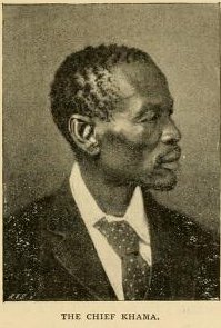
Khama III (1837?–1923), referred to by missionaries as Khama the Good also called Khama the Great, was the Kgosi of the Bangwato people.

Sir Seretse Goitsebeng Maphiri Khama, GCB, KBE was a Motswana politician who served as the first President of Botswana, a post he held from 1966 to his death in 1980.

<span class="mw-page-title-main">Bechuanaland Protectorate</span> British protectorate in southern Africa, became Botswana in 1966

The Bechuanaland Protectorate was a protectorate established on 31 March 1885, by the United Kingdom of Great Britain and Ireland in Southern Africa. It became the Republic of Botswana on 30 September 1966.

Serowe is an urban village in Botswana's Central District. A trade and commercial centre, it is Botswana's third largest village. Serowe has played an important role in Botswana's history, as capital for the Bamangwato people in the early 20th century and as birthplace of several of Botswana's presidents. More recently it has undergone significant development as the town and as Botswana continues to grow.

Palapye is a growing town in Botswana, situated about halfway between Francistown and Gaborone. Over the years its position has made it a convenient stopover on one of Southern Africa's principal north–south rail and road routes.

<span class="mw-page-title-main">Central District (Botswana)</span> District in Botswana

Central is the largest of Botswana's districts in terms of area and population. It encompasses the traditional homeland of the Bamangwato people. Some of the most politically connected Batswana have come from the Central District, including former President Sir Seretse Khama, former President Festus Mogae, and former President Lt. General Seretse Ian Khama. The district borders the Botswanan districts of Chobe in the north, North-West in the northwest, Ghanzi in the west, Kweneng in southwest, Kgatleng in the south and North-East in the northeast, as well as Zimbabwe also in the northeast and South Africa in the southeast.

The Bamangwato is one of the eight "principal" Tswana chieftaincies of Botswana. They ruled over a majority Bakalanga population, with minorities including the Basarwa, Birwa and Tswapong. The modern Bamangwato formed in the Central District, with its main town and capital at Serowe. The paramount chief, a hereditary position, occupies one of the fifteen places in Ntlo ya Dikgosi, the national House of Chiefs.

<span class="mw-page-title-main">Sub-districts of Botswana</span>

The districts of Botswana are subdivided into sub-districts. The sub-districts are listed below, by district:

Serule is a village in Central District of Botswana. Serule, with a latitude of -21.95 and a longitude of 27.3, is a streets, highways, roads, or railroad. The village is located along the road between Francistown and Palapye, and is an important railroad junction with rails leading towards north to Francistown, south to Palapye and east to the mining town of Selebi-Phikwe, 72 km from Palapye north up the A1 road, 88 km from Francistown down south the A1 road and 60 km west of Selibe Phikwe to the T-junction. The location is situated 340 kilometers east (90°) of the approximate center of Botswana and 332 kilometers north east (26°) of the capital Gaborone.

The Ba-ka-Nswazwi people are originally Bapedi of Mujaji. The Bapedi of Mujaji are Kalangas originally from Munomutapa and were ruled by Mugudo. They are found in Tutume, Nswazwi, Marapong, Masunga and Nkange in Botswana.

<span class="mw-page-title-main">Tshekedi Khama</span> King (Kgosi) of Bechuanaland, Ruler of the Bangwato people of central Botswana

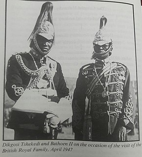
Tshekedi Khama was the regent-king of the Bamangwato tribe in 1926 after the death of Sekgoma II.

The history of Gaborone began with archaeological evidence in the area around Gaborone dating back to 400 BCE, and the first written accounts of Gaborone are from the earliest European settlers in the 19th century. Since the 1960s, when Botswana gained its independence from Britain and Gaborone became the capital, the city has grown from a small village in the Botswana scrubland to a major center in southern Africa.

The Independence Day of Botswana, commonly called Boipuso, is a national holiday observed in Botswana on September 30 of every year. The date celebrates Botswana's Declaration of Independence from the United Kingdom on September 30, 1966.

Mma-Besi or Mabisa was a mohumagadi of the BaNgwato of the Bechuanaland Protectorate, now Botswana, and the first wife of king Khama III. She was also known as Elisabeta Gobitsamang Khama.

Old Palapye is a heritage site located in Botswana, near a town called Palapye. Old Palapye and Palapye are two different places according to the residents there, Palapye is a modernised town. The site is located 20 km away from the Palapye town and the people living around call it Malaka village This monument site is called Old Palapye because it carries the history of the ancient nature which differentiates it from the Palapye town.

Sekgoma Memorial Hospital is a government-run district hospital located in Serowe, a town in Botswana's Central District. A trade and commercial centre, it is Botswana's largest village rich with the history of Botswana.

<span class="mw-page-title-main">Semane Setlhoko Khama</span> Mohumagadi (queen or queen mother) of the BaNgwato of the Bechuanaland Protectorate

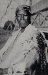
Semane Setlhoko Khama (1881–1937) was a mohumagadi of the BaNgwato chieftaincy in the Bechuanaland Protectorate. Educated in a missionary school, she became a teacher and upon her marriage to Khama III continued to press for education for the BaNgwato. A proponent of modern medicine, she was influential in bringing modern midwifery to the area. As a devout Christian, she encouraged women's involvement in the church and the Woman's Christian Temperance Union.

References

  1. 1 2 3 4 5 6 7 8 9 Chisholm, Hugh, ed. (1911). "Shoshong"  . Encyclopædia Britannica . Vol. 24 (11th ed.). Cambridge University Press. p. 1014.
  2. Central District Council, Central District Development Committee, Ministry of Local Government, Lands & Housing, 1997 - Botswana
  3. Knight, Jacob (2014). Shoshong: a short history (PDF). Kwangu. p. 21. ISBN   978-99968-0-225-6.
  4. Tlou and Campbell (1997); A.M. Chebanne and K.C. Monaka (2008)
  5. Mackenzie, John (1887). Austral Africa: Losing It or Ruling It; Being Incidents and Experiences in Bechuanaland, Cape Colony, and England. London: Sampson Low, Marston, Searle & Rivington,- via World Digital Library. Retrieved 2014-06-19.
  6. "The Abandonment of Phalatswe". www.thuto.org. Retrieved 2022-05-27.
  7. "Population_Towns Villages and associated localities by District_2001 Census" (PDF).{{cite web}}: CS1 maint: url-status (link)
  8. "Population_Towns Villages and associated localities by District_2001 Census, Botswana" (PDF). Statistics Botswana. Retrieved May 23, 2021.{{cite web}}: CS1 maint: url-status (link)
  9. "2022 Population and Housing Census Preliminary Results". Statistics Botswana. 2022-05-10. Retrieved 2022-05-27.
  10. Dipholo, Kabelo (2012-04-27). "TRIBAL WAR BREWING IN SHOSHONG". The Voice. Archived from the original on 2013-01-31. Retrieved 2014-06-19.
  11. Knight, Jacob (2014). Shoshong : a short history. Gaborone: Kwangu. pp. 11–12. ISBN   9789996802256.