| Shotwell, North Carolina | |
|---|---|
| Unincorporated community | |
Historic Oaky Grove Methodist Church in Shotwell, North Carolina | |
 Location of Shotwell in North Carolina  Shotwell, North Carolina (the US) | |
| Coordinates: 35°44′14″N78°26′41″W / 35.73722°N 78.44472°W Coordinates: 35°44′14″N78°26′41″W / 35.73722°N 78.44472°W | |
| Country | United States |
| State | North Carolina |
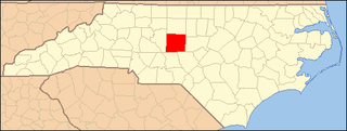
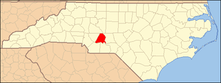
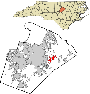
| County | Wake |
| Elevation [1] | 289 ft (88 m) |
| Time zone | Eastern (EST) (UTC-5) |
| • Summer (DST) | EDT (UTC-4) |
| Area code(s) | 919 |
| FIPS code | 61740 |
| GNIS feature ID | 1006371 [1] |

Shotwell is an unincorporated community in rural eastern Wake County, North Carolina, United States, located about 4 miles (6.4 km) south of Knightdale and 11 miles (18 km) east of Raleigh at the confluence of Smithfield, Mial Plantation, Major Slade, Grasshopper, and Turnipseed Roads. Shotwell has been inhabited since the early 19th century and is home to a number of historic structures. A post office was established in 1883 but closed less than two decades later. [2]
Wake County is a county in the U.S. state of North Carolina. As of July 1, 2015, the population was 1,024,198, making it North Carolina's second-most populous county. From July 2005 to July 2006, Wake County was the 9th fastest-growing county in the United States, with the town of Cary and the city of Raleigh being the 8th and 15th fastest-growing cities, respectively.
Knightdale is a town in Wake County, North Carolina, United States. As of the 2010 census, the population was 11,401. The U.S. Census Bureau estimates the town's population to be 13,291 as of July 1, 2013. Knightdale's population grew 10.4% from 2010-2012, making it the second fastest-growing community in the Research Triangle region for that time period.

Raleigh is the capital of the state of North Carolina and the seat of Wake County in the United States. Raleigh is the second-largest city in the state, after Charlotte. Raleigh is known as the "City of Oaks" for its many oak trees, which line the streets in the heart of the city. The city covers a land area of 142.8 square miles (370 km2). The U.S. Census Bureau estimated the city's population as 479,332 as of July 1, 2018. It is one of the fastest-growing cities in the country. The city of Raleigh is named after Sir Walter Raleigh, who established the lost Roanoke Colony in present-day Dare County.
Oaky Grove was listed on the National Register of Historic Places in 1993. [3]

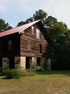
Oaky Grove is a historic house located in Shotwell, Wake County, North Carolina, a suburb of Raleigh. Built in 1818 by Thomas Price, Oaky Grove has been home to generations of the Price, Blake, and Doub families. Before the Civil War, the Price plantation consisted of 4,500 acres (1,800 ha) of farm land. Today, the 28-acre (11 ha) property is owned by the Doubs family and contains the two-story Federal style home, a smokehouse, barn, and the family cemetery.

The National Register of Historic Places (NRHP) is the United States federal government's official list of districts, sites, buildings, structures, and objects deemed worthy of preservation for their historical significance. A property listed in the National Register, or located within a National Register Historic District, may qualify for tax incentives derived from the total value of expenses incurred preserving the property.