Shute Harbour

Last updated

Shute Harbour
Queensland
Shute Harbour.jpeg
Shute Harbour
Australia Queensland location map.svg
Red pog.svg
Shute Harbour
Coordinates 20°17′24″S148°47′25″E / 20.2899°S 148.7902°E / -20.2899; 148.7902 Coordinates: 20°17′24″S148°47′25″E / 20.2899°S 148.7902°E / -20.2899; 148.7902
Population122 (2016 census) [1]
 • Density111/km2 (287/sq mi)
Postcode(s) 4802
Area1.1 km2 (0.4 sq mi)
LGA(s) Whitsunday Region
State electorate(s) Whitsunday
Federal Division(s) Dawson
Suburbs around Shute Harbour:
Mount Rooper Mount Rooper Coral Sea
Coral Sea Shute Harbour Coral Sea
Coral Sea Coral Sea Coral Sea

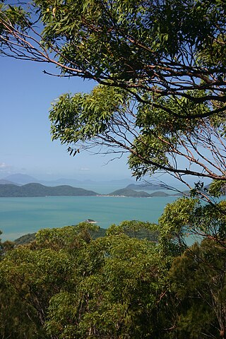
Shute Harbour is a coastal locality and harbour in the Whitsunday Region of Queensland, Australia. [2] [3] In the 2016 census, Shute Harbour had a population of 122 people. [1]

Suburbs and localities are the names of geographic subdivisions in Australia, used mainly for address purposes. The term locality is used in rural areas, while the term suburb is used in urban areas. Australian postcodes closely align with the boundaries of localities and suburbs.

Whitsunday Region Local government area in Queensland, Australia

The Whitsunday Region is a local government area located in North Queensland, Australia. Established in 2008, it was preceded by two previous local government areas with a history extending back to the establishment of regional local government in Queensland in 1879.

Queensland North-east state of Australia

Queensland is the second-largest and third-most populous state in the Commonwealth of Australia. Situated in the north-east of the country, it is bordered by the Northern Territory, South Australia and New South Wales to the west, south-west and south respectively. To the east, Queensland is bordered by the Coral Sea and Pacific Ocean. To its north is the Torres Strait, with Papua New Guinea located less than 200 km across it from the mainland. The state is the world's sixth-largest sub-national entity, with an area of 1,852,642 square kilometres (715,309 sq mi).

Contents

Geography

Shute Harbour is in sheltered port for small vessels located approximately 10 kilometres east of Airlie Beach. Serving mainly as a boarding point for ferries between the Whitsunday Islands and the mainland, it is also home to many charter boat operations and provides the best access to many Whitsunday island resorts and campsites.

Whitsunday Islands island group in Queensland, Australia

The Whitsunday Islands are a collection of continental islands of various sizes off the central coast of Queensland, Australia, approximately 900 kilometres north of Brisbane. The northernmost of the islands are situated off the coast by the town of Bowen while the southernmost islands are off the coast by Proserpine. The island group is centered on Whitsunday Island, while the group's commercial center is Hamilton Island. The traditional owners of the area are the Ngaro people and the Gia people whose Juru Clan has the only legally recognized native title in the region.

History

Shute Harbour takes its name from Shute Island which is about 500 metres (1,600 ft) south-east of the headland of Shute Harbour. [3] The island was named by in May 1881 by Captain John Fiot Lee Pearse Maclear of HMS Alert, possibly after a crew-member of that ship. [4]

HMS <i>Alert</i> (1856) 17-gun wooden screw sloop of the Cruizer class of the Royal Navy

HMS Alert was a 17-gun wooden screw sloop of the Cruizer class of the Royal Navy, launched in 1856 and broken up in 1894. She was the eleventh ship of the Royal Navy to bear the name, and was noted for her Arctic exploration work; in 1876 she reached a record latitude of 82° North. Alert briefly served with the US Navy, and ended her career with the Canadian Marine Service as a lighthouse tender and buoy ship.

When the Proserpine Shire Council decided to construct tourist facilities in the area in October 1960, they created a town called Shutehaven. [5] On 31 January 1987, the town of Shutehaven was amalgamated into a larger town of Whitsunday. [6]

Harbour facilities

View of vessels in Shute Harbour, 2000 Shute Harbour 2.JPG
View of vessels in Shute Harbour, 2000

Once second only to Sydney’s Circular Quay as the busiest commuter port in Australia and hosting the largest seaplane airbase in the Southern hemisphere, Shute Harbour has faced many years of uncertainty as most ferry operations have moved to marinas in Airlie Beach. Shute Harbour Transit Facility is managed by the Whitsunday Regional Council. Major redevelopment plans for the facility have been flagged due to ageing infrastructure, [7] however much uncertainty exists with the nature of these plans. There are regular bus and taxi services available to and from the port which take the winding road through Conway National Park towards the harbour.

Sydney City in New South Wales, Australia

Sydney is the state capital of New South Wales and the most populous city in Australia and Oceania. Located on Australia's east coast, the metropolis surrounds Port Jackson and extends about 70 km (43.5 mi) on its periphery towards the Blue Mountains to the west, Hawkesbury to the north, the Royal National Park to the south and Macarthur to the south-west. Sydney is made up of 658 suburbs, 40 local government areas and 15 contiguous regions. Residents of the city are known as "Sydneysiders". As of June 2017, Sydney's estimated metropolitan population was 5,230,330 and is home to approximately 65% of the state's population.

Circular Quay locality in Sydney, New South Wales, Australia

Circular Quay is a harbour, former working port and now international passenger shipping port, public piazza and tourism precinct, heritage area, and transport node located in Sydney, New South Wales, Australia on the northern edge of the Sydney central business district on Sydney Cove, between Bennelong Point and The Rocks. It is part of the local government area of the City of Sydney.

Conway National Park Protected area in Queensland, Australia

Conway is a national park in Queensland, Australia, 911 km northwest of Brisbane. The park's main feature is the Conway Peninsula which is covered by the largest area of lowland tropical rainforest in Queensland outside Tropical North Queensland.

See also

Related Research Articles

Whitsunday Islands National Park Protected area in Queensland, Australia

Whitsunday Islands is a national park in Queensland, Australia, 920 kilometres (570 mi) northwest of Brisbane. It contains Whitsunday Island and 31 others.

Bowen, Queensland Town in Queensland, Australia

Bowen is a coastal town and locality in the Whitsunday Region on the eastern coast of Queensland, Australia. The town of Merinda and the Abbot Point coal shipping port are also within the locality of Bowen. At the 2016 census, Bowen had a population of 10,377.

Airlie Beach, Queensland Town in Queensland, Australia

Airlie Beach is a coastal locality in the Whitsunday Region of Queensland, Australia. In the 2016 census, Airlie Beach had a population of 1,208 people.

Whitsunday Airport airport in Australia

Whitsunday Airport is an airport located in Flametree in the Whitsunday Region, Queensland, Australia. It is located between the popular tourist destinations of Airlie Beach, Shute Harbour and the Whitsunday Islands. Due to the mountainous terrain in the tourist area, there are limited opportunities for airports.

Mount Coolon, Queensland Suburb of Whitsunday Region, Queensland, Australia

Mount Coolon is a small town and locality in the Whitsunday Region, Queensland, Australia. In the 2011 census, Mount Coolon had a population of 567 people.

Cannonvale, Queensland Suburb of Whitsunday Region, Queensland, Australia

Cannonvale is a coastal locality in the Whitsunday Region, Queensland, Australia. In the 2016 census, Cannonvale had a population of 5,716 people.

Mourilyan Harbour Suburb of Cassowary Coast Region, Queensland, Australia

Mourilyan Harbour is a coastal locality and harbour within the Cassowary Coast Region, Queensland, Australia. In the 2016 census, Mourilyan Harbour had a population of 156 people.

Midge Point, Queensland Town in Queensland, Australia

Midge Point is a coastal town and locality in the Mackay Region, Queensland, Australia. In the 2016 census, Midge Point had a population of 464 people.

Guthalungra, Queensland Town in Queensland, Australia

Guthalungra is a town and a coastal locality in the Whitsunday Region, Queensland, Australia.

Cape Conway, Queensland Suburb of Whitsunday Region, Queensland, Australia

Cape Conway is a coastal locality in the Whitsunday Region, Queensland, Australia. In the 2016 census, Cape Conway had no population.

Whitsundays, Queensland Suburb of Whitsunday Region, Queensland, Australia

Whitsundays is an island group locality in the Whitsunday Region, Queensland, Australia. It mostly consists of the Whitsunday Group of islands off the Queensland east coast in the Coral Sea, a mix of inhabited and uninhabited islands. In the 2016 census, Whitsundays had a population of 2,269 people.

Mount Rooper, Queensland Suburb of Whitsunday Region, Queensland, Australia

Mount Rooper is a coastal locality in the Whitsunday Region, Queensland, Australia. In the 2016 census, Mount Rooper had no population.

Flametree, Queensland Suburb of Whitsunday Region, Queensland, Australia

Flametree is a coastal locality in the Whitsunday Region, Queensland, Australia. In the 2016 census, Flametree had a population of 122 people.

Mandalay, Queensland Suburb of Whitsunday Region, Queensland, Australia

Mandalay is a coastal locality in the Whitsunday Region, Queensland, Australia. In the 2016 census, Mandalay had a population of 337 people.

Jubilee Pocket, Queensland Suburb of Whitsunday Region, Queensland, Australia

Jubilee Pocket is a locality in the Whitsunday Region, Queensland, Australia. In the 2016 census, Jubilee Pocket had a population of 1817 people.

Gladstone Harbour, Queensland Suburb of Gladstone Region, Queensland, Australia

Gladstone Harbour is a locality in the Gladstone Region, Queensland, Australia. In the 2016 census, Gladstone Harbour had a population of 29 people. There are three towns in Gladstone Harbour, all on Facing Island: Northcliffe, Farmers Point and Gatcombe.

Conway Beach, Queensland Suburb of Whitsunday Region, Queensland, Australia

Conway Beach is a coastal locality in the Whitsunday Region, Queensland, Australia. In the 2016 census, Conway Beach had a population of 80 people.

Preston, Queensland (Whitsunday Region) Suburb of Whitsunday Region, Queensland, Australia

Preston is a rural locality in the Whitsunday Region, Queensland, Australia. In the 2016 census, Preston had a population of 296 people. The town of Bonavista is within the south of the locality.

Whitsunday, Queensland Town in Queensland, Australia

Whitsunday is a coastal town in the Whitsunday Region, Queensland, Australia.

References

  1. 1 2 Australian Bureau of Statistics (27 June 2017). "Shute Harbour (SSC)". 2016 Census QuickStats. Retrieved 20 October 2018. OOjs UI icon edit-ltr-progressive.svg
  2. "Shute Harbour - locality in the Whitsunday Region (entry 46898)". Queensland Place Names. Queensland Government . Retrieved 26 July 2017.
  3. 1 2 "Shute Harbour - harbour in the Whitsunday Region (entry 30795)". Queensland Place Names. Queensland Government . Retrieved 26 July 2017.
  4. "Shute Island - island in the Whitsunday Region (entry 30796)". Queensland Place Names. Queensland Government . Retrieved 9 November 2018.
  5. "Shutehaven - unbounded locality in Whitsunday Region (entry 40890)". Queensland Place Names. Queensland Government . Retrieved 29 October 2019.
  6. "Whitsunday - town in Whitsunday Region (entry 37374)". Queensland Place Names. Queensland Government . Retrieved 26 October 2019.
  7. "Council explores options for Shute Harbour facility". Whitsunday Regional Council. 10 August 2016. Archived from the original on 26 July 2017. Retrieved 26 July 2017.