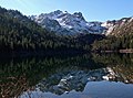
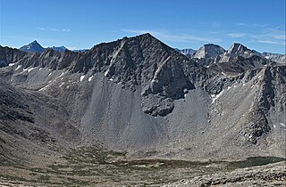
Mount Baldwin is a 12,614-foot-elevation (3,845-meter) mountain summit located in the Sierra Nevada mountain range in Mono County of northern California, United States. It is situated in the John Muir Wilderness on land managed by Inyo National Forest. It is four miles north of Red and White Mountain, and approximately 10.5 miles (16.9 km) southeast of the community of Mammoth Lakes. The nearest higher neighbor is Red Slate Mountain, 2 miles (3.2 km) to the south-southwest. Baldwin ranks as the 257th highest summit in California. Topographic relief is significant as the east aspect rises 3,775 feet above McGee Canyon in 1.5 mile. The first ascent of the summit was made July 2, 1928, by Norman Clyde, who is credited with 130 first ascents, most of which were in the Sierra Nevada.

Pointless Peak, elevation 12,256 feet (3,736 m), is a mountain summit located in Inyo County of northern California, United States. Set one-half mile east of the crest of the Sierra Nevada mountain range, the peak is situated in the John Muir Wilderness on land managed by Inyo National Forest. It rises at the northern end of Little Lakes Valley, and is immediately west of Rock Creek Lake. Topographic relief is significant as the summit rises 2,550 feet above this lake in approximately one mile (1.6 km). Neighbors include Mount Starr, 2.5 miles to the south, and line parent Mount Huntington, 1.4 mile to the northwest. This landform is also known as "Mono Mesa", but neither name is official and it will remain unofficial so long as the USGS policy of not adopting new toponyms in designated wilderness areas remains in effect.
Graveyard Peak is an 11,539-foot-elevation (3,517 meter) mountain summit located in the Sierra Nevada mountain range in Fresno County of northern California, United States. It is situated in the John Muir Wilderness, on land managed by Sierra National Forest. Graveyard Peak ranks as the 535th-highest summit in California, and topographic relief is significant as the south aspect rises over 2,300 feet above Devils Bathtub in approximately one mile. It is two miles southeast of Silver Peak, five miles north of Lake Thomas A Edison, and approximately 13 miles (21 km) south of the community of Mammoth Lakes. The peak is set on Silver Divide, so precipitation runoff from the north side of this mountain drains into Fish Creek which is a tributary of the San Joaquin River, and from the south slope to Lake Thomas A Edison. The peak is most easily reached out of Lake Thomas Edison.
Mount Julius Caesar is a 13,213-foot-elevation mountain summit located on the crest of the Sierra Nevada mountain range in northern California, United States. It is situated in the John Muir Wilderness on the boundary that Sierra National Forest shares with Inyo National Forest, and along the common border shared by Fresno County with Inyo County. It is one mile southwest of line parent Bear Creek Spire, and 22 miles (35 km) west of the community of Bishop. Italy Pass is one-half mile immediately south of the summit, and Granite Park lies to the southeast. Mount Julius Caesar ranks as the 106th-highest summit in California. Topographic relief is significant as the summit rises 2,000 feet above Lake Italy in 0.7 miles (1.1 km).

Dicks Peak is a 9,974-foot-elevation (3,040 meter) mountain summit located in the Sierra Nevada mountain range in El Dorado County, California, United States. It is the third-highest peak in the Desolation Wilderness, and is set on land managed by Eldorado National Forest. It is situated six miles (9.7 km) south of Lake Tahoe, and approximately eight miles (13 km) west of the community of South Lake Tahoe. Topographic relief is significant as the west aspect rises over 2,300 feet above Rockbound Valley in approximately one mile. One-half mile east of the peak the Pacific Crest Trail and Tahoe Rim Trail traverse Dicks Pass, which provides an approach option for those climbing the peak. Inclusion on the Sierra Peaks Section peakbagging list generates climbing interest.

Mount Lewis is a 12,350-foot-elevation mountain summit located along the crest of the Sierra Nevada mountain range, in Mono County of northern California, United States. It is situated in the Ansel Adams Wilderness, on land managed by Inyo National Forest. The summit lies less than one mile outside of Yosemite National Park's eastern boundary, and some of the lower western slope lies within the park. The mountain rises 1.8 miles (2.9 km) southeast of Mono Pass, 1.5 miles (2.4 km) northeast of Parker Pass, and two miles north of Parker Peak, which is the nearest higher neighbor. Topographic relief is significant as it rises over 5,200 feet above Grant Lake in four miles which makes the mountain visible from Highway 395.

Fletcher Peak is an 11,410-foot-elevation (3,478 meter) mountain summit located in Yosemite National Park, in Mariposa County, California, United States. It is situated south of Tuolumne Meadows in the Cathedral Range which is a sub-range of the Sierra Nevada mountain range. The mountain rises one mile (1.6 km) south of Tuolumne Pass, 1.3 miles (2.1 km) northeast of proximate parent Vogelsang Peak and 1.8 miles (2.9 km) northwest of line parent Parsons Peak. Topographic relief is significant as the summit rises 1,250 feet above Fletcher Lake in 0.38 miles (0.61 km). Precipitation runoff from this landform drains south to the Merced River via Fletcher Creek.
Hawksbeak Peak is a mountain summit with an elevation of 11,134 feet (3,394 m) located on the crest of the Sierra Nevada mountain range, in northern California, United States. The granitic summit is situated on the common boundary shared by Yosemite National Park with Hoover Wilderness, as well as the common border of Mono County and Tuolumne County. This remote peak is set at the head of Thompson Canyon, approximately eight miles west of Twin Lakes and 17 miles southwest of Bridgeport, the nearest town. Topographic relief is significant as the west aspect rises over 1,300 feet in less than one-quarter mile. The class 5.10- West Face was first climbed in September 1989 by Alan Swanson and John Nye. This landform's toponym has been officially adopted by the U.S. Board on Geographic Names.

Stevens Peak is a 10,059-foot-elevation (3,066 meter) mountain summit located in Alpine County, California, United States.

Elephants Back is a 9,585-foot-elevation (2,922 meter) mountain summit located in Alpine County, California, United States.

Hawkins Peak is a 10,024-foot-elevation (3,055 meter) mountain summit located in Alpine County, California, United States.

Donner Peak is an 8,019-foot-elevation (2,444 meter) summit in Placer County, California, United States.

Mount Lincoln is an 8,383-foot-elevation (2,555 meter) mountain summit in Placer County, California, United States.

Mount Judah is an 8,243-foot-elevation (2,512 meter) mountain summit in Placer County, California, United States.

Sawmill Point is a 9,429-foot-elevation (2,874 meter) mountain summit located in Inyo County, California. It is situated 2.6 miles east of the crest of the Sierra Nevada mountain range, in the John Muir Wilderness, on land managed by Inyo National Forest. It is also 10.5 miles (16.9 km) northwest of the community of Independence, and 2.6 miles (4.2 km) east of proximate parent Colosseum Mountain. Topographic relief is significant as the summit rises 4,770 feet above Owens Valley in two miles. The Sawmill Pass Trail traverses the east and south slopes of the peak, providing an approach option, and access to the John Muir Trail.

Tinker Knob is an 8,949-foot-elevation (2,728 meter) mountain summit in Placer County, California, United States.

Tamarack Peak is a 9,897-foot-elevation mountain summit located in Washoe County, Nevada, United States.

Rose Knob Peak is a 9,710-foot-elevation mountain summit located in Washoe County, Nevada, United States.

Twin Peaks is an 8,878-foot-elevation (2,706 meter) double summit mountain in Placer County, California, United States.

Granite Dome is a 10,320-foot-elevation (3,146 meter) mountain summit located in Tuolumne County, California, United States.