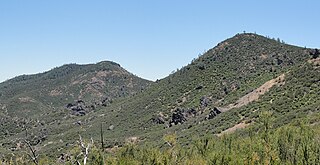
Chalone identifies the first American Viticultural Area (AVA) established in Monterey County, California straddling its border with San Benito County where it is the second established AVA. Chalone viticultural area is located in the Gabilan Mountains east of Soledad. It was recognized by the Bureau of Alcohol, Tobacco and Firearms (ATF) effective on July 14, 1982 after reviewing the petition submitted by the Gavilan Vineyards, Inc. to establish a viticultural area in Monterey and San Benito counties to be named "The Pinnacles." The area encompasses 8,640 acres (14 sq mi) and the proposed name was recognition of the nearby Chalone peaks.

Washington wine is a wine produced from grape varieties grown in the U.S. state of Washington. Washington ranks second in the United States in the production of wine. By 2017, the state had over 55,000 acres (220 km2) of vineyards, a harvest of 229,000 short tons (208,000 t) of grapes, and exports going to over 40 countries around the world from the 940+ wineries located in the state. While there are some viticultural activities in the cooler, wetter western half of the state, the majority (99.9%) of wine grape production takes place in the shrub-steppe eastern half. The rain shadow of the Cascade Range leaves the Columbia River Basin with around 8 inches (200 mm) of annual rain fall, making irrigation and water rights of paramount interest to the Washington wine industry. Viticulture in the state is also influenced by long sunlight hours and consistent temperatures.

Santa Maria Valley is an American Viticultural Area (AVA) which straddles the boundary of Santa Barbara and San Luis Obispo counties in California's multi-county Central Coast AVA. It was established on August 5, 1981, by the Bureau of Alcohol, Tobacco, Firearms and Explosives (ATF) as California's second oldest AVA. A portion of the AVA crosses the Cuyama River into the southernmost corner of San Luis Obispo County. The east–west orientation of the 152.3 square miles with a wide, open valley and rolling hills means cool winds and fog flow in freely from the Pacific Ocean, settling most noticeably in lower-lying areas. The result is a mild Mediterranean climate that lengthens the growing season and contributes to the eventual sugar/acid balance in the grapes from Santa Maria Valley's 7,500 acres (3,000 ha) cultivated vineyards. On January 28, 2011, the AVA was granted an 29.4 square miles expansion to its southern boundary.
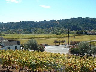
Sonoma County wine is wine made in Sonoma County, California, in the United States.

Santa Clara Valley is an American Viticultural Area] (AVA) located mostly in Santa Clara County, California. The area served an important role in the early history of California wine and was home to the pioneer winemakers Paul Masson and Charles Lefranc. It was established on April 27, 1989 by the Bureau of Alcohol, Tobacco and Firearms (ATF), Treasury after evaluating the petition proposing a viticultural area in Santa Clara, San Benito, San Mateo and Alameda Counties that extends from lower San Francisco Bay with the cities of San Jose, Santa Clara, Menlo Park, Mountain View and Fremont toward the southern boundary near Gilroy and Morgan Hill, outlining the viticultural area named "Santa Clara Valley." It includes the historic winegrowing areas of Santa Clara County not already within the [Santa Cruz Mountains viticultural area, plus the area near Mission San José in Alameda County and a small part of San Benito County. Santa Clara Valley encompasses the established viticultural areas, Pacheco Pass and San Ysidro District.
The Mendocino Ridge AVA is a coastal, cool climate and high altitude American Viticultural Area located entirely within the coastal zone of Mendocino County, California. The boundaries of the AVA encompass the coastal ridges adjacent to the Pacific Ocean that reach inland toward the Anderson Valley. Roughly 36 miles of the southernmost portion of the Mendocino Coast make up the western boundary of the AVA, with the Sonoma County line as the southern boundary, the Navarro River as the northern boundary and Anderson Valley as the inland boundary running northwest–southeast. The Mendocino Ridge AVA "is essentially a northern extension of the true Sonoma Coast viticultural area." However, the Mendocino Ridge AVA designation is unique in that it is limited by elevation, reserved only for vineyards at or above 1200 feet. This is why the Mendocino Ridge AVA has been nicknamed "Islands in the Sky®," because the vineyards sitting at 1200 feet or higher are often perched above thick fog moving inland from the Pacific Ocean blanketing the coast and the valleys between the ridge tops, making the tips of the mountains look like islands protruding from a sea of fog. In this overlapping, "[t]he Mendocino Ridge AVA floats above the Anderson Valley and Mendocino appellations." Mendocino Ridge is the only non-contiguous AVA in the United States; all others are contiguous landmasses with all vineyards inside the boundaries designated as part of the AVA, whereas Mendocino Ridge in comparison only includes the higher altitude growing sites. "There are 262,400 acres within the outer boundaries of the Mendocino Ridge viticultural area, but the actual viticultural area encompasses only 87,466 acres which lie above 1,200 feet elevation. Of these 87,466 acres, approximately 1,500 to 2,000 acres of the ridge tops are suitable for vineyards. The side-slopes are very steep and covered with timber, making them unfit for planting". Estimates of planted acres range from 233 to 410, which accounts for about 0.3% of the total area. These planted acres are scattered among 16 remote vineyards.
Arroyo Grande Valley is an American Viticultural Area (AVA) located in San Luis Obispo County, California approximately 12 miles (19 km) southeast of the county seat San Luis Obispo. Arroyo Grande Valley was recognized on February 5, 1990 by the Bureau of Alcohol, Tobacco, Firearms and Explosives (ATF) as the state's 60th AVA based on the petition filed in 1987 by Don Talley of Talley Vineyards and William S. Greenough of Saucelito Canyon Vineyard for the establishment of the "Arroyo Grande Valley" viticultural area in San Luis Obispo County. The 16 miles (26 km) long, approximately 67 square miles valley appellation benefits from its east-northeast orientation allowing the breeze from the Pacific Ocean to moderate the climate of the area. The valley is divided by a fog line produced by the cool maritime layer where Zinfandel, Petite Sirah and Rhône varietals are grown on the higher elevations near Lopez Lake and the cooler mid-valley vineyards being home to Chardonnay and Pinot noir. On April 8, 2022, the Alcohol and Tobacco Tax and Trade Bureau (TTB) approved the designation of the expansive San Luis Obispo (SLO) Coast AVA overlapping the boundaries of Edna Valley and Arroyo Grande Valley viticultural areas because they share common features. However, these two previously established areas still have unique characteristics to retain their viticultural area distinctions within SLO Coast. Edna Valley lies immediately to the northwest, the Los Padres National Forest straddles the north leg boundary, the Santa Maria Valley AVA lies to the southeast of Arroyo Grande Valley, and the Pacific Ocean communities of Oceano, Grover City and Arroyo Grande abut its southwestern border.

Santa Cruz Mountains AVA is an American Viticultural Area (AVA) centered on the Santa Cruz Mountains. Its territory spans three California counties, Santa Clara, Santa Cruz and San Mateo and was established January 4, 1982 by the Bureau of Alcohol, Tobacco and Firearms (ATF), Treasury. Santa Cruz Mountains AVA was among the first AVA to be defined by its mountainous topography. Based on elevation, it largely follows the fog line along the coast, extending down to 800 feet (240 m) on the eastern slope toward San Francisco Bay, 400 feet (120 m) on the western slope to the Pacific Ocean and extending along the ridge crest line at 3,000 feet (910 m) elevation plus.
The Chiles Valley is an American Viticultural Area (AVA) located in Napa County, California and a sub-region within Napa Valley AVA. It was established as California's 81st AVA by the Bureau of Alcohol, Tobacco and Firearms (ATF) on April 19, 1999 after the ATF received the petition from Mr. Volker Eisele, owner of the Volker Eisele Vineyard and Winery proposing a new viticultural area in Napa County to be known as "Chiles Valley District".

The Spring Mountain District AVA is an American Viticultural Area located in the Napa Valley AVA in California. Spring Mountain District AVA was officially established as an American Viticulture Area in 1993. Encompassed within its bounds are about 8,600 acres (3,480 ha), of which about 1,000 acres (400 ha) are planted to vineyards. Given the small crop yields on hillsides, the region represents less than 2% of Napa Valley wine. Currently the region has just over 30 winegrowers.

The El Dorado AVA is an American Viticultural Area located in El Dorado County, California, United States. Wine grape growers in the region produce a large diversity of varietals, notable varietals are Zinfandel, Barbera, Cabernet Sauvignon, Merlot and Petite Sirah and there are significant plantings of Rhône varietals. Located in the foothills of the Sierra Nevada mountains, vineyards are found primarily at elevations between 600 feet (183 m) and 3,500 feet (1,067 m) above sea level and some of the historic and revered vineyards are planted above 2,000 feet (610 m) elevation. The region benefits from the cool breezes that come off the mountains and push hot air off the vines and down to the valley. The soils of the region are magma based with high levels of acidity.
California Shenandoah Valley is an American Viticultural Area (AVA) located within portions of Amador County and El Dorado County, California. The area was established on January 27, 1983 by the Bureau of Alcohol, Tobacco, Firearms and Explosives (ATF), Treasury after approving the petition from the Amador County Wine Grape Growers Association proposing a viticultural area in Amador County, California, to be known as "Shenandoah Valley." It lies within the vast multi-county Sierra Foothills viticultural area boundaries and borders the northwest boundary of Fiddletown viticultural area which received recognition later the same year. In the petition, the area consists of approximately 10,000 acres (16 sq mi) with about1,200 acres (486 ha) under vine. The petition requested ATF for the Shenandoah Valley viticultural area to be situated to the north and west of Fiddletown, and to the north and east of Plymouth.
The Fair Play AVA is an American Viticultural Area in El Dorado County, California, United States. It is entirely contained within the boundaries of the El Dorado AVA and the Sierra Foothills AVA. The boundaries of the Fair Play AVA include rolling hills at elevations between 2,000 feet (610 m) and 3,000 feet (914 m) above sea level, making it the California appellation with the second highest average elevation after the Squaw Valley-Miramonte appellation. The soils are decomposed granite as part of the Sierra Nevada Foothills region, and the area is within the Cosumnes River watershed. The most popular red wine grape variety is Zinfandel, although varieties popular in southern Rhone Valley France and Italy, such as Syrah, Grenache, Mourvedre, Sangiovese and Barbera are quite commonly planted here. White wine is less popular in this AVA, but significant plantings of Viognier and Grenache Blanc, along with Chardonnay are the more popular white varietals.

Fiddletown is an American Viticultural Area (AVA) in Amador County, California, United States. The area was estabished on November 3, 1983 by the Bureau of Alcohol, Tobacco and Firearms (ATF), Treasury after reviewing the petition submitted from the Fiddletown Wine Grape Growers in Amador County to establish a viticultural area to be known as "Fiddletown." The region was first settled in 1849, during the California Gold Rush. Settlers who stayed in the area eventually planted grape vines, which became abundant by the end of the nineteenth century. Most of the vineyards in the Fiddletown AVA are located in the south and west portion of the region on Sierra Nevada slopes between 1,500 to 2,500 feet (457–762 m) above sea level. About 20% of the wine produced in Amador County comes from Fiddletown viticultural area.
North Yuba is an American Viticultural Area (AVA) located in Yuba County, California, United States. It was established on August 30, 1985 by the Bureau of Alcohol, Tobacco, Firearms and Explosives (ATF), Treasury after approving the submitted petition by Karl Werner and James R. Bryant, officers of Renaissance Vineyard and Winery, Inc. in Oregon House. They petitioned ATF for the establishment of a viticultural area to be named "North Yuba.”
Lake County wine is a appellation that designates wine made from grapes grown mostly in Lake County, California and located north of Napa County. Although each region within Lake County has unique viticultural attributes, all are influenced by Clear Lake, the largest inland body of water in California. County names in the United States automatically qualify as legal appellations of origin for wine produced from grapes grown in that county and do not require registration with the Alcohol and Tobacco Tax and Trade Bureau (TTB). TTB was created in January 2003, when the Bureau of Alcohol, Tobacco and Firearms, or ATF, was extensively reorganized under the provisions of the Homeland Security Act of 2002.

San Benito is an American Viticultural Area (AVA) located in San Benito County, California. It was established on November 4, 1987 by the Bureau of Alcohol, Tobacco and Firearms (ATF), Treasury after evaluating the petition submitted by Almaden Vineyards, a winery and grape grower in the area, proposing that a portion of San Benito County be established as a viticultural area to be known as "San Benito."

Santa Barbara County wine is an appellation that designates wine made from grapes grown mostly in Santa Barbara County, California which is located approximately 50 miles (80 km) north of Los Angeles County. County names in the United States automatically qualify as legal appellations of origin for wine produced from grapes grown in that county and do not require registration with the Alcohol and Tobacco Tax and Trade Bureau (TTB) of the Treasury Department. TTB was created in January 2003, when the Bureau of Alcohol, Tobacco and Firearms, or ATF, was extensively reorganized under the provisions of the Homeland Security Act of 2002.

San Luis Obispo (SLO) County wine is a appellation that designates wine made from grapes grown in San Luis Obispo (SLO) County, California which is sandwiched between Santa Barbara County to the south and Monterey County at the northern boundary on the Pacific coast. Its location sits halfway between the cities of San Francisco and Los Angeles on the north–south axis of U.S. Route 101 and Pacific Coast Highway (PCH). The county lies entirely within the Central Coast viticultural area. County names in the United States automatically qualify as legal appellations of origin for wine produced from grapes grown in that county and do not require registration with the Alcohol and Tobacco Tax and Trade Bureau (TTB) of the Treasury Department. TTB was created in January of 2003, when the Bureau of Alcohol, Tobacco and Firearms, or ATF, was extensively reorganized under the provisions of the Homeland Security Act of 2002.

Monterey County wine is a appellation that designates wine made from grapes grown in Monterey County, California which lies entirely within the expansive multi-county Central Coast viticultural area. County names in the United States automatically qualify as legal appellations of origin for wine produced from grapes grown in that county and do not require registration with the Alcohol and Tobacco Tax and Trade Bureau (TTB). TTB was created in January 2003, when the Bureau of Alcohol, Tobacco and Firearms, or ATF, was extensively reorganized under the provisions of the Homeland Security Act of 2002.
