Vallecito, California

Last updated
Vallecito
Calaveras County California Incorporated and Unincorporated areas Vallecito Highlighted.svg
Location in Calaveras County and the state of California
Usa edcp location map.svg
Red pog.svg
Vallecito
Location in the United States
Coordinates: 38°05′25″N120°28′25″W / 38.09028°N 120.47361°W / 38.09028; -120.47361
Country Flag of the United States.svg  United States
State Flag of California.svg  California
County Calaveras
Area
[1]
  Total8.566 sq mi (22.184 km2)
  Land8.561 sq mi (22.172 km2)
  Water0.005 sq mi (0.012 km2)  0.05%
Elevation
1,762 ft (537 m)
Population
 (2010)
  Total442
  Density52/sq mi (20/km2)
Time zone UTC-8 (Pacific (PST))
  Summer (DST) UTC-7 (PDT)
ZIP codes
95229, 95251
Area code 209
FIPS code 06-81652
GNIS feature IDs 268654, 2409394
Reference no.273

Vallecito (Spanish for "Little Valley") is a census-designated place (CDP) in Calaveras County, California, United States. The population was 442 at the 2010 census, up from 427 at the 2000 census. The town is registered as California Historical Landmark #273. [2] Nearby is Moaning Cavern, the largest cave chamber in California, which the Miwok Indians used as a burial ground.

Contents

History

Vallecito was one of California's important early-day mining towns. Gold was discovered here by the Murphy brothers in 1849, and it was originally called "Murphys Diggings," which became "Murphys Old Diggings" when they moved on to greener pastures at "Murphys New Diggings" (which became the town of Murphys). The town was revitalized in 1852 when extremely rich deposits of gold were discovered running practically through the center of town. A post office was established in 1854, which is still in use today.

The Vallecito Bell, cast at Troy, New York in 1853, was brought around Cape Horn. It was purchased from the ship with funds contributed by early-day residents and brought to Vallecito to be erected in a large oak tree in 1854. It was used to call the people together until February 16, 1939, when a severe wind blew the old tree down.

The first post office opened in 1854 as Vallicita; the town's name was changed to Vallecito in 1940. [3]

Geography

According to the United States Census Bureau, the CDP has a total area of 8.6 square miles (22 km2), 99.95% of it land.

Demographics

2010

The 2010 United States Census [4] reported that Vallecito had a population of 442. The population density was 51.6 inhabitants per square mile (19.9/km2). The racial makeup of Vallecito was 398 (90.0%) White, 0 (0.0%) African American, 6 (1.4%) Native American, 11 (2.5%) Asian, 1 (0.2%) Pacific Islander, 5 (1.1%) from other races, and 21 (4.8%) from two or more races. Hispanic or Latino of any race were 33 persons (7.5%).

The Census reported that 442 people (100% of the population) lived in households, 0 (0%) lived in non-institutionalized group quarters, and 0 (0%) were institutionalized.

There were 193 households, out of which 53 (27.5%) had children under the age of 18 living in them, 98 (50.8%) were opposite-sex married couples living together, 25 (13.0%) had a female householder with no husband present, 6 (3.1%) had a male householder with no wife present. There were 9 (4.7%) unmarried opposite-sex partnerships, and 0 (0%) same-sex married couples or partnerships. 54 households (28.0%) were made up of individuals, and 21 (10.9%) had someone living alone who was 65 years of age or older. The average household size was 2.29. There were 129 families (66.8% of all households); the average family size was 2.77.

The population was spread out, with 84 people (19.0%) under the age of 18, 22 people (5.0%) aged 18 to 24, 94 people (21.3%) aged 25 to 44, 165 people (37.3%) aged 45 to 64, and 77 people (17.4%) who were 65 years of age or older. The median age was 47.7 years. For every 100 females, there were 87.3 males. For every 100 females age 18 and over, there were 82.7 males.

There were 217 housing units at an average density of 25.3 per square mile (9.8/km2), of which 193 were occupied, of which 138 (71.5%) were owner-occupied, and 55 (28.5%) were occupied by renters. The homeowner vacancy rate was 0.7%; the rental vacancy rate was 6.8%. 321 people (72.6% of the population) lived in owner-occupied housing units and 121 people (27.4%) lived in rental housing units.

2000

As of the census [5] of 2000, there were 427 people, 183 households, and 120 families residing in the CDP. The population density was 49.8 inhabitants per square mile (19.2/km2). There were 195 housing units at an average density of 22.8 per square mile (8.8/km2). The racial makeup of the CDP was 95.55% White, 0.23% Black or African American, 3.04% Native American, 0.47% Asian, 0.47% from other races, and 0.23% from two or more races. 1.87% of the population were Hispanic or Latino of any race.

There were 183 households, out of which 26.8% had children under the age of 18 living with them, 54.1% were married couples living together, 8.7% had a female householder with no husband present, and 34.4% were non-families. 26.2% of all households were made up of individuals, and 9.3% had someone living alone who was 65 years of age or older. The average household size was 2.33 and the average family size was 2.83.

In the CDP, the population was spread out, with 22.2% under the age of 18, 5.6% from 18 to 24, 25.8% from 25 to 44, 32.8% from 45 to 64, and 13.6% who were 65 years of age or older. The median age was 44 years. For every 100 females, there were 102.4 males. For every 100 females age 18 and over, there were 97.6 males.

The median income for a household in the CDP was $36,875, and the median income for a family was $32,917. Males had a median income of $46,250 versus $37,917 for females. The per capita income for the CDP was $18,779. About 11.6% of families and 16.6% of the population were below the poverty line, including 32.0% of those under age 18 and 8.2% of those age 65 or over.

Politics

In the state legislature, Vallecito is in the 8th Senate District , represented by Democrat Angelique Ashby, [6] and the 5th Assembly District , represented by Republican Joe Patterson. [7] Federally, Vallecito is in California's 4th congressional district , represented by Democrat Mike Thompson. [8]

See also

Related Research Articles

<span class="mw-page-title-main">Fairview, California</span> CDP in California, United States

Fairview is a census-designated place (CDP) in Alameda County, California, United States. It borders on the city of Hayward and the census-designated place of Castro Valley. The population was 11,341 at the 2020 census.

<span class="mw-page-title-main">Murphys, California</span> Census designated place in California, United States

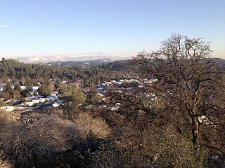
Murphys, originally Murphys New Diggings then Murphy's Camp, is an unincorporated village located in the foothills of the Sierra Nevada mountains in Calaveras County, California, United States. The population was 2,213 at the 2010 census, up from 2,061 at the 2000 census.

<span class="mw-page-title-main">Riverdale, California</span> Census-designated place in California, United States

Riverdale is a census-designated place (CDP) in Fresno County, California, United States. The population was 3,153 at the 2010 census, up from 2,416 at the 2000 census. Riverdale is located 23 miles (37 km) south of Fresno, at an elevation of 223 ft (68 m).

<span class="mw-page-title-main">Shaver Lake, California</span> Census-designated place in California, United States

Shaver Lake is a census-designated place (CDP) in Fresno County, California, United States. The population was 634 at the 2010 census, down from 705 at the 2000 census. Shaver Lake is on the southwest end of the lake of the same name, 10 miles (16 km) east of New Auberry, at an elevation of 5,627 ft (1,715 m). The name honors C.B. Shaver, founder of the Fresno Flume and Irrigation Company that built the dam, creating the lake. The lake served as a mill pond for the Shaver Sawmill and the source for a flume that ran 65 miles (105 km) to Clovis. The original town of Shaver was buried under the lake when the Thomas A. Edison Company purchased and enlarged the lake in 1919.

<span class="mw-page-title-main">Mesa, California</span> Census-designated place in California, United States

Mesa is a census-designated place (CDP) in Inyo County, California, United States. The population was 251 at the 2010 census, up from 214 at the 2000 census.

<span class="mw-page-title-main">Mountain Mesa, California</span> Census-designated place in California, United States

Mountain Mesa is a census-designated place (CDP) in Kern County, California, United States. Mountain Mesa is located 2 miles (3.2 km) west of South Lake at an elevation of 2,641 feet (805 m). The population was 777 at the 2010 census, up from 716 at the 2000 census.

<span class="mw-page-title-main">Squirrel Mountain Valley, California</span> Census-designated place in California, United States

Squirrel Mountain Valley is a census-designated place (CDP) in the southern Sierra Nevadas, in Kern County, California, United States. Squirrel Mountain Valley is located in the Lake Isabella area 5 miles (8 km) northeast of Bodfish, at an elevation of 2,900 feet (883.9 m). The population was 547 at the 2010 census, up from 498 at the 2000 census.

<span class="mw-page-title-main">Citrus, California</span> Census-designated place in California, United States

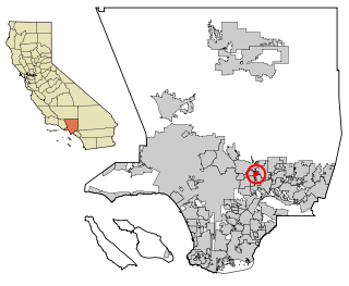
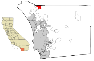
Citrus is a census-designated place (CDP) in Los Angeles County, California, United States. It is located in the San Gabriel Valley between Azusa to the north and west, Glendora to the east, and Covina to the south. The population was 10,866 at the 2010 census, up from 10,581 at the 2000 census. Citrus is named after Citrus Avenue, which passes through the community.

<span class="mw-page-title-main">East San Gabriel, California</span> Census-designated place in California, United States

East San Gabriel is a census-designated place (CDP) in Los Angeles County, California, United States. The population was 14,874 at the 2010 census, up from 14,512 at the 2000 census.

<span class="mw-page-title-main">Parksdale, California</span> Census-designated place in California, United States

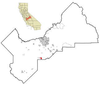
Parksdale is a census-designated place (CDP) in Madera County, California, United States. It is part of the Madera Metropolitan Statistical Area. The population was 3,234 at the 2020 census, up from 2,621 in 2010.

<span class="mw-page-title-main">Tamalpais-Homestead Valley, California</span> Census-designated place in California, United States

Tamalpais-Homestead Valley is a census-designated place (CDP) in Marin County, California, United States. The population was 11,492 at the 2020 census.

<span class="mw-page-title-main">North Auburn, California</span> Census-designated place in California, United States

North Auburn is a census-designated place (CDP) in Placer County, California, United States. It is part of the Sacramento–Arden-Arcade–Roseville Metropolitan Statistical Area. The population was 13,452 at the 2020 census.

<span class="mw-page-title-main">Indian Falls, California</span> Census-designated place in California, United States

Indian Falls is a census-designated place (CDP) in Plumas County, California, United States. The population was 54 at the 2010 census, up from 37 at the 2000 census.

<span class="mw-page-title-main">Tobin, California</span> Census-designated place in California, United States

Tobin is a census-designated place (CDP) in Plumas County, California, United States. The population was 12 at the 2010 census, up from 11 at the 2000 census.

<span class="mw-page-title-main">El Cerrito, Riverside County, California</span> Census-designated place in Riverside County, California, United States

El Cerrito is a census-designated place (CDP) in Riverside County, California, United States. It is an unincorporated area mostly surrounded by the city of Corona. The population was 5,100 at the 2010 census, up from 4,590 at the 2000 census.

<span class="mw-page-title-main">Big River, California</span> Census-designated place in California, United States

Big River is a census-designated place (CDP) in San Bernardino County, California, United States. The population was 1,327 at the 2010 census, up from 1,266 at the 2000 census.

<span class="mw-page-title-main">Lake San Marcos, California</span> Census-designated place in California, United States

Lake San Marcos is a census-designated place (CDP) in the North County region of the San Diego metropolitan area. It is nominally independent of San Marcos proper, but functionally subservient to the city.

<span class="mw-page-title-main">Rainbow, California</span> Census designated place in California, United States

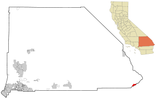
Rainbow is a census designated place (CDP) in northern San Diego County in the U.S. state of California. The population was 1,832 at the 2010 census, down from 2,026 at the 2000 census.

<span class="mw-page-title-main">Traver, California</span> Census-designated place in California, United States

Traver is a census-designated place (CDP) in Tulare County, California, United States. The population was 713 at the 2010 census, down from 732 at the 2000 census.

<span class="mw-page-title-main">Woodville, California</span> Census-designated place in California, United States

Woodville is a census-designated place (CDP) in Tulare County, California, United States. The population was 1,740 at the 2010 census, up from 1,678 at the 2000 census.

References

  1. "2010 Census U.S. Gazetteer Files – Places – California". United States Census Bureau.
  2. "Vallecito". Office of Historic Preservation, California State Parks. Retrieved 2012-10-06.
  3. Durham, David L. (1998). California's Geographic Names: A Gazetteer of Historic and Modern Names of the State. Clovis, Calif.: Word Dancer Press. p. 841. ISBN   1-884995-14-4.
  4. "2010 Census Interactive Population Search: CA - Vallecito CDP". U.S. Census Bureau. Archived from the original on July 15, 2014. Retrieved July 12, 2014.
  5. "U.S. Census website". United States Census Bureau . Retrieved 2008-01-31.
  6. "Senators". State of California. Retrieved March 21, 2013.
  7. "Members Assembly". State of California. Retrieved March 21, 2013.
  8. "California's 4th Congressional District - Representatives & District Map". Civic Impulse, LLC. Retrieved March 2, 2013.