Mokelumne Hill, California

Last updated

Mokelumne Hill
Main Street building in historic Mokelumne Hill, California LCCN2013634004.tif
Main Street building
Calaveras County California Incorporated and Unincorporated areas Mokelumne Hill Highlighted.svg
Location in Calaveras County and the state of California
Usa edcp location map.svg
Red pog.svg
Mokelumne Hill
Location in the United States
Coordinates: 38°18′02″N120°42′23″W / 38.30056°N 120.70639°W / 38.30056; -120.70639
Country Flag of the United States.svg  United States
State Flag of California.svg  California
County Calaveras
Area
[1]
  Total3.082 sq mi (7.981 km2)
  Land3.079 sq mi (7.974 km2)
  Water0.003 sq mi (0.007 km2)  0.09%
Elevation
[2]
1,473 ft (449 m)
Population
  Total646
  Density210/sq mi (81/km2)
Time zone UTC-8 (Pacific)
  Summer (DST) UTC-7 (PDT)
ZIP code
95245
Area code 209
FIPS code 06-48480
GNIS feature IDs 228901, 2408855
Reference no.269

Mokelumne Hill (Mokelumne, Miwok for "People of the Fish Net") is a census-designated place (CDP) in Calaveras County, California, United States. The population was 646 at the 2010 census, down from 774 at the 2000 census. It is commonly referred to as "Moke Hill" by locals. The town takes its name from the neighboring Mokelumne River, which in turn is Miwok for the "people of Mokel," the likely name of a Native American village in the area.

Contents

History

Mokelumne Hill was one of the richest gold mining towns in California. Founded in 1848 by a group of Oregonians, the placers were so rich that the miners risked starvation rather than head to Stockton to replenish their supplies (one finally did and made it rich by becoming a merchant). Soon after, gold was discovered in the nearby hills, so much so that miners were restricted to claims of 16 square feet (1.5 m2), and yet many of those claims were reported to have paid up to $20,000.

By 1850 the town was one of the largest in the area. Its population reached as high as 15,000 with people of all nationalities, particularly Americans, Frenchmen, Germans, Spaniards, Chileans, Mexicans, and Chinese. Besides racial tensions, the easy gold attracted criminal elements, and the town gained a reputation as one of the bawdiest in the area. Notorious bandit Joaquin Murrieta is said to have been a frequent visitor to the gambling venues. Violence was a major problem as well. In 1851, there was at least one homicide a week for seventeen consecutive weeks.

A June, 1851, incident in Mokelumne Hill has been dubbed California's French Revolution, or French War, by some historians. The previous year the State Legislature had passed the Foreign Miners' Tax Act of 1850. Frenchmen in the area revolted and refused to pay the tax. The Sheriff, also the Tax Collector, summoned a large posse to enforce the act, but the Frenchmen raised the French flag and proclaimed their independence. This prompted the Governor to direct a battalion of militia, commanded by William D. Bradshaw, to suppress the revolt. Disaster was averted when Bradshaw negotiated with the Frenchmen to stand down. [3] [4]

Also in 1851, the first post office was established in the town, [5] and in 1852 the town became the county seat. In the same year a vigilance committee was formed and the worst of the crime was eliminated.

By the 1860s the gold started to run out and the town's population and importance diminished. When San Andreas became the new county seat in 1866, Mokelumne Hill's status declined even further. The town today is a quiet place, with much tourism due to its historic status. From 1959 to 1977 Mokelumne Hill was home to Lucile S. Davidson, known as "the shoe lady of Mokelumne Hill". She was in The Stockton 'Record' and later in the Guinness Book of World Records for having the largest privately owned glass shoe collection in the world.

Mokelumne Hill is registered as California Historical Landmark #269. [6]

Landmarks

Home built in 1852 Edith Irvine home Mok Hill.webp
Home built in 1852

Geography

According to the United States Census Bureau, the CDP has a total area of 3.1 square miles (8.0 km2), over 99% of it land.

Climate

According to the Köppen Climate Classification system, Mokelumne Hill has a hot-summer Mediterranean climate, abbreviated "Csa" on climate maps. [9]

Demographics

At the 2010 census Mokelumne Hill had a population of 646. The population density was 209.6 inhabitants per square mile (80.9/km2). The racial makeup of Mokelumne Hill was 571 (88.4%) White, 3 (0.5%) African American, 12 (1.9%) Native American, 4 (0.6%) Asian, 0 (0.0%) Pacific Islander, 26 (4.0%) from other races, and 30 (4.6%) from two or more races. Hispanic or Latino of any race were 66 people (10.2%). [10]

The whole population lived in households, no one lived in non-institutionalized group quarters and no one was institutionalized.

There were 299 households, 63 (21.1%) had children under the age of 18 living in them, 129 (43.1%) were opposite-sex married couples living together, 31 (10.4%) had a female householder with no spouse present, 14 (4.7%) had a male householder with no spouse present. There were 24 (8.0%) unmarried opposite-sex partnerships, and 5 (1.7%) same-sex married couples or partnerships. 99 households (33.1%) were one person and 38 (12.7%) had someone living alone who was 65 or older. The average household size was 2.16. There were 174 families (58.2% of households); the average family size was 2.71.

The age distribution was 102 people (15.8%) under the age of 18, 39 people (6.0%) aged 18 to 24, 119 people (18.4%) aged 25 to 44, 245 people (37.9%) aged 45 to 64, and 141 people (21.8%) who were 65 or older. The median age was 51.4 years. For every 100 females, there were 88.9 males. For every 100 females age 18 and over, there were 84.4 males.

There were 354 housing units at an average density of 114.9 per square mile (44.4/km2),of which 299 were occupied, 205 (68.6%) by the owners and 94 (31.4%) by renters. The homeowner vacancy rate was 2.8%; the rental vacancy rate was 18.3%. 447 people (69.2% of the population) lived in owner-occupied housing units and 199 people (30.8%) lived in rental housing units.

Politics

In the state legislature, Mokelumne Hill is in the 8th Senate District , represented by Democrat Angelique Ashby, [11] and the 5th Assembly District , represented by Republican Joe Patterson. [12] Federally, Mokelumne Hill is in California's 4th congressional district , represented by Democrat Mike Thompson. [13]

Related Research Articles

<span class="mw-page-title-main">Amador County, California</span> County in California, United States

Amador County is a county located in the U.S. state of California, in the Sierra Nevada. As of the 2020 census, the population was 40,474. The county seat is Jackson. Amador County, located within California's Gold Country, is known as "The Heart of the Mother Lode". There is a substantial viticultural industry in the county.

<span class="mw-page-title-main">Calaveras County, California</span> County in California, United States

Calaveras County, officially the County of Calaveras, is a county in both the Gold Country and High Sierra regions of the U.S. state of California. As of the 2020 census, the population was 45,292. The county seat is San Andreas. Angels Camp is the county's only incorporated city. Calaveras is Spanish for "skulls"; the county was reportedly named for the remains of Native Americans discovered by the Spanish explorer Captain Gabriel Moraga.

<span class="mw-page-title-main">Jackson, California</span> City in California, United States

Jackson is a city in and the county seat of Amador County, California. Its population was 4,651 at the 2010 census, up from 3,989 at the 2000 census. The city is accessible by both State Route 49 and State Route 88.

<span class="mw-page-title-main">Avery, California</span> Census-designated place in California, United States

Avery is a census-designated place (CDP) in Calaveras County, California, United States. The population was 646 at the 2010 census, down from 672 at the 2000 census. Avery is located on State Route 4 and is home to the oldest continually operating hotel in the county, the Avery Hotel Restaurant & Saloon. Built in 1853, it was known as the "Half Way House," being located between Murphys, Arnold, and Calaveras Big Trees State Park.

<span class="mw-page-title-main">Copperopolis, California</span> Census-designated place in California, United States

Copperopolis is an unincorporated town and census-designated place (CDP) in Calaveras County, California, United States. The population was 3,671 at the 2010 census, up from 2,363 at the 2000 census. The town is located along State Route 4 and is registered as California Historical Landmark #296.

<span class="mw-page-title-main">Mountain Ranch, California</span> Census-designated place in California, United States

Mountain Ranch is a census-designated place (CDP) in Calaveras County, California, United States. The population was 1,628 at the 2010 census, up from 1,557 at the 2000 census. The town is registered as California Historical Landmark #282. The town center is quite small with fewer than 50 people living in it. The 5 mile square area surrounding the town accounts for the balance of the population.

<span class="mw-page-title-main">Murphys, California</span> Census designated place in California, United States

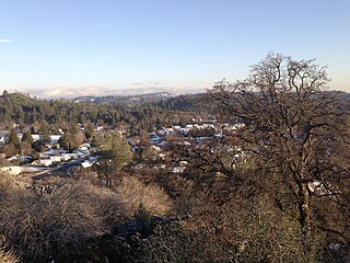
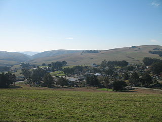
Murphys, originally Murphys New Diggings then Murphy's Camp, is an unincorporated village located in the foothills of the Sierra Nevada mountains in Calaveras County, California, United States. The population was 2,213 at the 2010 census, up from 2,061 at the 2000 census.

<span class="mw-page-title-main">Rail Road Flat, California</span> Census-designated place in California, United States

Rail Road Flat is a census-designated place (CDP) in Calaveras County, California, United States. The population was 475 at the 2010 census, down from 549 at the 2000 census.

<span class="mw-page-title-main">San Andreas, California</span> Census-designated place in California, United States

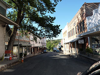
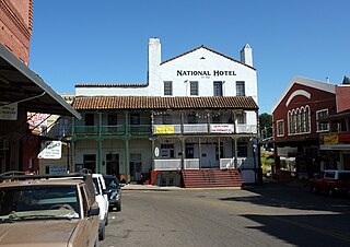
San Andreas is an unincorporated census-designated place and the county seat of Calaveras County, California. The population was 2,783 at the 2010 census, up from 2,615 at the 2000 census. Like most towns in the region, it was founded during the California Gold Rush. The town is located on State Route 49 and is registered as California Historical Landmark #252.

<span class="mw-page-title-main">Vallecito, California</span> Census-designated place in California, United States

Vallecito is a census-designated place (CDP) in Calaveras County, California, United States. The population was 442 at the 2010 census, up from 427 at the 2000 census. The town is registered as California Historical Landmark #273. Nearby is Moaning Cavern, the largest cave chamber in California, which the Miwok Indians used as a burial ground.

<span class="mw-page-title-main">Wallace, California</span> Census-designated place in California, United States

Wallace is a census-designated place (CDP) at the far west edge of Calaveras County, California, United States on State Route 12. The population was 403 at the 2010 census, up from 220 at the 2000 census.

<span class="mw-page-title-main">Tomales, California</span> Census-designated place in California, United States

Tomales is a census-designated place (CDP) on State Route 1 in Marin County, California, United States. The population was 187 at the 2020 census.

<span class="mw-page-title-main">La Porte, California</span> Census-designated place in California, United States

La Porte is a census-designated place (CDP) in Plumas County, California, United States. The population was 26 at the 2010 census, down from 43 at the 2000 census. The town was first known as Rabbit Creek.

<span class="mw-page-title-main">Chinese Camp, California</span> Census-designated place in California, United States

Chinese Camp is a census-designated place (CDP) in Tuolumne County, California, United States. The population was 126 at the 2010 census, down from 146 at the 2000 census. It lies in the grassy foothills of the Sierra Nevada near the southern end of California's Gold Country.

<span class="mw-page-title-main">Wawona, California</span> Census-designated place in California, United States

Wawona is a census-designated place in Mariposa County, California, United States. The population was 111 at the 2020 census.

<span class="mw-page-title-main">Mokelumne River</span> River in northern California

The Mokelumne River is a 95-mile (153 km)-long river in northern California in the United States. The river flows west from a rugged portion of the central Sierra Nevada into the Central Valley and ultimately the Sacramento–San Joaquin River Delta, where it empties into the San Joaquin River-Stockton Deepwater Shipping Channel. Together with its main tributary, the Cosumnes River, the Mokelumne drains 2,143 square miles (5,550 km2) in parts of five California counties. Measured to its farthest source at the head of the North Fork, the river stretches for 157 miles (253 km).

Valley Ford is an unincorporated community and census-designated place (CDP) in western Sonoma County, California, United States. It is located on State Route 1 north of San Francisco. Like all of Sonoma County, Valley Ford is included in both the San Francisco Bay Area and the Redwood Empire.

<span class="mw-page-title-main">Plains and Sierra Miwok</span> Largest group of California Indian Miwok people

The Plains and Sierra Miwok were once the largest group of California Indian Miwok people, indigenous to California. Their homeland included regions of the Sacramento Valley, San Joaquin Valley, and the Sierra Nevada.

<span class="mw-page-title-main">Woodbridge, California</span> Census-designated place in California, United States

Woodbridge is a census-designated place in San Joaquin County, California. Woodbridge sits at an elevation of 43 feet (13 m). The 2010 United States census reported Woodbridge's population was 3,984. Founded in the 1850s, the town is listed as a California Historical Landmark.

The Superior Court of California, County of Calaveras, also known as the Calaveras County Superior Court, is the branch of the California superior court with jurisdiction over Calaveras County.

References

  1. "2010 Census U.S. Gazetteer Files – Places – California". United States Census Bureau.
  2. "Mokelumne Hill". Geographic Names Information System . United States Geological Survey, United States Department of the Interior . Retrieved April 17, 2015.
  3. "Late From California". No. 519. Washington, D.C. The National Intelligencer. June 7, 1851. p. 2.
  4. Bell, Major Horace (1881). Reminiscences of a Ranger, Or Early Times in Southern California. Yarnell, Caystyle, & Mathers printers. pp. 305–306.
  5. Durham, David L. (1998). California's Geographic Names: A Gazetteer of Historic and Modern Names of the State. Clovis, Calif.: Word Dancer Press. p. 804. ISBN   1-884995-14-4.
  6. "Mokelumne Hill". Office of Historic Preservation, California State Parks. Retrieved October 6, 2012.
  7. "DREAMING CASUALLY (Investigative Blog) by J'aime Rubio".
  8. "Mokelumne Designated Historic Buildings".
  9. Climate Summary for Mokelumne Hill, California
  10. "2010 Census Interactive Population Search: CA - Mokelumne Hill CDP". U.S. Census Bureau. Archived from the original on July 15, 2014. Retrieved July 12, 2014.
  11. "Senators". State of California. Retrieved March 21, 2013.
  12. "Members Assembly". State of California. Retrieved March 21, 2013.
  13. "California's 4th Congressional District - Representatives & District Map". Civic Impulse, LLC. Retrieved March 2, 2013.