The Baetic System or Betic System is one of the main systems of mountain ranges in Spain. Located in the southern and eastern Iberian Peninsula, it is also known as the Cordilleras Béticas or Baetic Mountains. The name of the mountain system derives from the ancient Roman region of Baetica, one of the Imperial Roman provinces of ancient Hispania.

Monfragüe is a Spanish national park noted for its bird-life. It is situated in the center of a triangle formed by Plasencia, Trujillo and the city of Cáceres within the province of Cáceres. Monfragüe is also a comarca of Extremadura, western Spain.

The Sierra Morena is one of the main systems of mountain ranges in Spain. It stretches for 450 kilometres from east to west across the south of the Iberian Peninsula, forming the southern border of the Meseta Central plateau and providing the watershed between the valleys of the Guadiana to the north and the west, and the Guadalquivir to the south.

Sierra de las Nieves is a mountain range of the Penibaetic System in Málaga Province, Andalusia, Spain with its highest point being La Torrecilla.

The Sierra de Guadarrama is a mountain range forming the main eastern section of the Sistema Central, the system of mountain ranges along the centre of the Iberian Peninsula. It is located between the systems Sierra de Gredos in the province of Ávila, and Sierra de Ayllón in the province of Guadalajara.
Sierra Norte may refer to:

A dehesa is a multifunctional, agrosylvopastoral system and cultural landscape of southern and central Spain and southern Portugal; in Portugal, it is known as a montado. Its name comes from the Latin defensa (fenced), referring to land that was fenced and usually destined for pasture. Dehesas may be private or communal property. Used primarily for grazing, they produce a variety of products, including non-timber forest products such as wild game, mushrooms, honey, cork, and firewood. They are also used to raise the Spanish fighting bull and the source of jamón ibérico, the Iberian pig. The main tree component is oaks, usually holm and cork. Other oaks, including melojo and quejigo, may be used to form dehesa, the species utilized depending on geographical location and elevation. Dehesa is an anthropogenic system that provides not only a variety of foods, but also wildlife habitat for endangered species such as the Spanish imperial eagle.
The European Geoparks Network (EGN) functions as the regional organization of the Global Geoparks Network (GGN) and the UNESCO International Geosciences and Geoparks Programme (UNESCO-IGGP). Its main objective is to ensure cooperation between geoparks for the protection of geological heritage and the promotion of sustainable development of their territories in Europe. In 2020 January, the EGN had 75 institutional members from 26 European countries and there are several aspiring geopark projects, applying for a UNESCO label and therefore the permanent EGN membership.
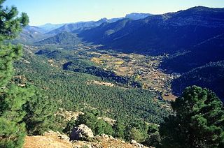
Sierras de Cazorla, Segura y Las Villas Natural Park is a natural park in the eastern and northeastern part of the province of Jaén, Spain, established in 1986. With an area of 2,099.2 square kilometres (810.5 sq mi), it is the largest protected area in Spain and the second largest in Europe. It was declared a biosphere reserve by UNESCO in 1983 and also a Special Protection Area for migratory birds in 1988.
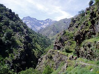
The Sierra Arana or Sierra de Arana, also known as Sierra Harana, is a mountain range in the center of the province of Granada, southern Spain. Its highest peak is the Peña de la Cruz, at 2,027 m (6,650 ft).

Moncayo is a 15 km long and about 7 km wide mountain chain giving name to the Tarazona y el Moncayo comarca, Aragon, Spain. The Moncayo's highest summit, San Miguel, is the highest point in the 500 km long Sistema Ibérico.
The Montes de Toledo is one of the main systems of mountain ranges in the Iberian Peninsula. They divide the drainage basin of the Tagus from the basin of the Guadiana. The highest peak is La Villuerca, which is 1,603 m (5,259 ft) high.

The Sierra Sur de Jaén is a mountain range that is part of the central belt of the Baetic System, Andalusia, Spain. Its name derives from its location in the southwestern part of Jaén Province. The highest summit in the range is 1,872 m high Pico Pandera; 1,722 m high Cerro de la Cruz is another notable peak.

The Sierra de Huétor is a mountain range of the Baetic System in Granada Province, Andalusia, Spain.

Sierra de Aracena is the westernmost mountain range of the Sierra Morena, Andalusia, Spain. It is located in the northern part of Huelva Province.
Sierra Norte de Sevilla may refer to various places in Spain:

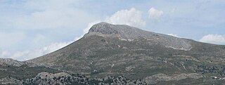
The Sierra de Almijara is a mountain range in the provinces of Granada and Málaga in southern Spain. The rocks are mainly marble, giving a white or gray color to the narrow ridges and deep ravines. The range is mostly protected by the Sierras of Tejeda, Almijara and Alhama Natural Park.

The Comarca Minera Geopark is located in the center-south of the Mexican state of Hidalgo. It extends over nine municipalities: Atotonilco el Grande, Epazoyucan, Huasca de Ocampo, Mineral del Chico, Mineral de la Reforma, Mineral del Monte, Omitlán de Juárez, Pachuca de Soto and Singuilucan. These municipalities are articulated by a network of 31 geosites, elected because they express the geological history of the territory and highlight the relationship between mining and metallurgy, and the historical spaces and cultural development of the region. In addition, they are important for science and education and, mostly, have a significant landscape value.

The Sierra de Hornachuelos Natural Park is located to the west of the Province of Córdoba and has 60,032 hectares between the municipal borders of Almodóvar del Río, Córdoba, Hornachuelos, Posadas and Villaviciosa de Córdoba. It was declared a natural park on 28 July 1989.

