Simpson's Saltings

Last updated
Simpson's Saltings
Boyton Marshes - geograph.org.uk - 1298304.jpg
Type Nature reserve
Location Hollesley, Suffolk
OS grid TM383453
Area 25 hectares
Managed by Suffolk Wildlife Trust

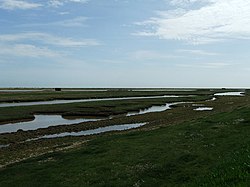
Simpson's Saltings is a 25 hectare nature reserve on the Suffolk coast east of Hollesley. It is managed by the Suffolk Wildlife Trust. [1] It is in the Suffolk Coast and Heaths Area of Outstanding Natural Beauty, [2] and part of the Alde-Ore Estuary Site of Special Scientific Interest, [3] Ramsar internationally important wetland site, [4] [5] Special Area of Conservation, [6] [7] Special Protection Area under the European Union Directive on the Conservation of Wild Birds, [8] [9] and Grade I Nature Conservation Review site, [10]

Suffolk County of England

Suffolk is an East Anglian county of historic origin in England. It has borders with Norfolk to the north, Cambridgeshire to the west and Essex to the south. The North Sea lies to the east. The county town is Ipswich; other important towns include Lowestoft, Bury St Edmunds, Newmarket and Felixstowe, one of the largest container ports in Europe.

Hollesley village in the United Kingdom

Hollesley is a village and civil parish in the Suffolk Coastal district of Suffolk in eastern England. Located on the Bawdsey peninsula five miles south-east of Woodbridge, in 2005 it had a population of 1,400 increasing to 1,581 at the 2011 Census.

Suffolk Wildlife Trust

Suffolk Wildlife Trust (SWT) describes itself as the county's "nature charity – the only organisation dedicated wholly to safeguarding Suffolk's wildlife and countryside." It is a registered charity, and its headquarters is at Brooke House in Ashbocking, near Ipswich. It was founded in 1961, and is one of 47 wildlife trusts covering the Great Britain and Northern Ireland. As of March 2017, it has 13,200 members, and it manages 3,120 hectares of land in 60 nature reserves, most of which are open to the public. It had an income of £3.9 million in the year to 31 March 2017.

The Saltings are described by the Trust as "one of the county’s most important coastal sites for its wealth of uncommon coastal and saltmarsh plants." There are also rare lichens. Habitats include intertidal mud, estuary creeks, saltmarsh, compacted sand and shingle. [1]

There is no public access but the site can be viewed from the sea wall. [1]

Related Research Articles

Orford Ness cuspate foreland shingle spit in Suffolk, England

Orford Ness is a cuspate foreland shingle spit on the Suffolk coast in Great Britain, linked to the mainland at Aldeburgh and stretching along the coast to Orford and down to North Weir Point, opposite Shingle Street. It is divided from the mainland by the River Alde, and was formed by longshore drift along the coast. The material of the spit comes from places further north, such as Dunwich. Near the middle point of its length, at the foreland point or 'Ness', lies the Orfordness Lighthouse. In the name of the lighthouse, 'Orfordness' is written as one word.

River Alde river in Suffolk, England

The River Alde is a river in Suffolk, England passing by Snape and Aldeburgh. The river is known as the River Ore as it approaches Orford and flows by a shingle spit before emptying into the North Sea.

Deben Estuary

Deben Estuary is a 981.1 hectare biological Site of Special Scientific Interest (SSSI) covering the River Deben and its banks 12 kilometres from its mouth north of Felixstowe to Woodbridge in Suffolk. It is a Ramsar internationally important wetland site and a Special Protection Area under the European Union Directive on the Conservation of Wild Birds. It is also in the Suffolk Coast and Heaths Area of Outstanding Natural Beauty. It partly overlaps two geological SSSIs, Ferry Cliff, Sutton and Ramsholt Cliff.

Havergate Island

Havergate Island is the only island in the county of Suffolk, England. It is found at the confluence of the River Ore and the Butley River near the village of Orford. It is a marshy nature reserve run by the Royal Society for the Protection of Birds (RSPB) and is known for its population of avocets and terns. It is part of the ecologically important Alde-Ore Estuary and has protected conservation status as part of a national nature reserve, SSSI, SAC, SPA, Ramsar Site and is also a part of the Suffolk Coast and Heaths AONB.

Colne Estuary biological and geological Site of Special Scientific Interest near Brightlingsea in Essex

Colne Estuary is a 2915 hectare biological and geological Site of Special Scientific Interest near Brightlingsea in Essex. It is also a Nature Conservation Review site, a National Nature Reserve, a Ramsar wetland site of international importance, a Special Protection Area, a Special Area of Conservation, and a Geological Conservation Review site. Three areas in the site are managed by the Essex Wildlife Trust, Colne Point, Fingringhoe Wick and Howlands Marsh.

Alde–Ore Estuary

Alde–Ore Estuary is a 2,534 hectare biological and geological Site of Special Scientific Interest which stretches along the Suffolk coast between Aldeburgh and Bawdsey, and also includes parts of the Alde, Ore and Butley Rivers. It is in the Suffolk Coast and Heaths Area of Outstanding Natural Beauty, and is a Grade I Nature Conservation Review site, a Special Area of Conservation, a Ramsar internationally important wetland site, and a Special Protection Area under the European Union Directive on the Conservation of Wild Birds. It includes two Geological Conservation Review sites, "Orfordness and Shingle Street" and "The Cliff, Gedgrave", and two nature reserves managed by the Suffolk Wildlife Trust, Alde Mudflats and Simpson's Saltings. The coastal part of the site is Orfordness-Havergate, a National Nature Reserve, and Orford Ness is managed by the National Trust, while Havergate Island is managed by the Royal Society for the Protection of Birds.

Trimley Marshes Suffolk Wildlife Trust nature reserve

Trimley Marshes is a 77 hectare nature reserve west of Trimley St Mary, on the outskirts of Felixstowe in Suffolk. It is managed by the Suffolk Wildlife Trust. It is in the Suffolk Coast and Heaths Area of Outstanding Natural Beauty, the Orwell Estuary Site of Special Scientific Interest, the Stour and Orwell Estuaries Ramsar site internationally important wetland site and Special Protection Area under the European Union Directive on the Conservation of Wild Birds.

Alde Mudflats Suffolk Wildlife Trust nature reserve

Alde Mudflats is a 22 hectare nature reserve west of Iken in Suffolk. It is owned by the Crown Estate and managed by the Suffolk Wildlife Trust. It is in the Suffolk Coast and Heaths Area of Outstanding Natural Beauty, and part of the Alde-Ore Estuary Site of Special Scientific Interest, Ramsar internationally important wetland site, Special Area of Conservation, Special Protection Area under the European Union Directive on the Conservation of Wild Birds, and Grade I Nature Conservation Review site,

Dingle Marshes Suffolk Wildlife Trust and RSPB nature reserve

Dingle Marshes is a 93 hectares wildlife reserve on the North Sea coast of the English county of Suffolk. The reserve is located between Dunwich and Walberswick, approximately 4 miles (6.4 km) south-west of Southwold. The marshes make up part of the Suffolk Coast National Nature Reserve along with reserves at Walberswick and Hen Reedbeds. They are owned jointly by the RSPB and Suffolk Wildlife Trust and are managed by these two organisations and Natural England. The site is in the Dunwich Heaths and Marshes Nature Conservation Review site, Grade I, the Minsmere-Walberswick Ramsar internationally important wetland site, the Minsmere to Walberswick Heaths and Marshes Special Area of Conservation, and the Minsmere-Walberswick Special Protection Area under the European Union Directive on the Conservation of Wild Birds.

Hazlewood Marshes Suffolk Wildlife Trust nature reserve

Hazlewood Marshes is a 64 hectare nature reserve west of Aldeburgh in Suffolk. It is managed by the Suffolk Wildlife Trust. It is in the Alde-Ore Estuary biological Site of Special Scientific Interest.

Holme Dunes

Holme Dunes is a 192-hectare (470-acre) nature reserve near Holme-next-the-Sea in Norfolk. It is managed by the Norfolk Wildlife Trust, and is a National Nature Reserve. It is part of the North Norfolk Coast Site of Special Scientific Interest, Geological Conservation Review site, Nature Conservation Review site, Grade I, Ramsar site, Special Areas of Conservation and Special Protection Area. It is also in the Norfolk Coast Area of Outstanding Natural Beauty.

Castle Marshes Suffolk Wildlife Trust nature reserve

Castle Marshes is a 71 hectare nature reserve west of Lowestoft in Suffolk. It is managed by the Suffolk Wildlife Trust. It is part of the Barnby Broad and Marshes Site of Special Scientific Interest the Broadland Ramsar internationally important wetland site, the Broadland Special Protection Area under the European Union Directive on the Conservation of Wild Birds, and The Broads Special Area of Conservation.

Minsmere–Walberswick Heaths and Marshes

Minsmere–Walberswick Heaths and Marshes are a Special Area of Conservation and Site of Special Scientific Interest in the English county of Suffolk. The site is located on the North Sea coast between Southwold and Sizewell, extending over an area of coastline around 7 miles (11 km) in length. The site is also designated as a Special Protection Area, part of the Minsmere–Walberswick European Marine Site and contains areas designated as Ramsar sites and Natura 2000 sites. It lies within the Suffolk Coast and Heaths Area of Outstanding Natural Beauty and is made up of a "complex mosaic" of marshes, reed beds, shingle banks and lowland heath habitats.

Stour Estuary

Stour Estuary is a 2,523 hectare biological and geological Site of Special Scientific Interest which stretches from Manningtree to Harwich in Essex and Suffolk. It is also an internationally important wetland Ramsar site, a Special Protection Area and a Nature Conservation Review site. It is part of the Suffolk Coast and Heaths Area of Outstanding Natural Beauty, and there are Geological Conservation Review sites in Wrabness, Stutton, and Harwich Part of the site is managed by the Royal Society for the Protection of Birds, and a small area is Wrabness Nature Reserve, a Local Nature Reserve managed by the Essex Wildlife Trust.

Sprats Water and Marshes, Carlton Colville

Sprat's Water and Marshes, Carlton Colville is a 57.1 hectare biological Site of Special Scientific Interest on the western outskirts of Lowestoft in Suffolk. It is part of the Broadland Ramsar internationally important wetland site, and Special Protection Area under the European Union Directive on the Conservation of Wild Birds, and part of The Broads Special Area of Conservation. The northern part of the site is Carlton Marshes, which is part of Carlton and Oulton Marshes, a nature reserve managed by the Suffolk Wildlife Trust.

Neutral Farm Pit, Butley

Neutral Farm Pit, Butley is a 1.1 hectare geological Site of Special Scientific Interest in Butley, east of Woodbridge in Suffolk. It is a Geological Conservation Review site, and is in the Suffolk Coast and Heaths Area of Outstanding Natural Beauty.

Orwell Estuary

Orwell Estuary is a 1,335.7 hectare biological Site of Special Scientific Interest which stretches along the River Orwell and its banks between Felixstowe and Ipswich in Suffolk. It is part of the Stour and Orwell Estuaries Ramsar site internationally important wetland site and Special Protection Area under the European Union Directive on the Conservation of Wild Birds. It is also in the Suffolk Coast and Heaths Area of Outstanding Natural Beauty.

Staverton Park and The Thicks, Wantisden

Staverton Park and The Thicks, Wantisden is an 80.8 hectare biological Site of Special Scientific Interest west of Butley in Suffolk. It is a Nature Conservation Review site, Grade I, and a Special Area of Conservation. It is in the Suffolk Coast and Heaths Area of Outstanding Natural Beauty.

References

  1. 1 2 3 "Simpson's Saltings". Suffolk Wildlife Trust. Retrieved 3 August 2017.
  2. "Suffolk Coast & Heaths Area of Outstanding Natural Beauty Management Plan 2013–2018" (PDF). Suffolk Coast & Heaths AONB. p. 76. Retrieved 6 August 2016.
  3. "Designated Sites View: Alde-Ore Estuary". Sites of Special Scientific Interest. Natural England. Retrieved 12 May 2017.
  4. "Information Sheet on Ramsar Wetlands: Alde-Ore Estuary" (PDF). Joint Nature Conservation Committee. Retrieved 4 May 2017.
  5. "Designated Sites View: Alde-Ore Estuary". Ramsar Site. Natural England. Retrieved 5 May 2017.
  6. "Alde, Ore and Butley Estuaries". Special Areas of Conservation. Joint Nature Conservation Committee. Retrieved 4 May 2017.
  7. "Designated Sites View: Alde, Ore and Butley Estuaries". Special Area of Conservation. Natural England. Retrieved 5 May 2017.
  8. "Alde–Ore Estuary". Special Protection Areas. Joint Nature Conservation Committee. Retrieved 3 May 2017.
  9. "Designated Sites View: Alde-Ore Estuary". Special Protection Area. Natural England. Retrieved 5 May 2017.
  10. Ratcliffe, Derek, ed. (1977). A Nature Conservation Review. 2. Cambridge, UK: Cambridge University Press. p. 9. ISBN   0-521-21403-3.

Coordinates: 52°03′18″N1°28′26″E / 52.055°N 1.474°E / 52.055; 1.474

Geographic coordinate system Coordinate system

A geographic coordinate system is a coordinate system that enables every location on Earth to be specified by a set of numbers, letters or symbols. The coordinates are often chosen such that one of the numbers represents a vertical position and two or three of the numbers represent a horizontal position; alternatively, a geographic position may be expressed in a combined three-dimensional Cartesian vector. A common choice of coordinates is latitude, longitude and elevation. To specify a location on a plane requires a map projection.