Levington Lagoon

Last updated
Levington Lagoon
Levington Lagoon 4.jpg
Type Nature reserve
Location Levington, Suffolk
OS grid TM238389
Area 5 hectares
Managed by Suffolk Wildlife Trust

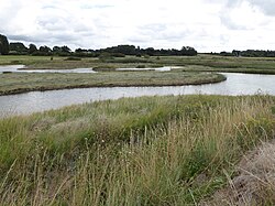
Levington Lagoon is a 5 hectare nature reserve south-east of Levington in Suffolk. It is owned by Suffolk Yacht Harbour Ltd and managed by the Suffolk Wildlife Trust. [1]

Levington is a small village in the Suffolk Coastal district, in the county of Suffolk, England. The population of the parish including Stratton Hall at the 2011 Census was 259.

Suffolk County of England

Suffolk is an East Anglian county of historic origin in England. It has borders with Norfolk to the north, Cambridgeshire to the west and Essex to the south. The North Sea lies to the east. The county town is Ipswich; other important towns include Lowestoft, Bury St Edmunds, Newmarket and Felixstowe, one of the largest container ports in Europe.

Suffolk Wildlife Trust

Suffolk Wildlife Trust (SWT) describes itself as the county's "nature charity – the only organisation dedicated wholly to safeguarding Suffolk's wildlife and countryside." It is a registered charity, and its headquarters is at Brooke House in Ashbocking, near Ipswich. It was founded in 1961, and is one of 47 wildlife trusts covering the Great Britain and Northern Ireland. As of March 2017, it has 13,200 members, and it manages 3,120 hectares of land in 60 nature reserves, most of which are open to the public. It had an income of £3.9 million in the year to 31 March 2017.

This area of open water and saltmarsh on the bank of the River Orwell was formed when the sea wall was breached during the North Sea flood of 1953. The birds are diverse, including greenshanks, dunlins, spotted redshanks, pipits and dunlins. There are plants such as sea lavender. [1]

River Orwell river in Suffolk, England

The River Orwell flows through the county of Suffolk in England. Its source river, above the tidal limit at Stoke Bridge, is known as the River Gipping. It broadens into an estuary at Ipswich where the Ipswich dock has operated since the 7th century and then flows into the North Sea at Felixstowe the UK's largest container port after joining with the River Stour at Shotley forming Harwich harbour.

North Sea flood of 1953 Late January-early February 1953 North sea flood storm

The 1953 North Sea flood was a major flood caused by a heavy storm that occurred on the night of Saturday, 31 January 1953 and morning of Sunday, 1 February 1953. The floods struck the Netherlands, Belgium, England and Scotland.

Dunlin species of bird

The dunlin is a small wader, sometimes separated with the other "stints" in Erolia. The English name is a dialect form of "dunling", first recorded in 1531–2. It derives from dun, "dull brown", with the suffix -ling, meaning a person or thing with the given quality. The genus name is from Ancient Greek kalidris or skalidris, a term used by Aristotle for some grey-coloured waterside birds. The specific alpina is from Latin and means "of high mountains", in this case referring to the Alps.

There is no public access to the site but it can be viewed from the Stour and Orwell Walk.

Related Research Articles

Nacton village in the United Kingdom

Nacton is a civil parish in the Suffolk Coastal region of Suffolk, England, taking its name from the village within it. The parish is bounded by the neighbouring parishes of Levington to the east and Bucklesham in the north. It is located between the towns of Ipswich and Felixstowe.

Alde–Ore Estuary

Alde–Ore Estuary is a 2,534 hectare biological and geological Site of Special Scientific Interest which stretches along the Suffolk coast between Aldeburgh and Bawdsey, and also includes parts of the Alde, Ore and Butley Rivers. It is in the Suffolk Coast and Heaths Area of Outstanding Natural Beauty, and is a Grade I Nature Conservation Review site, a Special Area of Conservation, a Ramsar internationally important wetland site, and a Special Protection Area under the European Union Directive on the Conservation of Wild Birds. It includes two Geological Conservation Review sites, "Orfordness and Shingle Street" and "The Cliff, Gedgrave", and two nature reserves managed by the Suffolk Wildlife Trust, Alde Mudflats and Simpson's Saltings. The coastal part of the site is Orfordness-Havergate, a National Nature Reserve, and Orford Ness is managed by the National Trust, while Havergate Island is managed by the Royal Society for the Protection of Birds.

Pennyhole Bay is a stretch of water situated to the south of the ports of Harwich in Essex and Felixstowe in Suffolk, England where the rivers Stour and Orwell flow into the sea and just east of Walton-on-the-Naze in Essex. Much of the bay is clogged up with Shoals. The Pennyhole Bay Race is an annual gaff rig sailing race which traditionally starts from either Suffolk Yacht Harbour in Levington or from Stone Point.

Thorington village in the United Kingdom

Thorington is a village and a civil parish in the hundred of Blything, in the Suffolk Coastal District of the English county of Suffolk. It is located around 3 miles (4.8 km) south-east of the town of Halesworth, immediately south of the village of Wenhaston. The A12 main road runs through the parish to the east of the village.

Framlingham Mere Suffolk Wildlife Trust nature reserve

Framlingham Mere is a 13.8 hectare nature reserve in Framlingham in Suffolk. It is managed by the Suffolk Wildlife Trust.

Trimley Marshes Suffolk Wildlife Trust nature reserve

Trimley Marshes is a 77 hectare nature reserve west of Trimley St Mary, on the outskirts of Felixstowe in Suffolk. It is managed by the Suffolk Wildlife Trust. It is in the Suffolk Coast and Heaths Area of Outstanding Natural Beauty, the Orwell Estuary Site of Special Scientific Interest, the Stour and Orwell Estuaries Ramsar site internationally important wetland site and Special Protection Area under the European Union Directive on the Conservation of Wild Birds.

Darsham Marshes Suffolk Wildlife Trust nature reserve

Darsham Marshes is a 20 hectare nature reserve south of Darsham in Suffolk, England. It is owned and managed by the Suffolk Wildlife Trust.

Brooke House Ipplepen, Teignbridge, Devon, TQ12

Brooke House in Ashbocking, north of Ipswich in Suffolk is the headquarters of the Suffolk Wildlife Trust.

Sizewell Belts Suffolk Wildlife Trust nature reserve

Sizewell Marshes is a 105.4 hectare biological Site of Special Scientific Interest adjacent to Sizewell in Suffolk. It is in the Suffolk Coast and Heaths Area of Outstanding Natural Beauty, and is part of a 144 hectare nature reserve managed by the Suffolk Wildlife Trust as Sizewell Belts.

Hen Reedbeds Suffolk Wildlife Trust nature reserve

Hen Reedbeds is a 55 hectare nature reserve near the North Sea coast of the English county of Suffolk. The reserve is located in the Blyth valley between Reydon and Blythburgh, approximately 2.5 miles (4.0 km) west of Southwold. The marshes make up part of the Suffolk Coast National Nature Reserve along with reserves at Walberswick and Dingle Marshes.

Hazlewood Marshes Suffolk Wildlife Trust nature reserve

Hazlewood Marshes is a 64 hectare nature reserve west of Aldeburgh in Suffolk. It is managed by the Suffolk Wildlife Trust. It is in the Alde-Ore Estuary biological Site of Special Scientific Interest.

Reydon Wood Suffolk Wildlife Trust nature reserve

Reydon Wood is a 16 hectare nature reserve west of Wangford in Suffolk. It is managed by the Suffolk Wildlife Trust.

Foxburrow Farm Suffolk Wildlife Trust nature reserve

Foxburrow Farm is a 67 hectare nature reserve north of Melton in Suffolk. It is managed by the Suffolk Wildlife Trust.

Suffolk Coast National Nature Reserve

Suffolk Coast National Nature Reserve is a wildlife reserve on the North Sea coast of the English county of Suffolk. It is located around the village of Walberswick to the south of the town of Southwold. The reserve was designated in 2003, combining the existing Walberswick National Nature Reserve with reserves at Dingle Marshes and Hen Reedbeds to create a 1,340 hectares reserve.

Stour Estuary

Stour Estuary is a 2,523 hectare biological and geological Site of Special Scientific Interest which stretches from Manningtree to Harwich in Essex and Suffolk. It is also an internationally important wetland Ramsar site, a Special Protection Area and a Nature Conservation Review site. It is part of the Suffolk Coast and Heaths Area of Outstanding Natural Beauty, and there are Geological Conservation Review sites in Wrabness, Stutton, and Harwich Part of the site is managed by the Royal Society for the Protection of Birds, and a small area is Wrabness Nature Reserve, a Local Nature Reserve managed by the Essex Wildlife Trust.

Nacton Meadows

Nacton Meadows is a 4.5 hectare biological Site of Special Scientific Interest north-west of Levington in Suffolk. It is in the Suffolk Coast and Heaths Area of Outstanding Natural Beauty

Papermill Reedbed Suffolk Wildlife Trust nature reserve

Papermill Reedbed is a 6 hectare nature reserve in Bramford in Suffolk. It is owned by Blakenham Farms and managed by the Suffolk Wildlife Trust.

References

  1. 1 2 "Levington Lagoon". Suffolk Wildlife Trust. Retrieved 14 August 2017.

Coordinates: 52°00′11″N1°15′32″E / 52.003°N 1.259°E / 52.003; 1.259

Geographic coordinate system Coordinate system

A geographic coordinate system is a coordinate system that enables every location on Earth to be specified by a set of numbers, letters or symbols. The coordinates are often chosen such that one of the numbers represents a vertical position and two or three of the numbers represent a horizontal position; alternatively, a geographic position may be expressed in a combined three-dimensional Cartesian vector. A common choice of coordinates is latitude, longitude and elevation. To specify a location on a plane requires a map projection.