
Suffolk Wildlife Trust (SWT) describes itself as the county's "nature charity – the only organisation dedicated wholly to safeguarding Suffolk's wildlife and countryside." It is a registered charity, and its headquarters is at Brooke House in Ashbocking, near Ipswich. It was founded in 1961, and is one of 46 wildlife trusts covering the Great Britain and Northern Ireland. As of March 2017, it has 13,200 members, and it manages 3,120 hectares of land in 60 nature reserves, most of which are open to the public. It had an income of £3.9 million in the year to 31 March 2017.

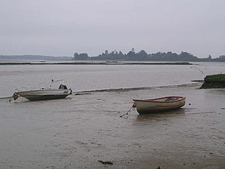
Deben Estuary is a 981.1-hectare (2,424-acre) biological Site of Special Scientific Interest (SSSI) covering the River Deben and its banks 12 kilometres from its mouth north of Felixstowe to Woodbridge in Suffolk. It is a Ramsar internationally important wetland site and a Special Protection Area under the European Union Directive on the Conservation of Wild Birds. It is also in the Suffolk Coast and Heaths Area of Outstanding Natural Beauty. It partly overlaps two geological SSSIs, Ferry Cliff, Sutton and Ramsholt Cliff.

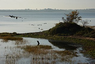
Alde–Ore Estuary is a 2,534 hectare biological and geological Site of Special Scientific Interest which stretches along the Suffolk coast between Aldeburgh and Bawdsey, and also includes parts of the Alde, Ore and Butley Rivers. It is in the Suffolk Coast and Heaths Area of Outstanding Natural Beauty, and is a Grade I Nature Conservation Review site, a Special Area of Conservation, a Ramsar internationally important wetland site, and a Special Protection Area under the European Union Directive on the Conservation of Wild Birds. It includes two Geological Conservation Review sites, "Orfordness and Shingle Street" and "The Cliff, Gedgrave", and two nature reserves managed by the Suffolk Wildlife Trust, Alde Mudflats and Simpson's Saltings. The coastal part of the site is Orfordness-Havergate, a National Nature Reserve, and Orford Ness is managed by the National Trust, while Havergate Island is managed by the Royal Society for the Protection of Birds.

Wangford Warren and Carr is a 67.8-hectare (168-acre) biological Site of Special Scientific Interest between Brandon and Lakenheath in Suffolk. It is a Nature Conservation Review site, Grade I, and part of the Breckland Special Area of Conservation, and Special Protection Area An area of 15 hectares is managed as a nature reserve by the Suffolk Wildlife Trust

Trimley Marshes is a 77 hectare nature reserve west of Trimley St Mary, on the outskirts of Felixstowe in Suffolk. It is managed by the Suffolk Wildlife Trust. It is in the Suffolk Coast and Heaths Area of Outstanding Natural Beauty, the Orwell Estuary Site of Special Scientific Interest, the Stour and Orwell Estuaries Ramsar site internationally important wetland site and Special Protection Area under the European Union Directive on the Conservation of Wild Birds.

Blaxhall Common is a nature reserve in the parish of Blaxhall in the East Suffolk District of Suffolk. The reserve is owned by Blaxhall Parish Council and managed by Suffolk Wildlife Trust. It is designated a 45.9-hectare (113-acre) biological Site of Special Scientific Interest as Blaxhall Heath. It is part of the Sandlings Special Protection Area under the European Union Directive on the Conservation of Wild Birds, and of the Suffolk Coast and Heaths Area of Outstanding Natural Beauty. A Bronze Age bowl barrow is a Scheduled Monument.
Alde Mudflats is a 22 hectare nature reserve west of Iken in Suffolk. It is owned by the Crown Estate and managed by the Suffolk Wildlife Trust. It is in the Suffolk Coast and Heaths Area of Outstanding Natural Beauty, and part of the Alde-Ore Estuary Site of Special Scientific Interest, Ramsar internationally important wetland site, Special Area of Conservation, Special Protection Area under the European Union Directive on the Conservation of Wild Birds, and Grade I Nature Conservation Review site,

Sizewell Marshes form a 260-acre biological Site of Special Scientific Interest adjacent to Sizewell in Suffolk. It is in the Suffolk Coast and Heaths Area of Outstanding Natural Beauty, and is part of a 356-acre (144-ha) nature reserve managed by the Suffolk Wildlife Trust as Sizewell Belts.

Simpson's Saltings is a 25 hectare nature reserve on the Suffolk coast east of Hollesley. It is managed by the Suffolk Wildlife Trust. It is in the Suffolk Coast and Heaths Area of Outstanding Natural Beauty, and part of the Alde-Ore Estuary Site of Special Scientific Interest, Ramsar internationally important wetland site, Special Area of Conservation, Special Protection Area under the European Union Directive on the Conservation of Wild Birds, and Grade I Nature Conservation Review site,
Stour Estuary is a 2,523 hectare biological and geological Site of Special Scientific Interest which stretches from Manningtree to Harwich in Essex and Suffolk. It is also an internationally important wetland Ramsar site, a Special Protection Area and a Nature Conservation Review site. It is part of the Suffolk Coast and Heaths Area of Outstanding Natural Beauty, and there are Geological Conservation Review sites in Wrabness, Stutton, and Harwich Part of the site is managed by the Royal Society for the Protection of Birds, and a small area is Wrabness Nature Reserve, a Local Nature Reserve managed by the Essex Wildlife Trust.

Potton Hall Fields, Westleton is a 16.7-hectare (41-acre) biological Site of Special Scientific Interest ( west of Dunwich in Suffolk. It is in the Suffolk Coast and Heaths Area of Outstanding Natural Beauty.

Cavenham–Icklingham Heaths is a 419 hectare biological Site of Special Scientific Interest west of Icklingham in Suffolk. It is a Nature Conservation Review site, Grade I, and part of Breckland Special Area of Conservation and Breckland Special Protection Area under the European Union Directive on the Conservation of Wild Birds. Cavenham Heath is a 203.1 hectare National Nature Reserve.

Leiston - Aldeburgh is a 534.8-hectare (1,322-acre) biological Site of Special Scientific Interest which stretches from Aldeburgh to Leiston in Suffolk. Part of it is The Haven, Aldeburgh Local Nature Reserve, and another area is the North Warren RSPB nature reserve. There is also a prehistoric bowl barrow on Aldringham Common, which is a Scheduled Monument. The site is in the Sandlings Special Protection Area under the European Union Directive on the Conservation of Wild Birds, and the Suffolk Coast and Heaths Area of Outstanding Natural Beauty.
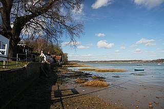
Orwell Estuary is a 1,335.7 hectare biological Site of Special Scientific Interest which stretches along the River Orwell and its banks between Felixstowe and Ipswich in Suffolk. It is part of the Stour and Orwell Estuaries Ramsar site internationally important wetland site and Special Protection Area under the European Union Directive on the Conservation of Wild Birds. It is also in the Suffolk Coast and Heaths Area of Outstanding Natural Beauty.
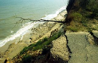
Pakefield to Easton Bavents is a 735.4-hectare (1,817-acre) biological and geological Site of Special Scientific Interest which stretches along the Suffolk coast between Lowestoft and Southwold. It includes three Geological Conservation Review sites, and part of the Benacre National Nature Reserve. An area of 326.7 hectares is the Benacre to Easton Bavents Lagoons Special Area of Conservation, and 470.6 hectares is the Benacre to Easton Bavents Special Protection Area under the European Union Directive on the Conservation of Wild Birds. The site is also partly in the Suffolk Coast and Heaths Area of Outstanding Natural Beauty.

Sandlings Forest is a 2,483.8 hectare biological Site of Special Scientific Interest in two large blocks, Rendlesham Forest and Tunstall Forest, and two small ones, between Woodbridge and Aldeburgh in Suffolk. It is partly in the Sandlings Special Protection Area under the European Union Directive on the Conservation of Wild Birds. It is in the Suffolk Coast and Heaths Area of Outstanding Natural Beauty.

Snape Warren is a 48 hectare biological Site of Special Scientific Interest east of Snape in Suffolk. It is part of the Sandlings Special Protection Area under the European Union Directive on the Conservation of Wild Birds, and in the Suffolk Coast and Heaths Area of Outstanding Natural Beauty.

Tunstall Common is a 36.6 hectare biological Site of Special Scientific Interest east of Tunstall in Suffolk. It is part of the Sandlings Special Protection Area under the European Union Directive on the Conservation of Wild Birds, and the Suffolk Coast and Heaths Area of Outstanding Natural Beauty.

Ferry Cliff, Sutton is a 2.8-hectare (6.9-acre) geological Site of Special Scientific Interest Suffolk. It is a Geological Conservation Review site, and it is in the Suffolk Coast and Heaths Area of Outstanding Natural Beauty.
