
St. Mary Parish is a parish located in the U.S. state of Louisiana. As of the 2020 census, the population was 49,406. The parish seat is Franklin. The parish was created in 1811.
Red Chute is a census-designated place (CDP) in Bossier Parish, Louisiana, United States. The population was 6,261 at the 2010 census. It is part of the Shreveport–Bossier City Metropolitan Statistical Area.
Carlyss is a census-designated place (CDP) in Calcasieu Parish, Louisiana, United States. The population was 5,101 in 2020. It is part of the Lake Charles metropolitan statistical area.
Inniswold is an unincorporated area and census-designated place (CDP) in East Baton Rouge Parish, Louisiana, United States. The population was 6,180 at the 2010 census, up from 4,944 in 2000. In 2020, its population was 5,987. It is part of the Baton Rouge metropolitan statistical area.

Merrydale is an unincorporated area and census-designated place (CDP) in East Baton Rouge Parish, Louisiana, United States. The population was 9,772 at the 2010 census, down from 10,427 in 2000. It is part of the Baton Rouge Metropolitan Statistical Area.
Lydia is an unincorporated community and census-designated place (CDP) in Iberia Parish, Louisiana, United States. The population was 952 at the 2010 census, down from 1,079 at the 2000 census. It is part of the New Iberia Micropolitan Statistical Area.
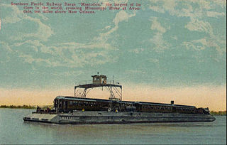
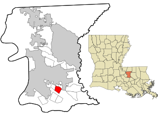
Avondale is a census-designated place (CDP) in Jefferson Parish, Louisiana, United States, on the west bank of the Mississippi River. The population was 4,582 in 2020. It is part of the New Orleans–Metairie–Kenner metropolitan statistical area.

Raceland is an unincorporated community and census-designated place (CDP) on Bayou Lafourche in Lafourche Parish, Louisiana, United States. The population was 9,768 in 2020. It is part of the Houma–Bayou Cane–Thibodaux metropolitan statistical area.
Amelia is a census-designated place (CDP) in St. Mary Parish, Louisiana, United States. The population was 2,459 at the 2010 census. It is part of the Morgan City Micropolitan Statistical Area.

Littleton Common is a census-designated place (CDP) in the town of Littleton in Middlesex County, Massachusetts, United States. The population was 3,065 at the 2020 census, up from 2,789 in 2010.

Plattsburgh West is a census-designated place (CDP) and region of the town of Plattsburgh in Clinton County, New York, United States. The population was 1,364 at the 2010 census. The CDP lies to the west of the city of Plattsburgh.
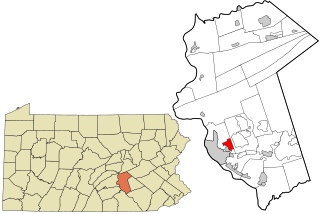
Progress is an unincorporated community and census-designated place (CDP) mainly in Susquehanna Township but also in Lower Paxton Township, Dauphin County, Pennsylvania, United States. The population was 9,765 at the 2010 census. It is part of the Harrisburg–Carlisle Metropolitan Statistical Area.

Northwest Harborcreek is a census-designated place (CDP) in Erie County, Pennsylvania, United States. The population was 8,949 at the 2010 census. It includes the unincorporated communities of Fairfield and Brookside and is part of the Erie Metropolitan Statistical Area.
Parker is a census-designated place (CDP) in Greenville County, South Carolina, United States. The population was 11,431 at the 2010 census, up from 10,760 in 2000. It is part of the Greenville–Mauldin–Easley Metropolitan Statistical Area.
Lynnwood-Pricedale is a census-designated place (CDP) in Fayette and Westmoreland counties in the commonwealth of Pennsylvania, United States. The population was 2,031 at the 2010 census, down from 2,168 at the 2000 census. The community of Lynwood is located in Fayette County's Washington Township, while Pricedale is part of Westmoreland County's Rostraver Township.

Epping is a census-designated place (CDP) and the main village in the town of Epping, Rockingham County, New Hampshire, United States. The population of the CDP was 2,693 at the 2020 census, out of 7,125 in the entire town.

Brownsville is an unincorporated community and census-designated place (CDP) in northeastern Bowling Green Township, Licking County, Ohio, United States. As of the 2010 census, it had a population of 220. It lies at the intersection of U.S. Route 40 with State Route 668.
Glencoe is a census-designated place (CDP) in St. Mary Parish, Louisiana, United States. The population was 126 at the 2010 census. It is part of the Morgan City Micropolitan Statistical Area.
Sorrel is a census-designated place (CDP) in St. Mary Parish, Louisiana, United States. The population was 766 at the 2010 census. It is part of the Morgan City Micropolitan Statistical Area.

Oakland is a census-designated place (CDP) comprising the main population center in the town of Oakland in Kennebec County, Maine, United States. The population was 2,602 at the 2010 census, out of 6,240 in the entire town of Oakland.

