
The Oregon Trail was a 2,170-mile (3,490 km) east–west, large-wheeled wagon route and emigrant trail in the United States that connected the Missouri River to valleys in Oregon Territory. The eastern part of the Oregon Trail crossed what is now the states of Kansas, Nebraska, and Wyoming. The western half crossed the current states of Idaho and Oregon.

Interstate 5 (I-5) is the main north–south Interstate Highway on the West Coast of the United States, running largely parallel to the Pacific Coast of the contiguous U.S. from Mexico to Canada. It travels through the states of California, Oregon, and Washington, serving several large cities on the West Coast, including San Diego, Los Angeles, Sacramento, Portland, and Seattle. It is the only continuous Interstate highway to touch both the Mexican and Canadian borders. Upon crossing the Mexican border at its southern terminus, the highway continues to Tijuana, Baja California, as Mexican Federal Highway 1 (Fed. 1). Upon crossing the Canadian border at its northern terminus, it continues to Vancouver as British Columbia Highway 99 (BC 99).

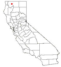
Siskiyou County is a county located in the northwestern part of the U.S. state of California. As of the 2020 census, the population was 44,076. Its county seat is Yreka and its highest point is Mount Shasta. It falls within the Cascadia bioregion.
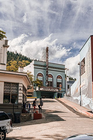
Dunsmuir is a city in Siskiyou County, northern California. It is on the upper Sacramento River. Its population is 1,707 as of the 2020 census, up from 1,650 from the 2010 census.
The Shasta Cascade region of California is located in the northeastern and north-central sections of the state bordering Oregon and Nevada, including far northern parts of the Central Valley and the Sierra Nevada mountain range.
Pacific Highway is the name of several north–south highways in the Pacific Coast region of the Western United States, either by legislation officially designating it as such or by common usage.

U.S. Route 99 (US 99) was a main north–south United States Numbered Highway on the West Coast of the United States until 1964, running from Calexico, California, on the Mexican border to Blaine, Washington, on the Canadian border. It was assigned in 1926 and existed until it was replaced for the most part by Interstate 5. Known also as the "Golden State Highway" and "The Main Street of California", US 99 was important throughout much of the 1930s as a route for Dust Bowl immigrant farm workers to traverse the state. Large portions are now California State Route 99 (SR 99), Oregon's Routes 99, 99W, and 99E, and Washington's SR 99. The highway in Washington connected to British Columbia Highway 99, whose number was derived from that of US 99, at the Canada–US border.

The Siskiyou Mountains are a coastal subrange of the Klamath Mountains, and located in northwestern California and southwestern Oregon in the United States. They extend in an arc for approximately 100 miles (160 km) from east of Crescent City, California, northeast along the north side of the Klamath River into Josephine and Jackson counties in Oregon. The mountain range forms a barrier between the watersheds of the Klamath River to the south and the Rogue River to the north. Accordingly, much of the range is within the Rogue River – Siskiyou and Klamath national forests, and the Pacific Crest Trail follows a portion of the crest of the Siskiyous.

The South Umpqua River is a tributary of the Umpqua River, approximately 115 miles (185 km) long, in southwestern Oregon in the United States. It drains part of the Cascade Range east of Roseburg. The river passes through a remote canyon in its upper reaches then emerges in the populated South Umpqua Valley east of Canyonville.

Peter Skene Ogden was a British-Canadian fur trader and an early explorer of what is now British Columbia and the Western United States. During his many expeditions, he explored parts of Oregon, Washington, Nevada, California, Utah, Idaho, and Wyoming. Despite early confrontations with the Hudson's Bay Company (HBC) while working for the North West Company, he later became a senior official in the operations of the HBC's Columbia Department, serving as manager of Fort Simpson and similar posts.

Upper Soda Springs is on the banks of the Sacramento River in Dunsmuir, California, USA. It consists of approximately 15 acres of level ground on both sides of the River, the surrounding hillsides, and continues north along the eastern bank of the Sacramento River to the Dunsmuir City Park. The State of California and the City of Dunsmuir oversee a public park on this historic site. The Upper Soda Springs site contains a riparian ecosystem and includes its namesake mineral water springs. In large part because of its location on the Siskiyou Trail, the site mirrors the history of the state and of the American West.
Ross Quartz McCloud was a California pioneer and early settler in Northern California. While he is regarded by some as a namesake of the town of McCloud, California, and the nearby McCloud River, please see historical note below.
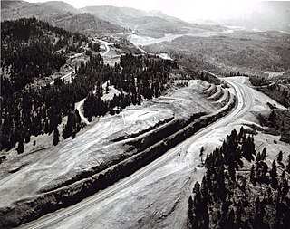
Siskiyou Pass is a historic mountain pass in the Siskiyou Mountains of Jackson County in the U.S. state of Oregon. It is the most used pass in Oregon. The Hudson's Bay Company (HBC) made the Siskiyou Trail over the pass before pioneers traversed it with their wagons, while still later it evolved into a stage road, a railroad line, and a highway route. The name Siskiyou is believed to be derived from Cree, meaning "bob-tailed horse". Siskiyou Pass is west of the summit of Interstate 5, which is known as Siskiyou Summit.
Scott Valley is a large, scenic rural area of western Siskiyou County, California, known for its vistas of the Marble Mountains, cattle and dairy ranches, and its historic background as a gold mining area, dating back to the days of the California Gold Rush. The towns of Fort Jones, Etna, Greenview and Callahan are found within Scott Valley, as well as many other small villages.

Siskiyou Summit is a summit on Interstate 5 (I-5) in the U.S. state of Oregon. It is distinct from Siskiyou Pass, which is a nearby, historical mountain pass. Siskiyou Summit is situated in the Siskiyou Mountains, approximately 4 miles (6.4 km) north of the California border. At 4,310 feet (1,310 m), it is the highest point on Interstate 5. When the highway was rebuilt on its current alignment, road cutting lowered the elevation of the summit by 49 feet (15 m).

Jesse Applegate was an American pioneer who led a large group of settlers along the Oregon Trail to the Oregon Country. He was an influential member of the early government of Oregon, and helped establish the Applegate Trail as an alternative route to the Oregon Trail.
Ewing Young was an American fur trapper and trader from Tennessee who traveled in what was then the northern Mexico frontier territories of Santa Fe de Nuevo México and Alta California before settling in the Oregon Country. Young traded along the Santa Fe Trail, followed parts of the Old Spanish Trail west, and established new trails. He later moved north to the Willamette Valley. As a prominent and wealthy citizen in Oregon, his death was the impetus for the assemblies that several years later established the Provisional Government of Oregon.
Alexander Roderick McLeod was a fur trader and explorer in British North America who began his career with the North West Company in 1802.
Thomas McKay was an Anglo-Métis Canadian fur trader who worked mainly in the Pacific Northwest for the Pacific Fur Company (PFC), the North West Company (NWC), and the Hudson's Bay Company (HBC). He was a fur brigade leader and explorer of the Columbia District and later became a U.S. citizen and an early settler of Oregon.

The Klamathon Fire was a wildfire in Siskiyou County south of Hornbrook, California in the United States. The fire was reported on July 5, 2018 and was contained on July 21, after burning 38,008 acres (154 km2). The fire threatened private timber lands along the California-Oregon border; public lands in the Klamath National Forest; Rogue River-Siskiyou National Forest; Jackson County, Oregon; communities of Hornbrook and Hilt, California; and Colestin, Oregon. It destroyed 82 structures, damaged 12 structures, injured three firefighters, and killed one civilian.
