The Potomac River drains the Mid-Atlantic United States, flowing from the Potomac Highlands into Chesapeake Bay. It is 405 miles (652 km) long, with a drainage area of 14,700 square miles (38,000 km2), and is the fourth-largest river along the East Coast of the United States and the 21st-largest in the United States. Over 5 million people live within its watershed. There is a hydroelectric plant on the river constructed in 2014 by Dominion.

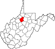
Doddridge County is a county in the U.S. state of West Virginia. Its county seat is West Union.

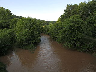
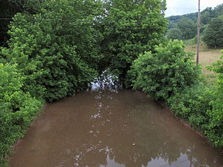
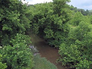
Middle Island Creek is a river, 77 miles (124 km) long, in northwestern West Virginia in the United States. It is a tributary of the Ohio River, draining an area of 565 square miles (1,463 km2) on the unglaciated Allegheny Plateau. It was named by late 18th century pioneering travelers on the Ohio River, who noted the location of the Creek's mouth opposite Middle Island in the larger river.
Sleepy Creek is a 44.0-mile-long (70.8 km) tributary of the Potomac River in the United States, belonging to the Chesapeake Bay's watershed. The stream rises in Frederick County, Virginia, and flows through Morgan County, West Virginia before joining the Potomac near the community of Sleepy Creek.
The Jug — formerly known as the Jug Handle — is a jug-shaped island formed by a horseshoe bend on Middle Island Creek near Middlebourne in Tyler County, West Virginia, USA. It is maintained by the state of West Virginia as The Jug Wildlife Management Area.
Sugar Valley is an unincorporated community in Pleasants County, West Virginia, United States. The community is located at the confluence of Sugar Creek and Middle Island Creek.
Union Mills is an unincorporated community in Pleasants County, West Virginia, United States. The community is located along McKim Creek at its confluence with Middle Island Creek.
Booher is an unincorporated community in Tyler County, West Virginia, United States, along Indian Creek. Its post office is closed.

Buckeye Creek is a tributary of Middle Island Creek, 12.7 miles (20.4 km) long, in north-central West Virginia in the United States. Via Middle Island Creek and the Ohio River, it is part of the watershed of the Mississippi River, draining an area of 39.1 square miles (101 km2) in a rural region on the unglaciated portion of the Allegheny Plateau.

The Meathouse Fork is a tributary of Middle Island Creek, 19.7 miles (31.7 km) long, in north-central West Virginia in the United States. Via Middle Island Creek and the Ohio River, it is part of the watershed of the Mississippi River, draining an area of 64.6 square miles (167 km2) in a rural region on the unglaciated portion of the Allegheny Plateau.
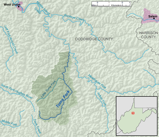
Toms Fork is a tributary of the Meathouse Fork, 9.3 miles (15.0 km) long, in north-central West Virginia in the United States. Via the Meathouse Fork, Middle Island Creek, and the Ohio River, it is part of the watershed of the Mississippi River, draining an area of 15.5 square miles (40 km2) in a rural region on the unglaciated portion of the Allegheny Plateau.

Arnold Creek is a tributary of Middle Island Creek, 10.9 miles (17.5 km) long, in West Virginia in the United States. Via Middle Island Creek and the Ohio River, it is part of the watershed of the Mississippi River, draining an area of 34.7 square miles (90 km2) in a rural region on the unglaciated portion of the Allegheny Plateau.
McElroy Creek is a tributary of Middle Island Creek, 22.1 miles (35.6 km) long, in northern West Virginia in the United States. Via Middle Island Creek and the Ohio River, it is part of the watershed of the Mississippi River, draining an area of 106.2 square miles (275 km2) in a rural region on the unglaciated portion of the Allegheny Plateau.

Flint Run is a tributary of McElroy Creek, 7.5 miles (12.1 km) long, in northern West Virginia in the United States. Via McElroy Creek, Middle Island Creek, and the Ohio River, it is part of the watershed of the Mississippi River, draining an area of 25.6 square miles (66 km2) in a rural region on the unglaciated portion of the Allegheny Plateau.

Indian Creek is a tributary of Middle Island Creek, 14.8 miles (23.8 km) long, in northern West Virginia in the United States. Via Middle Island Creek and the Ohio River, it is part of the watershed of the Mississippi River, draining an area of 32.3 square miles (84 km2) in a rural region on the unglaciated portion of the Allegheny Plateau.

Point Pleasant Creek is a tributary of Middle Island Creek, 10.4 miles (16.7 km) long, in northwestern West Virginia in the United States. Via Middle Island Creek and the Ohio River, it is part of the watershed of the Mississippi River, draining an area of 60.5 square miles (157 km2) in a rural region on the unglaciated portion of the Allegheny Plateau.
The Elk Fork is a tributary of Point Pleasant Creek, 14.8 miles (23.8 km) long, in northwestern West Virginia in the United States. Via Point Pleasant Creek, Middle Island Creek, and the Ohio River, it is part of the watershed of the Mississippi River, draining an area of 21.1 square miles (55 km2) in a rural region on the unglaciated portion of the Allegheny Plateau.
Sancho Creek is a tributary of Middle Island Creek, 9.6 miles (15.4 km) long, in northwestern West Virginia in the United States. Via Middle Island Creek and the Ohio River, it is part of the watershed of the Mississippi River, draining an area of 22.2 square miles (57 km2) in a rural region on the unglaciated portion of the Allegheny Plateau.
Sugar Creek is a tributary of Middle Island Creek, 15 miles (24 km) long, in northwestern West Virginia in the United States. Via Middle Island Creek and the Ohio River, it is part of the watershed of the Mississippi River, draining an area of 22.1 square miles (57 km2) in a rural region on the unglaciated portion of the Allegheny Plateau.

McKim Creek is a tributary of Middle Island Creek, 20.4 miles (32.8 km) long, in northwestern West Virginia in the United States. Via Middle Island Creek and the Ohio River, it is part of the watershed of the Mississippi River, draining an area of 37.3 square miles (97 km2) in a rural region on the unglaciated portion of the Allegheny Plateau.