
The Snake River is a major river of the greater Pacific Northwest region in the United States. At 1,078 miles (1,735 km) long, it is the largest tributary of the Columbia River, in turn the largest North American river that empties into the Pacific Ocean. The Snake River rises in western Wyoming, then flows through the Snake River Plain of southern Idaho, the rugged Hells Canyon on the Oregon–Idaho border and the rolling Palouse Hills of Washington, emptying into the Columbia River at the Tri-Cities, Washington.

Grand Teton National Park is an American national park in northwestern Wyoming. At approximately 310,000 acres (1,300 km2), the park includes the major peaks of the 40-mile-long (64 km) Teton Range as well as most of the northern sections of the valley known as Jackson Hole. Grand Teton National Park is only 10 miles (16 km) south of Yellowstone National Park, to which it is connected by the National Park Service–managed John D. Rockefeller Jr. Memorial Parkway. Along with surrounding national forests, these three protected areas constitute the almost 18-million-acre (73,000-square-kilometer) Greater Yellowstone Ecosystem, one of the world's largest intact mid-latitude temperate ecosystems.
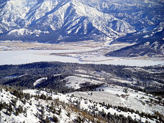
Alpine is a town in Lincoln County, Wyoming, United States. The population was 828 at the 2010 census.

Hells Canyon is a ten-mile-wide (16 km) canyon in the western United States, located along the border of eastern Oregon, a small section of eastern Washington and western Idaho. It is part of the Hells Canyon National Recreation Area which is also located in part of the Wallowa-Whitman National Forest. It is North America's deepest river gorge at 7,993 feet (2,436 m). Notably, Hells Canyon runs deeper than the better-known Grand Canyon in Arizona.

The Green River, located in the western United States, is the chief tributary of the Colorado River. The watershed of the river, known as the Green River Basin, covers parts of the U.S. states of Wyoming, Utah, and Colorado. The Green River is 730 miles (1,170 km) long, beginning in the Wind River Mountains of Wyoming and flowing through Wyoming and Utah for most of its course, except for a short segment of 40 miles (64 km) in western Colorado. Much of the route traverses the arid Colorado Plateau, where the river has carved some of the most spectacular canyons in the United States. The Green is only slightly smaller than the Colorado when the two rivers merge, but typically carries a larger load of silt. The average yearly mean flow of the river at Green River, Utah is 6,121 cubic feet (173.3 m3) per second.

The Gallatin River is a tributary of the Missouri River, approximately 120 mi, in the U.S. states of Wyoming and Montana. It is one of three rivers, along with the Jefferson and Madison, that converge near Three Forks, Montana, to form the Missouri.

Lees Ferry is a site on the Colorado River in Coconino County, Arizona in the United States, about 7.5 miles (12.1 km) southwest of Page and 9 miles (14 km) south of the Utah–Arizona state line.

The Salmon River, also known as "The River of No Return", is a river located in the U.S. state of Idaho in the western United States. It flows for 425 miles (685 km) through central Idaho, draining a rugged, thinly populated watershed of 14,000 square miles (36,000 km2). The river drops more than 7,000 feet (2,100 m) from its headwaters, near Galena Summit above the Sawtooth Valley in the Sawtooth National Recreation Area, to its confluence with the Snake River. Measured at White Bird, its average discharge is 11,060 cubic feet per second. It is one of the largest rivers in the continental United States without a single dam on its mainstem.

The Grande Ronde River is a tributary of the Snake River, 182 miles (293 km) long, in northeastern Oregon and southeastern Washington in the United States. It drains an area southeast of the Blue Mountains and northwest of the Wallowa Mountains, on the Columbia Plateau. It flows through the agricultural Grande Ronde Valley in its middle course and through a series of scenic canyons in its lower course.

The Lewis River is an 18.1-mile-long (29.1 km) tributary of the Snake River. The entire course of the river is located within the boundaries of Yellowstone National Park in Wyoming, US. The river is named for Meriwether Lewis, commander of the Lewis and Clark Expedition.

The Sevier orogeny was a mountain-building event that affected western North America from northern Canada to the north to Mexico to the south.

The Big Maria Mountains are located in the southeastern part of the U.S. state of California, near the Colorado River and Arizona. The range lies between Blythe and Vidal, and west of U.S. Route 95 in California and east of Midland. The mountains are home to the Eagle Nest Mine and reach an elevation of 1,030 meters, (3,379 ft). A power line that runs from Parker Dam to Yuma, Arizona runs through the range. A smaller range, the Little Maria Mountains, lie to the west of the Big Marias.

The Little Maria Mountains are located in southeastern California in the United States. The range lies in a northwest-southeasterly direction east of the Palen Mountains and west of the Big Maria Mountains. The mountain range is approximately 15 miles long and is located about 12.6 miles north of Interstate 10, and 12 miles southwest of the abandoned Rice Army Airfield near State Route 62. The Victor Mine is found at the southeastern end of the range near Midland.

The Greys River is a tributary of the Snake River, flowing through western Wyoming in the United States. The river is about 62 miles (100 km) long, starting high up in the Wyoming Range, 45 miles (72 km) south of the town of Alpine in Lincoln County. The river eventually flows into the Snake River in the Snake River Canyon, joining it just east of Alpine. The Greys River is generally a rushing mountain stream that separates the high Wyoming Range (east) from the Salt River Range (west). It joins the Snake River just above the intersection of U.S. highways 89 and 26. Just a short distance downriver from the confluence of the two rivers, the Snake widens quickly and passes through Alpine and enters the Palisades Reservoir. The largest tributary of the Greys River is the Little Greys River. At Alpine, Wyoming, the Greys River measures 654 cubic feet per second average. With a 180 cuft/s min. and a 3,004 max.

Middle Teton Glacier is on the northeast flank of Middle Teton in Grand Teton National Park, Wyoming. The alpine glacier is a popular mountaineering route for ice climbing and for access to the summit of Middle Teton and other peaks to the south. The glacier is at the west end of Garnet Canyon, which is the most popular route used by climbers ascending Grand Teton. The glacier melt feeds streams below including Spalding Falls, an 80 ft (24 m) high cascade. Between 1967 and 2006, Middle Teton Glacier lost approximately 25 percent of its surface area, shrinking from 52 to 39 acres.

Paintbrush Canyon is located in Grand Teton National Park, in the U. S. state of Wyoming. The canyon was formed by glaciers which retreated at the end of the last glacial maximum approximately 15,000 years ago. The canyon lies between Rockchuck Peak and Mount Saint John to the south and Mount Woodring to the north. Leigh Lake is at the base of the canyon to the east and the alpine Holly Lake is located mid canyon. Popular with hikers, the canyon is part of a popular circuit hike of 19.2 miles (30.9 km) which is rated as very strenuous and includes a total elevation change of 3,845 feet (1,172 m) due to the ascent to Paintbrush Divide 10,720 feet (3,270 m). Views from Paintbrush Divide include Lake Solitude and of Mount Moran to the north and the Cathedral Group including Grand Teton to the south. An ice axe may be necessary for hikes in the early summer. The Paintbrush Canyon Trail is part of the Teton Crest Trail, which spans the southern section of the Teton Range from Teton Pass along Wyoming Highway 22 to String Lake, a total distance of 39 miles (63 km).
The Madison Limestone is a thick sequence of mostly carbonate rocks of Mississippian age in the Rocky Mountain and Great Plains areas of western United States. The rocks serve as an important aquifer as well as an oil reservoir in places. The Madison and its equivalent strata extend from the Black Hills of western South Dakota to western Montana and eastern Idaho, and from the Canada–United States border to western Colorado and the Grand Canyon of Arizona.

The Riverside Mountains are a mountain range in Riverside County, California. The town of Vidal, California is located in the West Riverside Mountains.
The Hoback River, once called the Fall River, is an approximately 55-mile (89 km)-long tributary of the Snake River in the U.S. state of Wyoming. It heads in the northern Wyoming Range of Wyoming and flows northeast, northwest, and then west through the Bridger-Teton National Forest. Its largest tributary is its South Fork, which joins the Hoback about nine miles downstream of its head as it turns northeast and continues to U.S. Route 191. It then turns northwest, where it spreads onto a large marshy flat in a braided floodplain once known as Jackson's Little Hole, but now referred to as the "Hoback Basin" in which lies the town of Bondurant. It then heads west, entering the steep, narrow Hoback Canyon from which it emerges to join the Snake about 11 miles (18 km) south of Jackson Hole, just upstream of head of the Snake River Canyon near the town of Hoback. The entire length of the Hoback is free flowing and unobstructed by dams. About 30 miles (48 km) downstream from the confluence with the Hoback River, the Snake River crosses into the state of Idaho and is impounded by Palisades Dam.
The Snake River Range is located in the U.S. states of Wyoming and Idaho and includes 10 mountains over 9,000 feet (2,700 m). The tallest peak in the range is Mount Baird at 10,030 feet (3,060 m). The range trends northwest to southeast and is bordered on the north by the Teton Range and the two ranges meet at Teton Pass. The Snake River Range is bordered by the Palisades Reservoir to the west and the Snake River, which sweeps completely around the eastern, southern and western part of the range. The range is approximate 30 miles (48 km) north to south and 33 miles (53 km) west to east, covering 528 square miles (1,370 km2). Along the southern boundary, the Snake River passes through Grand Canyon, also known as the Snake River Canyon. U.S. Route 26/U.S. Route 89 follows the course of the Snake River from Hoback Junction to the Palisades Reservoir.


