Snohomish River

Last updated
Snohomish River
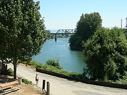
River seen from downtown Snohomish.jpg
Snohomish River in Snohomish, Washington
Snohomishmap.png
Map of the Snohomish River and tributaries
USA Washington relief location map.jpg
Red pog.svg
Mouth of the Snohomish River in Washington
Usa edcp relief location map.png
Red pog.svg
Snohomish River (the United States)
Location
Country United States
State Washington
County Snohomish
Physical characteristics
SourceConfluence of the Skykomish River and the Snoqualmie River
  location Monroe
  coordinates 47°49′48″N122°2′47″W / 47.83000°N 122.04639°W / 47.83000; -122.04639 [1]
Mouth Puget Sound
  location
Port Gardner
  coordinates
48°1′16″N122°12′30″W / 48.02111°N 122.20833°W / 48.02111; -122.20833 [1]
  elevation
0 m (0 ft)
Length20 mi (32 km) [2]
Basin size1,856 sq mi (4,810 km2) [3]
Discharge 
  locationNear Monroe [4]
  average9,511 cu ft/s (269.3 m3/s) [4]
  minimum763 cu ft/s (21.6 m3/s)
  maximum150,000 cu ft/s (4,200 m3/s)

The Snohomish River is a river in Snohomish County, Washington, formed by the confluence of the Skykomish and Snoqualmie rivers near Monroe. It flows northwest entering Port Gardner Bay, part of Puget Sound, between Everett and Marysville. The Pilchuck River is its main tributary and joins the river at Snohomish. The river system drains the west side of the Cascade Mountains from Snoqualmie Pass to north of Stevens Pass.

Contents

Measured at Monroe, the Snohomish River has an average annual flow of 9,500 cubic feet per second (270 m3/s). [2] In comparison, the Columbia River, Washington's largest river, has an average flow of about 265,000 cubic feet per second (7,500 m3/s). [5]

Course

State Route 9 bridge in front of Downtown Snohomish Snohomish River Highway 9 Bridge.jpg
State Route 9 bridge in front of Downtown Snohomish
Debris swept under Airport Way Bridge in Snohomish in November 2006 Snohomish River 26715.JPG
Debris swept under Airport Way Bridge in Snohomish in November 2006

The Snohomish River forms at the confluence of the Snoqualmie and Skykomish Rivers just west of Monroe. Both of these rivers originate in the Cascades and drain the west slopes of the mountains in southeastern Snohomish County and northeastern King County. The Snohomish River flows generally northwestward from the confluence, passing under state route 522 and flowing alongside Lord Hill Regional Park before reaching downtown Snohomish. Here, it is joined by the Pilchuck River, its main tributary, and flows under state route 9. From Snohomish, the river continues northwestward through a broad floodplain, forming the eastern boundary of the city of Everett. The final few miles of the river in Everett form the Snohomish River estuary, a river delta that features wetlands and tideflats spread out across various islands and arms of the river. [6] Several bridges carry U.S. Route 2, Interstate 5, and State Route 529 across the delta. The river then empties into Possession Sound, which is part of Puget Sound, between Everett and Marysville.

Shohomish River pano at Shohomish.jpg
Panoramic view of the Snohomish River from downtown Snohomish

Pollution

The lower Snohomish River was a site of major industry during the 20th century that contaminated the area with various pollutants, including oil and fuel products from former mills and factories. An ore smelter operated by ASARCO contaminated soil and groundwater near the Snohomish River with arsenic. [7] The river has also been used a site for illegal dumping of tires, litter, and batteries. [8] The county government began a program to remove derelict vessels, including old boats, in the Snohomish River delta in 2018; by 2023, the program had removed 27 vessels that had leaked pollutants into the river. [9]

See also

Related Research Articles

<span class="mw-page-title-main">Snohomish County, Washington</span> County in Washington, United States

Snohomish County is a county located in the U.S. state of Washington. With a population of 827,957 as of the 2020 census, it is the third-most populous county in Washington, after nearby King and Pierce counties, and the 72nd-most populous in the United States. The county seat and largest city is Everett. The county forms part of the Seattle metropolitan area, which also includes King and Pierce counties to the south.

<span class="mw-page-title-main">Arlington, Washington</span> City in Washington, United States

Arlington is a city in northern Snohomish County, Washington, United States, part of the Seattle metropolitan area. The city lies on the Stillaguamish River in the western foothills of the Cascade Range, adjacent to the city of Marysville. It is approximately 10 miles (16 km) north of Everett, the county seat, and 40 miles (64 km) north of Seattle, the state's largest city. As of the 2020 U.S. census, Arlington had a population of 19,868; its estimated population is 20,075 as of 2021.

<span class="mw-page-title-main">Granite Falls, Washington</span> City in Washington, United States

Granite Falls is a city in Snohomish County, Washington, United States. It is located between the Pilchuck and Stillaguamish rivers in the western foothills of the Cascade Range, northeast of Lake Stevens and Marysville. The city is named for a waterfall north of downtown on the Stillaguamish River, also accessible via the Mountain Loop Highway. It had a population of 3,364 at the 2010 census.

<span class="mw-page-title-main">Index, Washington</span> Town in Washington, United States

Index is a town in Snohomish County, Washington, United States. The population was 155 at the 2020 census.

<span class="mw-page-title-main">Lake Stevens, Washington</span> City in Washington, United States

Lake Stevens is a city in Snohomish County, Washington, United States, that is named for the lake it surrounds. It is located 6 miles (9.7 km) east of Everett and borders the cities of Marysville to the northwest and Snohomish to the south. The city's population was 35,630 at the 2020 census.

<span class="mw-page-title-main">Marysville, Washington</span> City in Washington, United States

Marysville is a city in Snohomish County, Washington, United States, part of the Seattle metropolitan area. The city is located 35 miles (56 km) north of Seattle, adjacent to Everett on the north side of the Snohomish River delta. It is the second-largest city in Snohomish County after Everett, with a population of 70,714 at the time of the 2020 U.S. census. As of 2015, Marysville was also the fastest-growing city in Washington state, growing at an annual rate of 2.5 percent.

<span class="mw-page-title-main">Monroe, Washington</span> City in Washington, United States

Monroe is a city in Snohomish County, Washington, United States. It is located at the confluence of the Skykomish, Snohomish, and Snoqualmie rivers near the Cascade foothills, about 30 miles (48 km) northeast of Seattle. Monroe's population was 19,699 as of the 2020 census.

<span class="mw-page-title-main">Sultan, Washington</span> City in Washington, United States

Sultan is a city in Snohomish County, Washington, United States. It is located approximately 23 miles (37 km) east of Everett at the confluence of the Skykomish River and the Sultan River, a minor tributary. The city had a population of 5,146 at the 2020 census.

<span class="mw-page-title-main">Snoqualmie River</span> River in northwest Washington, United States

The Snoqualmie River is a 45-mile (72 km) long river in King County and Snohomish County in the U.S. state of Washington. The river's three main tributaries are the North, Middle, and South Forks, which drain the west side of the Cascade Mountains near the town of North Bend and join near the town of Snoqualmie just above the Snoqualmie Falls. After the falls the river flows north through rich farmland and the towns of Fall City, Carnation, and Duvall before meeting the Skykomish River to form the Snohomish River near Monroe. The Snohomish River empties into Puget Sound at Everett. Other tributaries of the Snoqualmie River include the Taylor River and the Pratt River, both of which enter the Middle Fork, the Tolt River, which joins at Carnation, and the Raging River at Fall City.

<span class="mw-page-title-main">Stillaguamish River</span> River in Washington, United States

The Stillaguamish River is a river in the northwestern region of the U.S. state of Washington. It is mainly composed of two forks, the longer North Fork Stillaguamish and the South Fork Stillaguamish. The two forks join near Arlington. From there the Stillaguamish River proper flows for 22 miles (35 km) to Puget Sound. The river's watershed drains part of the Cascade Range north of Seattle.

<span class="mw-page-title-main">Skykomish River</span> River in northwest Washington, United States

The Skykomish River is a 29-mile (47 km) long river in the U.S. state of Washington which drains the west side of the Cascade Mountains in the southeast section of Snohomish County and the northeast corner of King County. The river starts with the confluence of the North Fork Skykomish River and South Fork Skykomish River approximately one mile west of Index, then flowing northwesterly towards Puget Sound. It is joined by the Sultan River and the Wallace River at Sultan. It then meets the Snoqualmie River to form the Snohomish River at Monroe. The Snohomish River continues along the river valley eventually dumping into Port Gardner Bay on Possession Sound.

<span class="mw-page-title-main">Snohomish people</span> Lushootseed-speaking people of Puget Sound

The Snohomish people are a Lushootseed-speaking Southern Coast Salish people who are indigenous to the Puget Sound region of Washington State. Most Snohomish are enrolled in the Tulalip Tribes of Washington and reside on the reservation or nearby, although others are enrolled in other tribes, and some are members of the non-recognized Snohomish Tribe of Indians. Traditionally, the Snohomish occupied a wide area of land, including the Snohomish River, parts of Whidbey and Camano Islands, and the nearby coastline of Skagit Bay and Puget Sound. They had at least 25 permanent villages throughout their lands, but in 1855, signed the Treaty of Point Elliott and were relocated to the Tulalip Reservation. Although some moved to the reservation, the harsh conditions, lack of land, and oppressive policies of the United States government caused many to leave.

<span class="mw-page-title-main">Raging River</span> River in the United States of America

The Raging River is a tributary of the Snoqualmie River in western Washington state in the United States. It is located in the western foothills of the Cascade Mountains in east central King County, Washington. It gets its name from the large amount of water it sometimes carries. The record discharge at the gaging station is over 4,000 cubic feet (110 m3) per second. The Raging is a salmon-bearing river and supports one-fifth of the Snoqualmie River's chinook runs.

<span class="mw-page-title-main">Sultan River</span> Tributary of the Skykomish River, northwest Washington, United States

The Sultan River is a river in Snohomish County in the U.S. state of Washington. It is a tributary of the Skykomish River, which it joins at the town of Sultan, Washington. The river is dammed in its upper third by Culmback Dam to form Spada Lake.

<span class="mw-page-title-main">Culmback Dam</span> Dam in Snohomish County, Washington

The Culmback Dam is a large rockfill hydroelectric and water supply dam on the Sultan River, a tributary of the Skykomish River, in Washington. Built in 1965, the dam is 640 feet (200 m) long at the crest and 262 feet (80 m) high. Its reservoir, Spada Lake, provides water for 70 to 75 percent of Snohomish County and feeds the Jackson Hydro Project, providing 112 megawatts of clean energy to Snohomish county. Some critics charge that the dam has strongly impacted the runs of salmon and other migratory fish in the Sultan River by depleting gravel and sediment needed to line the riverbed. The dam's operator counters that Culmback Dam dramatically reduces flooding events, benefiting fish populations and the surrounding communities. The dam was named in honor of George Culmback, a former mayor of Everett.

The Scenic Subdivision or Scenic Sub is a railroad line running about 155 miles (249 km) from Seattle, Washington to Wenatchee, Washington. It is operated by BNSF Railway as part of their Northern Transcon. This route includes the Cascade Tunnel, as well as the 1893 site of the "last spike" near Scenic, Washington, which marked the completion for the Great Northern Railway transcontinental railway line built by James J. Hill.

The Tye River is a river in the U.S. state of Washington. It rises near Stevens Pass in the Cascade Mountains and flows west, joining the Foss River to form the South Fork Skykomish River. Its waters eventually empty into Puget Sound near Everett via the Skykomish River and Snohomish River. U.S. Route 2 follows the river's entire length. A BNSF Railway line follows most of the river except near the pass where the tracks use the Cascade Tunnel. Powerlines run by the Bonneville Power Administration (BPA) follow the Tye River west of Tunnel Creek.

The Foss River is a stream in the U.S. state of Washington. It has two main forks, the East Fork Foss River and the West Fork Foss River. The main stem is formed by the confluence of the two forks. The river and its forks rise near in the Alpine Lakes Wilderness area of Mount Baker-Snoqualmie National Forest in the Cascade Mountains and flows generally north, joining the Tye River to form the South Fork Skykomish River. The Foss River's waters eventually empty into Puget Sound near Everett via the Skykomish River and Snohomish River.

<span class="mw-page-title-main">Snoqualmie people</span>

The Snoqualmie people are a Lushootseed-speaking Southern Coast Salish people indigenous to the Snoqualmie Valley, located in east King and Snohomish counties in the state of Washington.

<span class="mw-page-title-main">Skykomish people</span> Lushootseed-speaking people in Washington (state)

The Skykomish are a Lushootseed-speaking Coast Salish people indigenous to the Skykomish Valley in the Cascade Mountains of Washington.

References

  1. 1 2 U.S. Geological Survey Geographic Names Information System: Snohomish River
  2. 1 2 Snohomish River Watershed Draft Initial Assessment Archived 2006-10-04 at the Wayback Machine
  3. Surface Water Management Division: Snohomish River Salmon Recovery
  4. 1 2 USGS Snohomish River gauge near Monroe
  5. Kammerer, J.C. (May 1990). "Largest Rivers in the United States". U.S. Geological Survey. Retrieved 2008-04-01.
  6. Brennick, Charles. "Snohomish River Estuary Recreation Guide". Snohomish County Estuary. Snohomish County government . Retrieved July 11, 2019.
  7. Sanders, Julia-Grace (September 30, 2020). "Port of Everett's next cleanup will bring jobs, public access". The Everett Herald. Retrieved December 30, 2023.
  8. Bryan, Zachariah (May 22, 2022). "Diving for trash in Snohomish River, biologist fills 59 pickup beds". The Everett Herald. Retrieved December 30, 2023.
  9. Van Sistine, Ta'Leah (December 30, 2023). "'My river': Locals take it upon themselves to clean up the Snohomish". The Everett Herald. Retrieved December 30, 2023.