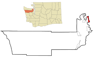
Marrowstone is a census-designated place (CDP) in Jefferson County, Washington, United States. The population was 844 at the 2010 census. All Marrowstone addresses are in Nordland, Washington, and the ZIP code for Marrowstone Island is 98358.

Admiralty Inlet is a strait in the U.S. state of Washington connecting the eastern end of the Strait of Juan de Fuca to Puget Sound. It lies between Whidbey Island and the northeastern part of the Olympic Peninsula.

Mukilteo Lighthouse Park encompasses the lighthouse at the west end of the city of Mukilteo, Washington, and 12 acres (0.049 km2) south of it. The property is west and south of the Washington State Ferries terminal with ferry service to Clinton, Whidbey Island, and is bordered on the south and east by the BNSF Railway mainline. Whidbey Island lies across a narrow portion of Possession Sound and is easily visible from the shore.

Point Wilson is at the end of the Quimper Peninsula, a northeast extension of the Olympic Peninsula and the northeasternmost point of Jefferson County, Washington, United States, approximately two miles north of the Port Townsend business district.
Point Partridge is the most westerly point of Whidbey Island, the largest island in Puget Sound. The point lies north of the Fort Ebey military reservation and south of West Beach. The primary importance of Point Partridge is as the northern and eastern reference point for the dividing line between Puget Sound and the Strait of Juan de Fuca. The other reference is Point Wilson.

Discovery Bay is a small bay connected to the Strait of Juan de Fuca on the Olympic Peninsula in Washington state; it was also historically called Port Discovery. An unincorporated community also named Discovery Bay lies in Jefferson County at the southern end of the bay.

Gardiner is an unincorporated community in Jefferson County, Washington, United States.
The Quimper Peninsula is a narrow peninsula forming the most northeastern extent of the Olympic Peninsula of Washington state in the northwestern United States of America.
Beckett Point is a small sand spit jutting out into northeastern Discovery Bay, about ten miles from the city of Port Townsend in Jefferson County, Washington, United States. The Point is owned by the Beckett Point Fisherman's Club, which leases out approximately 100 homes. Many of the families have lived there for several generations, fishing salmon, crab, and shrimp.

Possession Sound is part of Puget Sound, located in the U.S. state of Washington between Whidbey Island and the shoreline of Snohomish County approximately between the cities of Everett and Mukilteo. Possession Sound connects the main Puget Sound basin to the south with Saratoga Passage and Port Susan to the north. The Snohomish River flows into Possession Sound at Port Gardner Bay. Gedney Island, also called Hat Island, is located in Possession Sound.

Saratoga Passage lies in Puget Sound between Whidbey Island and Camano Island.

Bellingham Bay is a bay of the Salish Sea located in Washington State in the United States. It is separated from the Strait of Georgia on the west by the Lummi Peninsula, Portage Island, and Lummi Island. It is bordered on the east by Bellingham, Washington, to the south-east by the Chuckanut Mountains, and to the south by Samish Bay. The Nooksack River empties into the bay, as does Whatcom Creek.
Skagit Bay is a bay and strait located in the U.S. state of Washington. It is part of the Whidbey Island Basin of Puget Sound. The Skagit River empties into Skagit Bay. To the south, Skagit Bay connects with the rest of Puget Sound via Saratoga Passage and Possession Sound. The boundary between Saratoga Passage and Skagit Bay is between Polnell Point on Whidbey Island and Rocky Point on Camano Island. To the northwest, Skagit Bay connects to the Strait of Juan de Fuca via the narrow strait of Deception Pass. A third waterway, the Swinomish Channel, connects Skagit Bay with Padilla Bay to the north.
Port Susan is a bay and strait located in the U.S. state of Washington. Part of the Whidbey Island Basin of Puget Sound, Port Susan is bounded by Camano Island to the west and the mainland to the east. The Stillaguamish River empties into the northern end of Port Susan. To the south, Port Susan connects with the rest of Puget Sound via Possession Sound and Saratoga Passage. A swampy waterway connects the northern end of Port Susan with Skagit Bay. This waterway also separates Camano Island from the mainland.
USNS Sgt. George Peterson (T-AK-248) was a US Maritime Administration (MARCOM) C1-M-AV1 type coastal cargo ship, originally planned as an Alamosa-class cargo ship. The contract for building was canceled by the Navy in August 1945. The ship, however, was completed as SS Coastal Guide. She was later acquired by the US Army, in 1948, and renamed USAT Sgt. George Peterson. She was reacquired by the Navy, in 1950, and placed in service by the Military Sea Transportation Service (MSTS) as USNS Sgt. George Peterson (T-AK-248). She remained with the Navy until struck in 1966. She was sold in 1971.

The Puget Sound region is a coastal area of the Pacific Northwest in the U.S. state of Washington, including Puget Sound, the Puget Sound lowlands, and the surrounding region roughly west of the Cascade Range and east of the Olympic Mountains. It is characterized by a complex array of saltwater bays, islands, and peninsulas carved out by prehistoric glaciers.
From 1577 to 1580 Sir Francis Drake circumnavigated the world. In 1579 as part of this voyage he landed on the west coast of North America which consequently has drawn the attention of scores of historians, geographers, linguists, anthropologists and other professionals. In addition, many history buffs have sought to locate Drake's New Albion. The established site for Drake's 1579 landing at New Albion is at Drake's Cove in Drakes Bay in Marin County, California. More than a score of ideas for an alternative to Drake's New Albion claim have been put forth which cover the coast from Alaska to Baja California Sur, Mexico. These ideas span the eighteenth through the early twenty-first centuries.
Jonestown is an unincorporated community in Howard County, Maryland, United States.
