
Puget Sound is a sound of the Pacific Northwest, an inlet of the Pacific Ocean, and part of the Salish Sea. It is located along the northwestern coast of the U.S. state of Washington. It is a complex estuarine system of interconnected marine waterways and basins, with one major and two minor connections to the open Pacific Ocean via the Strait of Juan de Fuca—Admiralty Inlet being the major connection and Deception Pass and Swinomish Channel being the minor.
The Puyallup River is a river in the U.S. state of Washington. About 45 miles (72 km) long, it is formed by glaciers on the west side of Mount Rainier. It flows generally northwest, emptying into Commencement Bay, part of Puget Sound. The river and its tributaries drain an area of about 948 square miles (2,460 km2) in Pierce County and southern King County.

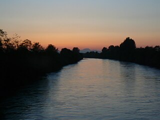
The Nisqually River is a river in west central Washington in the United States, approximately 81 miles (130 km) long. It drains part of the Cascade Range southeast of Tacoma, including the southern slope of Mount Rainier, and empties into the southern end of Puget Sound. Its outlet was designated in 1971 as the Nisqually Delta National Natural Landmark.

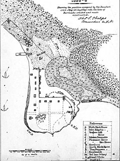
Fort Nisqually was an important fur trading and farming post of the Hudson's Bay Company in the Puget Sound area, part of the Hudson's Bay Company's Columbia Department. It was located in what is now DuPont, Washington. Today it is a living history museum located in Tacoma, Washington, USA, within the boundaries of Point Defiance Park. The Fort Nisqually Granary, moved along with the Factor's House from the original site of the second fort to this park, is a U.S. National Historic Landmark. Built in 1843, the granary is the oldest building in Washington state and one of the only surviving examples of a Hudson's Bay Company "post on sill" structure. The Factor's House and the granary are the only surviving Hudson's Bay Company buildings in the United States.
The Puget Sound War was an armed conflict that took place in the Puget Sound area of the state of Washington in 1855–56, between the United States military, local militias and members of the Native American tribes of the Nisqually, Muckleshoot, Puyallup, and Klickitat. Another component of the war, however, were raiders from the Haida and Tlingit who came into conflict with the United States Navy during contemporaneous raids on the native peoples of Puget Sound. Although limited in its magnitude, territorial impact and losses in terms of lives, the conflict is often remembered in connection to the 1856 Battle of Seattle and to the wrongful execution of a central figure of the war, Nisqually Chief Leschi. The contemporaneous Yakima War may have been responsible for some events of the Puget Sound War, such as the Battle of Seattle, and it is not clear that the people of the time made a strong distinction between the two conflicts.

Lake Chicago was a prehistoric proglacial lake that is the ancestor of what is now known as Lake Michigan, one of North America's five Great Lakes. Fed by retreating glaciers, it drained south through the Chicago Outlet River.

Lake Maumee was a proglacial lake and an ancestor of present-day Lake Erie. It formed about 14,000 Years Before Present (YBP) as the Huron-Erie Lobe of the Laurentide Ice Sheet retreated at the end of the Wisconsin glaciation. As water levels continued to rise the lake evolved into Lake Arkona and then Lake Whittlesey.
The Treaty of Medicine Creek was an 1854 treaty between the United States, and nine tribes and bands of Indians, occupying the lands lying around the head of Puget Sound, Washington, and the adjacent inlets. The tribes listed on the Treaty of Medicine Creek are Nisqually, Puyallup, Steilacoom, Squawskin, S'Homamish, Stehchass, T'Peeksin, Squi-aitl, and Sa-heh-wamish. The treaty was signed on December 26, 1854, by Isaac I. Stevens, governor and superintendent of Indian Affairs of the territory at the time of the signing, along with the chiefs, head-men and delegates of the stated tribes. For the purpose of the treaty, these representatives who signed the treaty were stated to have been, "regarded as one nation, on behalf of said tribes and bands, and duly authorized by them."

The Nisqually Glacier is one of the larger glaciers on the southwestern face of Mount Rainier in the U.S. state of Washington. The glacier is one of the most easily viewed on the mountain, and is accessible from the Paradise visitor facilities in Mount Rainier National Park. The glacier has had periods of advance and retreat since 1850 when it was much more extensive. It is currently retreating. Measurements made at 9,200 feet (2,800 m) altitude show that glacier got 56 ft (17 m) thicker between 1994 and 1997, suggesting that it will probably begin advancing in the first decade of the 21st century. Nisqually Glacier is the source of the Nisqually River.

The glacial history of Minnesota is most defined since the onset of the last glacial period, which ended some 10,000 years ago. Within the last million years, most of the Midwestern United States and much of Canada were covered at one time or another with an ice sheet. This continental glacier had a profound effect on the surface features of the area over which it moved. Vast quantities of rock and soil were scraped from the glacial centers to its margins by slowly moving ice and redeposited as drift or till. Much of this drift was dumped into old preglacial river valleys, while some of it was heaped into belts of hills at the margin of the glacier. The chief result of glaciation has been the modification of the preglacial topography by the deposition of drift over the countryside. However, continental glaciers possess great power of erosion and may actually modify the preglacial land surface by scouring and abrading rather than by the deposition of the drift.

Sequalitchew Creek, located in DuPont, Washington emanates from Sequalitchew Lake, Fort Lewis, Washington, was the location of the original Fort Nisqually trading post established in 1833 by the Hudson's Bay Company. The historic, natural flow of Sequalitchew Creek runs from Sequalitchew Lake, through Edmonds Marsh, down the canyon and out to the Puget Sound.

Lake Kankakee formed 14,000 years before present (YBP) in the valley of the Kankakee River. It developed from the outwash of the Michigan Lobe, Saginaw Lobe, and the Huron-Erie Lobe of the Wisconsin glaciation. These three ice sheets formed a basin across Northwestern Indiana. It was a time when the glaciers were receding, but had stopped for a thousand years in these locations. The lake drained about 13,000 YBP, until reaching the level of the Momence Ledge. The outcropping of limestone created an artificial base level, holding water throughout the upper basin, creating the Grand Kankakee Marsh.

Lake Kapowsin is a lake in Pierce County, Washington, about halfway between Tacoma on Puget Sound, and Mount Rainier in the Cascade Mountains. The lake is 2.5 miles (4.0 km) long and 0.15–0.5 miles (0.24–0.80 km) wide, lying in a channel formed by meltwater from the Puget lobe of the Vashon glacier during the Pleistocene glaciation. A small unnamed island lies in the northern half of the lake. As indicated by a drowned forest in the lake and other evidence, the Puyallup River was inundated about 550 years ago by a lahar from Mount Rainier called the Electron Mudflow. The mudflow partially filled the channel and blocked Ohop Creek's outlet, forming present-day Lake Kapowsin.

The Vashon Glaciation, Vashon Stadial or Vashon Stade is a local term for the most recent period of very cold climate in which during its peak, glaciers covered the entire Puget Sound and Strait of Juan de Fuca as well as present day Seattle, Tacoma, Olympia and other surrounding areas in the western part of present-day Washington (state) of the United States of America. This occurred during a cold period around the world known as the last glacial period. This was the most recent cold period of the Pleistocene Ice Age. The Pleistocene Glaciation is the ice age that the planet is currently in and has been in for the last 2.58 million years. It is the time period in which the arctic ice sheets have existed. The Pleistocene Ice Age is part of an even longer ice age called the Late Cenozoic Ice Age, which began 33.9 million years ago and is ongoing. It is the time period in which the Antarctic ice cap has existed.
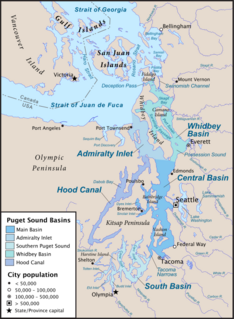
South Puget Sound is the southern reaches of Puget Sound in Southwest Washington, in the United States' Pacific Northwest. It is one of five major basins encompassing the entire Sound, and the shallowest basin, with a mean depth of 37 meters (121 ft). Exact definitions of the region vary: the state's Department of Fish and Wildlife counts all of Puget Sound south of the Tacoma Narrows for fishing regulatory purposes. The same agency counts Mason, Jefferson, Kitsap, Pierce and Thurston Counties for wildlife management. The state's Department of Ecology defines a similar area south of Colvos Passage.
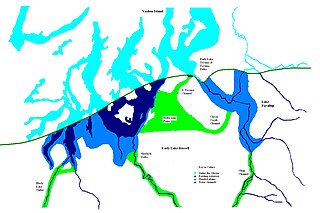
During the Vashon Glaciation a series of lakes formed along the southern margin of the Cordilleran Ice Cap. In the Puget Sound depression, a series of lakes developed, of which Lake Russell was the largest and the longest lasting. Early Lake Russell’s surface was at 160 ft (49 m) above sea level, draining across the divide at Shelton, Washington into early Glacial Lake Russell. When the ice margin receded northward, the lake expanded. When it reached the Clifton channel outlet, the water levels dropped to 120 ft (37 m) above sea level. The new longer and lower level lake is referred to as Lake Hood. The glacier continued to retreat until the northern outlet of the Hood Canal was reached as the water level equalized with Glacial Lake Russell becoming part of that body of water.

During the Vashon Glaciation a series of lakes formed along the southern margin of the Cordilleran Ice Cap. In the Hood Canal depression, two significant lake stages existed, Lake Skokomish and Lake Hood. Early Lake Skokomish’s surface was at 350 ft (110 m) above sea level, draining across the divide at Shelton, Washington into early Glacial Lake Russell. As the glacier receded northward, this freshwater lake grew in size, until the ice was north of the Clifton channel. With the opening of the Clifton channel, the water dropped to 160 m (520 ft) above sea level. This longer and lower level lake is referred to as Lake Hood. The glacier continued to recede northward until it reached the Poulsbo channel. Here, the water level equalized to Glacial Lake Russell nolonger having a separate identify.
Lake Puyallup developed along the south edge of the Puget Sound Glacier. The glacier was in retreat northward after having reached its most southerly point. Drainage off the north face of Mount Rainier and the melting ice of the glacier was trapped in the valley of the Puyallup River. As the glacier moved north, the lake grew until it reached its largest capacity with the glacier at the glacial front across the Puyallup valley just south of Commencement Bay at Tacoma and northern bend of the White River at Auburn. When the ice retreated further north, it was reduced in depth and volume and takes on the name of Lake Tacoma.

Lake Tacoma is the name given the freshwater lake in the basin of the Puyallup River and the Green River at the point in time that the Vashon Glacier had receded northward into Commencement Bay. Prior to this, it was referred to as the Lake Puyallup. The bluff on which this city is built is used as the landmark where Lake Puyallup ceased and it became Lake Tacoma.
