Somerset Victoria County History

Last updated

The Somerset Victoria County History is an encyclopaedic history of the county of Somerset in England, forming part of the overall Victoria County History of England founded in 1899 in honour of Queen Victoria. With ten volumes published in the series A History of the County of Somerset, the Somerset VCH is among the most substantial of the Victoria County Histories.

County Geographical and administrative region in some countries

A county is a geographical region of a country used for administrative or other purposes, in certain modern nations. The term is derived from the Old French conté or cunté denoting a jurisdiction under the sovereignty of a count (earl) or a viscount. The modern French is comté, and its equivalents in other languages are contea, contado, comtat, condado, Grafschaft, graafschap, Gau, etc..

Somerset County of England

Somerset is a county in South West England which borders Gloucestershire and Bristol to the north, Wiltshire to the east, Dorset to the south-east and Devon to the south-west. It is bounded to the north and west by the Severn Estuary and the Bristol Channel, its coastline facing southeastern Wales. Its traditional border with Gloucestershire is the River Avon. Somerset's county town is Taunton.

England Country in north-west Europe, part of the United Kingdom

England is a country that is part of the United Kingdom. It shares land borders with Wales to the west and Scotland to the north-northwest. The Irish Sea lies west of England and the Celtic Sea lies to the southwest. England is separated from continental Europe by the North Sea to the east and the English Channel to the south. The country covers five-eighths of the island of Great Britain, which lies in the North Atlantic, and includes over 100 smaller islands, such as the Isles of Scilly and the Isle of Wight.

Contents

Volumes published

General volumes

Plan of St Michael's Hill, Montacute, from Volume II (1911) StMichaels Hill Montacute Somerset Map.jpg
Plan of St Michael's Hill, Montacute, from Volume II (1911)

William Page was a prolific and pioneering historian and editor. For the last three decades of his life he was general editor of the Victoria County History.

Domesday Book 11th-century survey of landholding in England as well as the surviving manuscripts of the survey

Domesday Book is a manuscript record of the "Great Survey" of much of England and parts of Wales completed in 1086 by order of King William the Conqueror. The Anglo-Saxon Chronicle states:

Then, at the midwinter [1085], was the king in Gloucester with his council .... After this had the king a large meeting, and very deep consultation with his council, about this land; how it was occupied, and by what sort of men. Then sent he his men over all England into each shire; commissioning them to find out "How many hundreds of hides were in the shire, what land the king himself had, and what stock upon the land; or, what dues he ought to have by the year from the shire."

Wells Cathedral Anglican cathedral in Wells, Somerset, England

Wells Cathedral is an Anglican cathedral in Wells, Somerset, England, dedicated to St Andrew the Apostle and seat of the Bishop of Bath and Wells, whose throne or cathedra it holds as mother church of the diocese. Built between 1175 and 1490 to replace an earlier church on the site since 705, it is moderately sized for an English cathedral. Its broad west front and large central tower are dominant features in the city and countryside. It has been called "unquestionably one of the most beautiful" and "most poetic" of English cathedrals. Its Gothic architecture is mostly in the Early English style of the late 12th–early 13th centuries, lacking the Romanesque work that survives in many other cathedrals. Building began about 1175 at the east end with the choir. Historian John Harvey sees it as Europe's first truly Gothic structure, breaking with the last constraints of Romanesque. The stonework of its pointed arcades and fluted piers bears pronounced mouldings and carved capitals in a foliate, "stiff leaf" style. Its Early English front with 300 sculpted figures, is described as a "supreme triumph of the combined plastic arts in England". The east end retains a rare amount of ancient stained glass. Unlike many cathedrals of monastic foundation, Wells has many surviving secular buildings linked to its chapter of secular canons, including the Bishop's Palace and the 15th-century residential Vicars' Close. The cathedral is a Grade I listed building.

Topographical volumes

Huish Episcopi village in the United Kingdom

Huish Episcopi is a village and civil parish in Somerset, England, situated on the outskirts of Langport, 4 miles (6.4 km) south west of Somerton in the South Somerset district. The parish has a population of 2,095, and includes the hamlets of Bowdens, Combe, Pibsbury and Wearne.

Langport a town in South Somerset, United Kindom

Langport is a small town and civil parish in Somerset, England, 5 miles (8.0 km) west of Somerton in the South Somerset district. The parish has a population of 1,081. Langport is contiguous with Huish Episcopi, a separate parish that includes much of the town's outskirts.

Muchelney human settlement in United Kingdom

Muchelney is a clustered village and civil parish in Somerset, England, extending for 3 kilometres (1.9 mi) from the south bank of the River Parrett and that has a clustered centre. This is 1 mile (1.6 km) south of Huish and Langport and 4 miles (6.4 km) south west of Somerton in the South Somerset district. Its elevations range from 8 to 12 metres AOD. Muchelney has some orchards and a copse of remaining woodland in the centre-south covering between 2 and 5% of the land.

County Editors

The present county editor, Mary C. Siraut, served as deputy editor from 1978 to 2006 and was a full-time VCH employee until March 2011, when because of a funding shortfall she took early retirement. She is continuing work on the project on a part-time basis and is based at the new Somerset Heritage Centre in Norton Fitzwarren. [12] [13]

Norton Fitzwarren farm village in the United Kingdom

Norton Fitzwarren is a village, electoral ward, and civil parish in Somerset, England, situated 2 miles (3.2 km) north west of Taunton in the Taunton Deane district. The village has a population of 3,046.

Deputy County Editors

See also

History of Somerset

Somerset is a historic county in the south west of England. There is evidence of human occupation since prehistoric times with hand axes and flint points from the Palaeolithic and Mesolithic eras, and a range of burial mounds, hill forts and other artefacts dating from the Neolithic, Bronze and Iron Ages. The oldest dated human road work in Great Britain is the Sweet Track, constructed across the Somerset Levels with wooden planks in the 39th century BCE.

The Somerset Buildings Preservation Trust (SBPT) works to save the architectural heritage of Somerset, England.

Wiltshire Victoria County History

The Wiltshire Victoria County History, properly called The Victoria History of the County of Wiltshire but commonly referred to as VCH Wiltshire, is an encyclopaedic history of the county of Wiltshire in England. It forms part of the overall Victoria County History of England founded in 1899 in honour of Queen Victoria. With eighteen volumes published in the series, it is now the most substantial of the Victoria County Histories.

Related Research Articles

Charlton Musgrove village in the United Kingdom

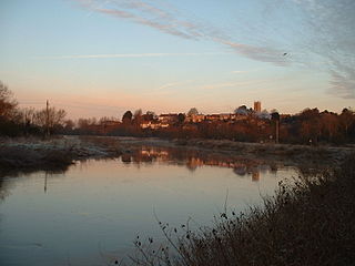
Charlton Musgrove is a village and civil parish in Somerset, England, situated 1 mile (1.6 km) north east of Wincanton in the South Somerset district. The village has a population of 398. The parish includes the hamlets of Barrow, Holbrook, Southmarsh, and part of Shalford.

Seavington St Michael a village located in South Somerset, United Kingdom

Seavington St Michael is a village and civil parish in Somerset, England. It is situated next to the village of Seavington St Mary, about 3 miles (4.8 km) east of Ilminster, within the South Somerset district. It lies in a hollow within a larger area of low-lying hills and valleys running broadly east-west. A part of the South Petherton Hundred, originally the area included seven settlements which have gradually merged or vanished, but were the origin of the Seavington -- part of the village name.

East Huntspill human settlement in the United Kingdom

East Huntspill is a village and civil parish on the Huntspill Level, near Highbridge, Somerset, England. The civil parish includes Cote, Hackness and Bason Bridge.

Court House, East Quantoxhead Grade I listed house in West Somerset, United Kingdom

The Court House in East Quantoxhead, Somerset, England has a medieval tower and other parts of the building which date from the 17th century. It has been designated as a grade I listed building.

Church of St Mary, North Petherton church in Sedgemoor, UK

The Church of St Mary in North Petherton, Somerset, England dates from the 15th century and has been designated as a grade I listed building. It is on the Heritage at Risk register due to the condition of the roof and north aisle parapet.

Hundred of Andersfield

The Hundred of Andersfield is one of the 40 historical Hundreds in the ceremonial county of Somerset, England, dating from before the Norman conquest during the Anglo-Saxon era although exact dates are unknown.

Hundred of North Petherton

The Hundred of North Petherton is one of the 40 historical Hundreds in the ceremonial county of Somerset, England, dating from before the Norman conquest. Although the Hundreds have never been formally abolished, their functions ended with the establishment of county courts in 1867 and the introduction of districts by the Local Government Act 1894. The name of the hundred derives from the name of the large royal estate that covered much of the area in 1086, recorded variously as Nortpetret in the Domesday Book, Nortpedret in Liber Exoniensis and Nort Peretu in the associated tax returns. This, in turn, was derived from the area's location to the northern end of the River Parrett.

The Hundred of South Petherton is one of the 40 historical Hundreds in the ceremonial county of Somerset, England, dating from before the Norman conquest during the Anglo-Saxon era although exact dates are unknown. Each hundred had a 'fyrd', which acted as the local defence force and a court which was responsible for the maintenance of the frankpledge system. They also formed a unit for the collection of taxes. The role of the hundred court was described in the Dooms (laws) of King Edgar. The name of the hundred was normally that of its meeting-place.

Horsington House

Horsington House is a country house in Horsington, near Templecombe in Somerset. It is a stone-built house with pillared porch, built in 1839. It is a Grade II listed building.

Petherton Park

Petherton Park was a Deer park around North Petherton within the English county of Somerset.

Manor of Sydenham

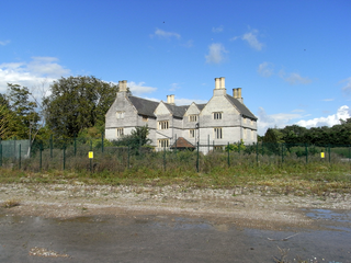
The Manor of Sydenham was a historic manor in Somerset, England, situated about 1/4 mile north-east of the centre of historic Bridgwater. Sydenham House, the manor house, a grade II listed building situated in the parish of Wembdon, was built in the early 16th century and refronted and rebuilt after 1613. In 1937 British Cellophane Ltd set up production and built extensive factories on 59 acres of land adjacent to the manor house. Production ceased in 2005 and between 2010 and 2015 the industrial site was razed to the ground. In 2015 the razed site is owned by EDF Energy, which in 2012 purchased the manor house with the former factory site, intended for construction of temporary accommodation for 1,000 workers on the proposed new Hinkley Point C nuclear power station 12 miles away. The Manor House is situated to the north side of the A39 Bath Road. Its owners were on the losing side in the Civil War and again in the Monmouth Rebellion.

Church of St Giles, Thurloxton

The Norman Anglican Church of St Giles in Thurloxton dates from the 14th century but is predominantly from the 15th century with 19th-century restoration including the addition of the north aisle in 1868. It has been designated by English Heritage as a Grade II* listed building.

West Bower Manor

West Bower Manor in Durleigh within the English county of Somerset was largely built in the 15th century. It is a Grade II* listed building.

Church of St Hugh, Durleigh

The Church of St Hugh at Durleigh in the English county of Somerset was built in the 11th century. It is a Grade II* listed building.

Church of St Peter, North Newton church in Sedgemoor, UK

The Anglican Church of St Peter in North Newton within the English county of Somerset has a tower believed to date from Saxon times. It is a Grade II* listed building.

Church of the Holy Trinity, Chilton Trinity

The Anglican Church of the Holy Trinity at Chilton Trinity in the English county of Somerset was established in the 13th century. It is a Grade II* listed building.

Church of St Mary, East Quantoxhead

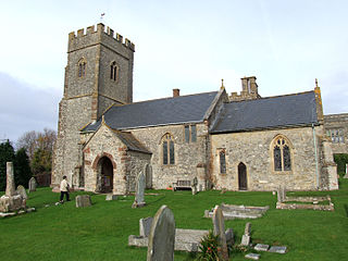
The Anglican Church of St Mary in East Quantoxhead, Somerset, England was built in the 14th century. It is a Grade II* listed building.

Church of St Mary, Brompton Ralph

The Anglican Church of St Mary in Brompton Ralph, Somerset, England was built in the 15th century. It is a Grade II* listed building.

References

  1. A History of the County of Somerset: Volume 1 at british-history.ac.uk, accessed 28 October 2011
  2. 1 2 Victoria County History: Somerset at british-history.ac.uk, accessed 28 October 2011
  3. 1 2 3 4 5 6 7 8 9 10 Somerset Publications at victoriacountyhistory.ac.uk, accessed 28 October 2011
  4. A History of the County of Somerset: Volume 2 at british-history.ac.uk, accessed 28 October 2011
  5. A History of the County of Somerset: Volume 3 at british-history.ac.uk, accessed 28 October 2011
  6. A History of the County of Somerset: Volume 4 at british-history.ac.uk, accessed 28 October 2011
  7. A History of the County of Somerset: Volume 5 at british-history.ac.uk, accessed 28 October 2011
  8. A History of the County of Somerset: Volume 6 at british-history.ac.uk, accessed 28 October 2011
  9. A History of the County of Somerset: Volume 7 at british-history.ac.uk, accessed 28 October 2011
  10. A History of the County of Somerset: Volume 8 at british-history.ac.uk, accessed 28 October 2011
  11. A History of the County of Somerset: Volume 9 at british-history.ac.uk, accessed 28 October 2011
  12. 1 2 About VCH Somerset at victoriacountyhistory.ac.uk, accessed 28 October 2011
  13. Elizabeth Williamson, HARD TIMES AND GREEN SHOOTS (2011) at balh.co.uk, accessed 28 October 2011