
The Titfield Thunderbolt is a 1953 British comedy film directed by Charles Crichton and starring Stanley Holloway, Naunton Wayne, George Relph and John Gregson. The screenplay concerns a group of villagers trying to keep their branch line operating after British Railways decided to close it. The film was written by T.E.B. Clarke and was inspired by the restoration of the narrow gauge Talyllyn Railway in Wales, the world's first heritage railway run by volunteers. "Titfield" is an amalgamation of the names Titsey and Limpsfield, two villages in Surrey near Clarke's home at Oxted.

Wassail is a beverage made from hot mulled cider and spices, drunk traditionally as an integral part of wassailing, an ancient English Yuletide drinking ritual and salutation either involved in door-to-door charity-giving or used to ensure a good cider apple harvest the following year.

The Somerset Coal Canal was a narrow canal in England, built around 1800. Its route began in basins at Paulton and Timsbury, ran to nearby Camerton, over two aqueducts at Dunkerton, through a tunnel at Combe Hay, then via Midford and Monkton Combe to Limpley Stoke where it joined the Kennet and Avon Canal. This link gave the Somerset coalfield access east toward London. The longest arm was 10.6 miles (17.1 km) long with 23 locks. From Midford an arm also ran via Writhlington to Radstock, with a tunnel at Wellow.

North East Somerset is a constituency represented in the House of Commons of the UK Parliament, since its 2010 creation, by Jacob Rees-Mogg, a Conservative currently serving as Minister for Brexit Opportunities & Government Efficiency

Midford is a village approximately 3 miles (5 km) south-south-east of Bath, Somerset, England. Although relatively small, it extends over 2 counties, is part of two unitary authorities and is part of five parishes. Although all five parishes extend very near to the village centre, most of the residents reside in the parish of Southstoke and are part of the Bath and North East Somerset unitary authority.
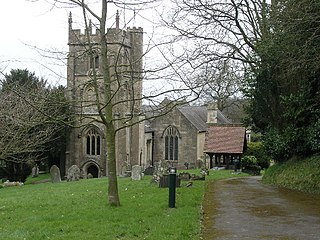
Camerton is a village and civil parish in Somerset, 6 miles (9.7 km) south west of Bath, lying on the Cam Brook. The parish has a population of 655.

Wellow is a village and civil parish in Somerset, England, about 5 miles (8.0 km) south of Bath. The parish, which includes the hamlets of Twinhoe, White Ox Mead, Baggridge and part of Midford has a population of 529. The village itself falls within the southernmost boundary of the Cotswolds Area of Outstanding Natural Beauty and is recognised as having special architectural and historic interest, which led to it being designated as a Conservation Area in 1983.
Clutton is a village and civil parish on the eastern edge of the affluent Chew Valley, close to the Cam Brook river, in the Bath and North East Somerset Council area, within the ceremonial county of Somerset, and straddles both the A37 and A39. It is located 9 miles (14 km) from Bristol and Bath, and 11 miles (18 km) from Wells. Nearby are the villages of Temple Cloud, High Littleton and Chelwood. The town of Midsomer Norton is 5 miles (8 km) away. The parish, which includes the hamlets of Clutton Hill and Northend has a population of 1,602.

Limpley Stoke is a village and civil parish in Wiltshire, England. It lies in the Avon valley between Bath and Freshford, and is both above and below the A36 road.

High Littleton is a village and civil parish in Somerset, England, about 1.2 miles (1.9 km) north of Paulton and 7.5 miles (12 km) south-west of Bath. The parish includes the small village of Hallatrow and the hamlets of White Cross, Greyfield and Mearns; the northeastern part of High Littleton village is known as Rotcombe.

Midford railway station was a single-platform station on the Bath extension of the Somerset and Dorset Railway, just to the north of the point where the double-track became a single track. It served the village of Midford. The station was closed with the rest of the line in March 1966 under the Beeching axe, though it had been unstaffed for some years before that.

Long Dole Wood and Meadows SSSI is a 9.8 hectares biological Site of Special Scientific Interest (SSSI) between the villages of Farrington Gurney and Hinton Blewitt in Bath and North East Somerset, notified in 1987.

The Stoney Littleton Long Barrow is a Neolithic chambered tomb with multiple burial chambers, located near the village of Wellow in the English county of Somerset. It is an example of the Cotswold-Severn Group and was scheduled as an ancient monument in 1882. It was one of the initial monuments included when the Ancient Monuments Protection Act 1882 became law.

The Wellow Brook is a small river in Somerset, England.

The River Somer is a small river in Somerset, England.

Midford Brook is a small river in Somerset, England.

The Somerset Coalfield in northern Somerset, England is an area where coal was mined from the 15th century until 1973. It is part of a larger coalfield which stretched into southern Gloucestershire. The Somerset coalfield stretched from Cromhall in the north to the Mendip Hills in the south, and from Bath in the east to Nailsea in the west, a total area of about 240 square miles (622 km2). Most of the pits on the coalfield were concentrated in the Cam Brook, Wellow Brook and Nettlebridge Valleys and around Radstock and Farrington Gurney. The pits were grouped geographically, with clusters of pits close together working the same coal seams often under the same ownership. Many pits shared the trackways and tramways which connected them to the Somerset Coal Canal or railways for distribution.
The Bristol and North Somerset Railway was a railway line in the West of England that connected Bristol with Radstock, through Pensford and further into northern Somerset, to allow access to the Somerset Coalfield. The line ran almost due south from Bristol and was 16 miles (26 km) long.
Paulton Halt railway station was on the Camerton branch of the Great Western Railway in Somerset, England. It was in use from 1914 until 1925, however it was closed for 8½ of these 12 years due to World War I.

Monkton Combe Halt railway station was a railway station in Monkton Combe, Somerset, UK. It was built by the Great Western Railway in 1910, on the Camerton branch of the Bristol and North Somerset Railway line.
