
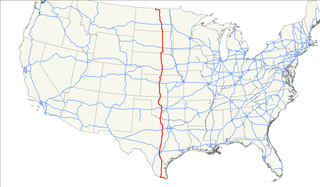
U.S. Route 81 or U.S. Highway 81 (US 81) is a major north–south U.S. highway that extends for 1,220 miles (1,960 km) in the central United States and is one of the original United States Numbered Highways established in 1926 by the American Association of State Highway Officials.
U.S. Route 281 (US 281) is a north–south United States Numbered Highway. At 1,875 miles (3,018 km) long it is the longest continuous three-digit U.S. Route.

U.S. Route 83 (US 83) is a major north–south United States Numbered Highway that extends 1,885 miles (3,034 km) in the central United States. Only four other north–south routes are longer: US 1, US 41, US 59, and US 87. The highway's northern terminus is north of Westhope, North Dakota, at the Canadian border, where it continues as Manitoba Highway 83. The southern terminus is at the Veterans International Bridge in Brownsville, Texas. Together, US 83 and PTH 83 form a continuously numbered north-south highway with a combined distance is 3,450 kilometres.
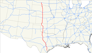
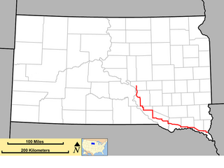
U.S. Route 183 (US 183) is a north–south United States highway. The highway's northern terminus is in Presho, South Dakota, at an intersection with Interstate 90. Its southern terminus is in Refugio, Texas, at the southern intersection of U.S. Highway 77 and Alternate US 77.

U.S. Route 34 (US 34) is an east–west United States highway that runs for 1,122 miles (1,806 km) from north-central Colorado to the western suburbs of Chicago. Through Rocky Mountain National Park it is known as the Trail Ridge Road where it reaches elevation 12,183 feet (3,713 m), making it the third highest paved through highway in the United States. The highway's western terminus is Granby, Colorado at US 40. Its eastern terminus is in Berwyn, Illinois at Illinois Route 43 and Historic US 66.

South Dakota Highway 44 (SD 44) is a state highway in southern South Dakota that runs from U.S. Route 385 (US 385) west of Rapid City to Interstate 29 (I-29) south of Sioux Falls. It is just more than 379 miles (610 km) long.
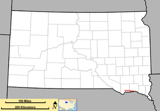
South Dakota Highway 43 (SD 43) is a 1.131-mile-long (1.820 km) state highway that exists entirely in the southern part of Gregory County in the southern part of the U.S. state of South Dakota. It begins as an extension of Nebraska Highway 11 (N-11) at the Nebraska state line south of Fairfax. It travels northwest to an intersection with U.S. Route 18 (US 18) south-southwest of the town.

South Dakota Highway 47 is a state route that runs north to south across the central portion of South Dakota. It begins at an unnumbered highway at the North Dakota border north of Eureka, and ends at the Nebraska border, where it becomes Nebraska Highway 137. It is just under 241 miles (388 km) in length.

South Dakota Highway 22 (SD 22) is a 48.546-mile-long (78.127 km) state highway in Hamlin and Deuel counties in South Dakota, United States. It connects Hazel and Clear Lake.
South Dakota Highway 52 is a state route that runs just north of the Missouri River, across southeast South Dakota. It begins at a junction with South Dakota Highway 37 north of Springfield, and terminates in Yankton at U.S. Highway 81, at the junction of 4th and Broadway Streets. It is 37 miles (60 km) in length.

South Dakota Highway 53 is a state route that runs north to south across south central South Dakota. It consists of two separate segments:

South Dakota Highway 15 (SD 15) is a 67.562-mile-long (108.730 km) state highway in the northeastern South Dakota, United States. It connects Clear Lake, Milbank, and Wilmot.
South Dakota Highway 50 is a state route serving south central and southeast South Dakota. The current alignment begins at the junction of South Dakota Highway 34 at "Lee's Corner" east of Fort Thompson, and ends at the Iowa border near Richland, where it continues as Iowa Highway 3. It is about 212 miles (341 km) in length.
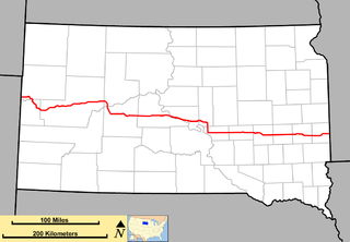
South Dakota Highway 34 is a state route that runs parallel to Interstate 90 across the entire state of South Dakota. It begins at the Wyoming border west of Belle Fourche, as a continuation of Wyoming Highway 24 (WYO 24). The eastern terminus is at the Minnesota border east of Egan, or southwest of Airlie, Minnesota, where it continues as Minnesota State Highway 30 (MN 30). It is just over 419 miles (674 km) in length.

South Dakota Highway 19 (SD 19) is a 86.974-mile (139.971 km) state highway in southeastern South Dakota, United States. It connects the Nebraska state line, south of Vermillion, with the southeastern part of the Madison area, via Viborg, Hurley, Parker, and Humboldt. SD 19 formerly entered Centerville, but was shifted to the south. Its former path was redesignated as SD 19A. Its former southern terminus was at Vermillion, but was extended when a new bridge from Nebraska opened.

South Dakota Highway 73 is a state route that runs across western South Dakota. It begins at the Nebraska border north of Merriman, Nebraska, as a continuation of Nebraska Highway 61. It runs to the North Dakota border, where it continues as North Dakota Highway 49. It is just more than 255 miles (410 km) in length.

South Dakota Highway 11 (SD 11) is a 77.724-mile (125.085 km) state highway in eastern South Dakota, United States. It connects the northern part of the Sioux City metropolitan area with the Sioux Falls metropolitan area.

South Dakota Highway 42 (SD 42) is a segmented state highway in southeastern South Dakota, United States. The first segment is a six-mile-long (9.7 km) highway in Aurora County. The second and longest is 60 miles (97 km) long and connects Ethan and Sioux Falls. The final segment connects Sioux Falls to Iowa Highway 9 southeast of Rowena.

South Dakota Highway 40 (SD 40) is a state highway in southwest South Dakota, United States. The highway is just over 37 miles (60 km) long and runs from U.S. Route 16A (US 16A) in Keystone to Bureau of Indian Affairs Highway 41 in Red Shirt. The highway runs near Mount Rushmore National Memorial in Keystone, and its eastern terminus is on the Pine Ridge Indian Reservation near the edge of Badlands National Park.

