Leola, South Dakota | |
---|---|
Coordinates: 45°43′16″N98°56′19″W / 45.72111°N 98.93861°W | |
Country | United States |
State | South Dakota |
County | McPherson |
Incorporated | 1919 [1] |
Government | |
• Type | Mayor-council |
• Mayor | Royce Erdmann [ citation needed ] |
Area | |
• Total | 0.75 sq mi (1.93 km2) |
• Land | 0.74 sq mi (1.92 km2) |
• Water | 0.004 sq mi (0.01 km2) |
Elevation | 1,591 ft (485 m) |
Population | |
• Total | 434 |
• Density | 584.91/sq mi (225.87/km2) |
Time zone | UTC-6 (Central (CST)) |
• Summer (DST) | UTC-5 (CDT) |
ZIP code | 57456 |
Area code | 605 |
FIPS code | 46-36460 |
GNIS feature ID | 1267460 [3] |
Website | www |
Leola is a small city in, and the county seat of, McPherson County, South Dakota, United States. It was founded on May 1, 1884, and named for Leola Haynes, [5] daughter of one of the town's founders. The population was 434 as of the 2020 census. [6]
The city occupies an entirely rural area, and businesses and services include a grocery store a gas station-garage, restaurants and bars, a bank, a post office, a hotel, several small businesses (including farming supplies and equipment) and shops, grain elevators, local police and fire departments, and the county's public schools. The city is administered by a mayor-council form of government.
According to the United States Census Bureau, the city has a total area of 0.73 square miles (1.89 km2), of which 0.72 square miles (1.86 km2) is land and 0.01 square miles (0.03 km2) is water. [7]
Census | Pop. | Note | %± |
---|---|---|---|
1910 | 484 | — | |
1920 | 637 | 31.6% | |
1930 | 724 | 13.7% | |
1940 | 795 | 9.8% | |
1950 | 772 | −2.9% | |
1960 | 833 | 7.9% | |
1970 | 787 | −5.5% | |
1980 | 645 | −18.0% | |
1990 | 521 | −19.2% | |
2000 | 462 | −11.3% | |
2010 | 457 | −1.1% | |
2020 | 434 | −5.0% | |
U.S. Decennial Census [8] 2018 Estimate [9] [4] |
As of the census [10] of 2010, there were 457 people, 209 households, and 125 families residing in the city. The population density was 634.7 inhabitants per square mile (245.1/km2). There were 258 housing units at an average density of 358.3 per square mile (138.3/km2). The racial makeup of the city was 96.3% White, 0.2% African American, 0.2% Native American, 0.2% Asian, and 3.1% from two or more races. Hispanic or Latino of any race were 2.0% of the population.
There were 209 households, of which 25.4% had children under the age of 18 living with them, 50.7% were married couples living together, 5.7% had a female householder with no husband present, 3.3% had a male householder with no wife present, and 40.2% were non-families. 36.8% of all households were made up of individuals, and 16.7% had someone living alone who was 65 years of age or older. The average household size was 2.19 and the average family size was 2.88.
The median age in the city was 43.1 years. 23.4% of residents were under the age of 18; 5.6% were between the ages of 18 and 24; 22.7% were from 25 to 44; 25.8% were from 45 to 64; and 22.5% were 65 years of age or older. The gender makeup of the city was 50.8% male and 49.2% female.
As of the census of 2000, there were 462 people, 234 households, and 135 families residing in the city. The population density was 651.2 inhabitants per square mile (251.4/km2). There were 268 housing units at an average density of 377.7 per square mile (145.8/km2). The racial makeup of the city was 99.78% White and 0.22% Native American.
There were 234 households, out of which 18.8% had children under the age of 18 living with them, 51.3% were married couples living together, 3.0% had a female householder with no husband present, and 42.3% were non-families. 40.6% of all households were made up of individuals, and 21.4% had someone living alone who was 65 years of age or older. The average household size was 1.97 and the average family size was 2.64.
In the city, the population was spread out, with 18.6% under the age of 18, 4.8% from 18 to 24, 22.5% from 25 to 44, 23.2% from 45 to 64, and 31.0% who were 65 years of age or older. The median age was 48 years. For every 100 females, there were 93.3 males. For every 100 females age 18 and over, there were 88.0 males.
The median income for a household in the city was $24,559, and the median income for a family was $33,125. Males had a median income of $28,250 versus $22,321 for females. The per capita income for the city was $15,807. About 1.5% of families and 10.8% of the population were below the poverty line, including 9.4% of those under age 18 and 16.2% of those age 65 or over.
Leola School District is located in Leola, and it is a K-12 school district. This growing public school serves as the hub of many community based activities. [11]
McPherson County is a county in the U.S. state of South Dakota. As of the 2020 census, the population was 2,411. Its county seat is Leola.
White is a city in Brookings County, South Dakota, United States. The population was 537 at the 2020 census.
Wagner is a city in Charles Mix County, South Dakota, United States. The population was 1,490 at the 2020 census. The city is served by Wagner Municipal Airport as well as YST Transit buses.
Willow Lake is a city in Clark County, South Dakota, United States. The population was 255 at the 2020 census.
Ipswich is a city in and county seat of Edmunds County, South Dakota, United States. The population was 928 at the 2020 census.
Gregory is a city in western Gregory County, South Dakota, United States. The population was 1,221 at the 2020 census.
Miller is a city in and county seat of Hand County, South Dakota, United States. The population was 1,349 at the 2020 census.
Kadoka is a city in, and the county seat of, Jackson County, South Dakota, United States. The population was 543 at the 2020 census. The town occupies about 2.3 square miles.
Wentworth is an incorporated village in Lake County, South Dakota, United States. It is the only incorporated village in the state of South Dakota. The population was 181 at the 2020 census.
Tea is a city in Lincoln County, South Dakota, United States and is a suburb of Sioux Falls. The population was 5,598 at the 2020 census.
Presho is a small city in Lyman County, South Dakota, United States. The population was 472 at the 2020 census.
Baltic is a city on the Big Sioux River in northern Minnehaha County, South Dakota, United States. The population was 1,246 at the 2020 census.
Crooks is a city in Minnehaha County, South Dakota, United States and is a suburb of Sioux Falls. The population was 1,362 at the 2020 census. Crooks was named New Hope until 1904. The town's present name honors W. A. Crooks, a local politician.
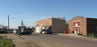
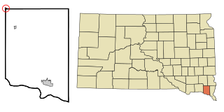
Ashton is a city in eastern Spink County, South Dakota, United States. The population was 108 at the 2020 census.
Mellette is a city in Spink County, South Dakota, United States. The population was 199 at the 2020 census.
Viborg is a city in Turner County, South Dakota, United States. The population was 814 at the 2020 census.
Elk Point is a city in and county seat of Union County, South Dakota, United States. The population was 2,149 as of the 2020 census.
Leola is a town in Adams County in the U.S. state of Wisconsin. The population was 308 at the 2010 census.
Iroquois is a city on the border of Beadle and Kingsbury counties in South Dakota, United States. The population was 292 at the 2020 census. The school building is located in Kingsbury County, while the school parking lot is located in Beadle County. Highway 14 runs directly through Iroquois.
Irene is a city in Clay, Turner, and Yankton counties in South Dakota, United States. The population was 422 at the 2020 census. The portion of Irene that is located in Turner County is a part of the Sioux Falls, South Dakota metropolitan area, the portion located in Yankton County is part of the Yankton Micropolitan Statistical Area, and the portion located in Clay County is part of both the Vermillion Micropolitan Statistical Area and the Sioux City-Vermillion Combined Statistical Area. Irene is also host to the Irene Rodeo, held every summer.