Buffalo, South Dakota

Last updated

Buffalo, South Dakota
Harding County Courthouse.JPG
Harding County Courthouse in Buffalo
Harding County South Dakota Incorporated and Unincorporated areas Buffalo Highlighted.svg
Location in Harding County and the state of South Dakota
Coordinates: 45°35′11″N103°32′36″W / 45.58639°N 103.54333°W / 45.58639; -103.54333
Country United States
State South Dakota
County Harding
Incorporated1949 [1]
Area
[2]
  Total0.55 sq mi (1.43 km2)
  Land0.55 sq mi (1.43 km2)
  Water0.00 sq mi (0.00 km2)
Elevation
[3]
2,897 ft (883 m)
Population
 (2020) [4]
  Total346
  Density624.55/sq mi (241.29/km2)
Time zone UTC-7 (Mountain (MST))
  Summer (DST) UTC-6 (MDT)
ZIP code
57720
Area code 605
FIPS code 46-08140 [5]
GNIS feature ID1267302 [3]
Website townofbuffalo.municipalimpact.com

Buffalo is a town in, and the county seat of, Harding County, South Dakota, United States. The population was 346 at the 2020 census. [6]

Contents

History

Buffalo was established in 1909. [7] It was named for the large herds of bison (mistakenly called buffalo) that once roamed the area. [8] It is about fifty miles west of Bison, South Dakota.

Geography

According to the United States Census Bureau, the town has a total area of 0.55 square miles (1.42 km2), all land. [9]

Climate

Buffalo has a cold semi-arid climate (Köppen BSk). Like all of the High Plains, this climate features summers with cool to pleasant mornings and typically very warm to hot afternoons, alongside winters that average freezing but are extremely variable due to the conflict between hot Chinook winds and cold Arctic air. Annual precipitation is quite low at around 14.5 inches or 370 millimetres and concentrated in the spring and summer months from April to August. Buffalo lies within USDA hardiness zone 4a, meaning temperatures can drop to as low as −30 to −25 °F (−34.4 to −31.7 °C). [10]

Climate data for Buffalo, South Dakota (2,881 feet above sea level)
MonthJanFebMarAprMayJunJulAugSepOctNovDecYear
Record high °F (°C)69.0
(20.6)
72.0
(22.2)
82.0
(27.8)
94.0
(34.4)
101.0
(38.3)
108.0
(42.2)
113.0
(45.0)
114.0
(45.6)
105.0
(40.6)
95.0
(35.0)
84.0
(28.9)
70.0
(21.1)
114.0
(45.6)
Mean daily maximum °F (°C)33.0
(0.6)
37.0
(2.8)
47.0
(8.3)
59.0
(15.0)
68.0
(20.0)
78.0
(25.6)
87.0
(30.6)
87.0
(30.6)
76.0
(24.4)
61.0
(16.1)
45.0
(7.2)
34.0
(1.1)
59.3
(15.2)
Daily mean °F (°C)21.5
(−5.8)
25.0
(−3.9)
34.0
(1.1)
44.5
(6.9)
54.5
(12.5)
64.0
(17.8)
71.0
(21.7)
70.0
(21.1)
59.5
(15.3)
46.5
(8.1)
32.5
(0.3)
22.5
(−5.3)
45.5
(7.5)
Mean daily minimum °F (°C)10.0
(−12.2)
13.0
(−10.6)
21.0
(−6.1)
30.0
(−1.1)
41.0
(5.0)
50.0
(10.0)
55.0
(12.8)
53.0
(11.7)
43.0
(6.1)
32.0
(0.0)
20.0
(−6.7)
11.0
(−11.7)
31.6
(−0.2)
Record low °F (°C)−57.0
(−49.4)
−50.0
(−45.6)
−33.0
(−36.1)
−12.0
(−24.4)
4.0
(−15.6)
24.0
(−4.4)
32.0
(0.0)
27.0
(−2.8)
9.0
(−12.8)
−17.0
(−27.2)
−28.0
(−33.3)
−46.0
(−43.3)
−57.0
(−49.4)
Average precipitation inches (mm)0.31
(7.9)
0.31
(7.9)
0.71
(18)
1.38
(35)
2.54
(65)
2.69
(68)
2.13
(54)
1.38
(35)
1.21
(31)
1.14
(29)
0.50
(13)
0.29
(7.4)
14.59
(371.2)
Source: Weather Channel [11]

Demographics

Historical population
CensusPop.Note
1950 380
1960 65271.6%
1970 393−39.7%
1980 45315.3%
1990 4887.7%
2000 380−22.1%
2010 330−13.2%
2020 3464.8%
U.S. Decennial Census [12] [4]

2010 census

As of the census [13] of 2010, there were 330 people, 168 households, and 86 families residing in the town. The population density was 600.0 inhabitants per square mile (231.7/km2). There were 220 housing units at an average density of 400.0 per square mile (154.4/km2). The racial makeup of the town was 97.3% White, 0.9% Native American, 0.3% from other races, and 1.5% from two or more races. Hispanic or Latino of any race were 1.5% of the population.

There were 168 households, of which 22.0% had children under the age of 18 living with them, 41.7% were married couples living together, 7.1% had a female householder with no husband present, 2.4% had a male householder with no wife present, and 48.8% were non-families. 46.4% of all households were made up of individuals, and 19.6% had someone living alone who was 65 years of age or older. The average household size was 1.96 and the average family size was 2.80.

The median age in the town was 43.8 years. 21.2% of residents were under the age of 18; 5.8% were between the ages of 18 and 24; 24.6% were from 25 to 44; 30.6% were from 45 to 64; and 17.9% were 65 years of age or older. The gender makeup of the town was 52.7% male and 47.3% female.

See also

Related Research Articles

<span class="mw-page-title-main">Pierre, South Dakota</span> Capital city of South Dakota, United States

Pierre is the capital city of the U.S. state of South Dakota and the County seat of Hughes County. The population was 14,091 at the 2020 census, making it the 2nd least populous US state capital after Montpelier, Vermont. It is South Dakota's 9th most populous city. Pierre is the principal city of the Pierre Micropolitan Statistical Area, which includes all of Hughes and Stanley counties.

<span class="mw-page-title-main">Perkins County, South Dakota</span> County in South Dakota, United States

Perkins County is a county in the U.S. state of South Dakota. As of the 2020 census, the population was 2,835. Its county seat is Bison. The county was established in 1908 and organized in 1909. It was named for Sturgis, South Dakota, official Henry E. Perkins.

<span class="mw-page-title-main">Buffalo County, South Dakota</span> County in South Dakota, United States

Buffalo County is a county in the U.S. state of South Dakota. As of the 2020 census, the population was 1,948. Its county seat is Gann Valley which, at 10 people, is the least populous county seat in the United States. The county was created in 1864, and was organized in 1871 as part of the Dakota Territory.

<span class="mw-page-title-main">Huron, South Dakota</span> City in the United States

Huron is a city in and the county seat of Beadle County, South Dakota, United States. The population was 14,263 at the 2020 census, and it is the 8th most populous city in South Dakota.

<span class="mw-page-title-main">Martin, South Dakota</span> City in South Dakota, United States

Martin is a city and the county seat of Bennett County, South Dakota, United States. The population was 938 at the 2020 census.

<span class="mw-page-title-main">McLaughlin, South Dakota</span> City in South Dakota, United States

McLaughlin is a city in northeastern Corson County, South Dakota, United States. The population was 663 at the 2010 census. It is the largest city on the Standing Rock Indian Reservation. Most Lakȟóta speakers refer to the town as Makáȟleča or Matȟó Akíčita.

<span class="mw-page-title-main">Fairburn, South Dakota</span> Town in South Dakota, United States

Fairburn is a town in Custer County, South Dakota, United States. The population was 60 at the 2020 census.

<span class="mw-page-title-main">Pierpont, South Dakota</span> Town in South Dakota, United States

Pierpont is a town in northwestern Day County, South Dakota, United States. The population was 129 at the 2020 census.

<span class="mw-page-title-main">Webster, South Dakota</span> City in South Dakota, United States

Webster is a city in and the county seat of Day County, South Dakota, United States. The population was 1,728 at the 2020 census.

<span class="mw-page-title-main">Philip, South Dakota</span> City in South Dakota, United States

Philip is a city in and the county seat of rural Haakon County, South Dakota, United States. The population was 759 at the 2020 census.

<span class="mw-page-title-main">Castlewood, South Dakota</span> Town in South Dakota, United States

Castlewood is a city in Hamlin County, South Dakota, United States. It is part of the Watertown, South Dakota Micropolitan Statistical Area. The population was 698 at the 2020 census. and was estimated to be 707 in 2022.

<span class="mw-page-title-main">Hayti, South Dakota</span> Town in South Dakota, United States

Hayti is a town in and county seat of Hamlin County, South Dakota, United States. The population was 393 at the 2020 census. It is part of the Watertown, South Dakota Micropolitan Statistical Area. It is the county seat of Hamlin County.

<span class="mw-page-title-main">Ree Heights, South Dakota</span> Town in South Dakota, United States

Ree Heights is a town in western Hand County, South Dakota, United States. The population was 62 at the 2010 census.

<span class="mw-page-title-main">Camp Crook, South Dakota</span> Town in South Dakota, United States

Camp Crook is an incorporated small town in Harding County, South Dakota, United States, on the Little Missouri River. The population was 60 at the 2020 census.

<span class="mw-page-title-main">Alpena, South Dakota</span> Town in South Dakota, United States

Alpena is a town in northeastern corner of Jerauld County, South Dakota, United States. The population was 286 at the 2010 census.

<span class="mw-page-title-main">Sturgis, South Dakota</span> City in South Dakota, United States

Sturgis is a city in Meade County, South Dakota, United States. The population was 7,020 as of the 2020 census. It is the county seat of Meade County and is named after Samuel D. Sturgis, a Union general during the Civil War.

<span class="mw-page-title-main">Bison, South Dakota</span> Town in South Dakota, United States

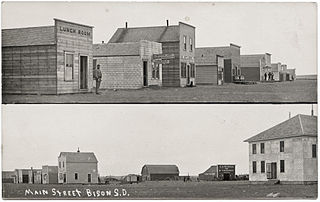
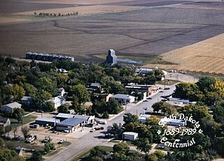
Bison is a town in and the county seat of Perkins County, South Dakota, United States. The population was 302 at the 2020 census.

<span class="mw-page-title-main">Gettysburg, South Dakota</span> City in South Dakota, United States

Gettysburg is a city and county seat of Potter County, South Dakota, United States, along the 45th parallel. The population was 1,104 at the 2020 census.

<span class="mw-page-title-main">New Effington, South Dakota</span> Town in South Dakota, United States

New Effington is a town in Roberts County, South Dakota, United States. The population was 234 at the 2020 census.

<span class="mw-page-title-main">Dupree, South Dakota</span> City in South Dakota, United States

Dupree is a city in and county seat of Ziebach County, South Dakota, United States. The population was 494 at the 2020 census. It is the only incorporated community located fully within Ziebach County.

References

  1. "SD Towns" (PDF). South Dakota State Historical Society. Archived from the original (PDF) on February 10, 2010. Retrieved February 11, 2010.
  2. "ArcGIS REST Services Directory". United States Census Bureau. Retrieved October 15, 2022.
  3. 1 2 U.S. Geological Survey Geographic Names Information System: Buffalo, South Dakota
  4. 1 2 "Census Population API". United States Census Bureau. Retrieved October 15, 2022.
  5. "U.S. Census website". United States Census Bureau . Retrieved January 31, 2008.
  6. "Buffalo town, South Dakota". U.S. Census Bureau. United States Census Bureau. Archived from the original on January 28, 2023. Retrieved May 28, 2022.
  7. Hellmann, Paul T. (May 13, 2013). Historical Gazetteer of the United States. Routledge. p. 984. ISBN   978-1135948597 . Retrieved November 30, 2013.
  8. Federal Writers' Project (1940). South Dakota place-names, v.1-3. University of South Dakota. p. 28.
  9. "US Gazetteer files 2010". United States Census Bureau. Archived from the original on January 25, 2012. Retrieved June 21, 2012.
  10. "USDA Plant Hardiness Zone Map". United States Department of Agriculture. Archived from the original on February 27, 2014. Retrieved July 12, 2018.
  11. "Buffalo, SD Monthly Weather Forecast". Weather Channel . Retrieved August 5, 2018.
  12. United States Census Bureau. "Census of Population and Housing" . Retrieved November 8, 2014.
  13. "U.S. Census website". United States Census Bureau . Retrieved June 21, 2012.