Armour, South Dakota

Last updated

Armour, South Dakota
Armour, South Dakota, E side Main St S of 2nd St.jpg
Downtown Armour: Main Street
Douglas County South Dakota Incorporated and Unincorporated areas Armour Highlighted.svg
Location in Douglas County and the state of South Dakota
Coordinates: 43°19′08″N98°20′41″W / 43.31889°N 98.34472°W / 43.31889; -98.34472
Country United States
State South Dakota
County Douglas
Incorporated1904 [1]
Area
[2]
  Total0.95 sq mi (2.47 km2)
  Land0.94 sq mi (2.45 km2)
  Water0.01 sq mi (0.02 km2)
Elevation
[3]
1,519 ft (463 m)
Population
 (2020) [4]
  Total698
  Density739.41/sq mi (285.36/km2)
Time zone UTC-6 (Central (CST))
  Summer (DST) UTC-5 (CDT)
ZIP code
57313
Area code 605
FIPS code 46-02260 [5]
GNIS feature ID1267268 [3]
Website www.armoursd.com

Armour is a city in county seat of Douglas County, South Dakota, United States. [6] The population was 698 at the 2020 census. [7]

Contents

History

Armour was founded in 1885. The city was named after Philip Danforth Armour, who was the founder of Armour and Company, a meat packing company. [8] Contrary to popular belief, Armour was never home to a meat packing plant; the town was so named because Mr. Armour was also the chairman of the railroad that went through Armour and donated a bell to the local congregational church. The athletic teams of Armour High School were formerly known as the "Packers" in reference to the well known packing company, although today the high school plays its sports jointly with Tripp-Delmont High School as the "Armour/Tripp-DelmontNighthawks." [9]

Geography

According to the United States Census Bureau, the city has a total area of 0.95 square miles (2.46 km2), of which 0.94 square miles (2.43 km2) is land and 0.01 square miles (0.03 km2) is water. [10]

Demographics

Historical population
CensusPop.Note
1890 482
1900 91289.2%
1910 9686.1%
1920 1,0458.0%
1930 1,009−3.4%
1940 1,0130.4%
1950 900−11.2%
1960 875−2.8%
1970 9255.7%
1980 819−11.5%
1990 8544.3%
2000 782−8.4%
2010 699−10.6%
2020 698−0.1%
[4]

2010 census

As of the census [11] of 2010, there were 699 people, 325 households, and 181 families residing in the city. The population density was 743.6 inhabitants per square mile (287.1/km2). There were 378 housing units at an average density of 402.1 per square mile (155.3/km2). The racial makeup of the city was 95.7% White, 2.7% Native American, 0.3% Asian, and 1.3% from two or more races. Hispanic or Latino of any race were 0.6% of the population.

There were 325 households, of which 20.6% had children under the age of 18 living with them, 49.5% were married couples living together, 3.7% had a female householder with no husband present, 2.5% had a male householder with no wife present, and 44.3% were non-families. 41.5% of all households were made up of individuals, and 28% had someone living alone who was 65 years of age or older. The average household size was 2.02 and the average family size was 2.72.

The median age in the city was 52.4 years. 18.5% of residents were under the age of 18; 4% were between the ages of 18 and 24; 15.5% were from 25 to 44; 28.2% were from 45 to 64; and 33.8% were 65 years of age or older. The gender makeup of the city was 46.1% male and 53.9% female.

The Douglas County Courthouse in Armour 1995 Douglas County Courthouse Armour.jpg
The Douglas County Courthouse in Armour 1995

2000 census

As of the census [5] of 2000, there were 782 people, 342 households, and 215 families residing in the city. The population density was 828.9 inhabitants per square mile (320.0/km2). There were 377 housing units at an average density of 399.6 per square mile (154.3/km2). The racial makeup of the city was 98.08% White, 0.77% Native American, 0.13% from other races, and 1.02% from two or more races. Hispanic or Latino of any race were 0.64% of the population.

There were 342 households, out of which 26.3% had children under the age of 18 living with them, 56.4% were married couples living together, 5.0% had a female householder with no husband present, and 37.1% were non-families. 35.7% of all households were made up of individuals, and 21.3% had someone living alone who was 65 years of age or older. The average household size was 2.16 and the average family size was 2.79.

In the city, the population was spread out, with 22.0% under the age of 18, 3.6% from 18 to 24, 21.4% from 25 to 44, 22.4% from 45 to 64, and 30.7% who were 65 years of age or older. The median age was 48 years. For every 100 females, there were 87.1 males. For every 100 females age 18 and over, there were 79.4 males.

The median income for a household in the city was $28,438, and the median income for a family was $41,797. Males had a median income of $27,500 versus $18,897 for females. The per capita income for the city was $15,829. About 8.8% of families and 12.6% of the population were below the poverty line, including 18.4% of those under age 18 and 12.4% of those age 65 or over.

Climate

This climatic region is typified by large seasonal temperature differences, with warm to hot (and often humid) summers and cold (sometimes severely cold) winters. According to the Köppen Climate Classification system, Armour has a humid continental climate, abbreviated "Dfa" on climate maps. [12]

Climate data for Armour, South Dakota
MonthJanFebMarAprMayJunJulAugSepOctNovDecYear
Mean daily maximum °C (°F)−1
(30)
2
(35)
8
(46)
17
(62)
23
(73)
28
(83)
32
(90)
31
(88)
26
(78)
19
(66)
8
(47)
1
(34)
16
(61)
Mean daily minimum °C (°F)−14
(7)
−11
(12)
−6
(22)
2
(35)
8
(47)
14
(57)
17
(62)
16
(60)
10
(50)
3
(38)
−4
(24)
−11
(13)
2
(35)
Average precipitation mm (inches)15
(0.6)
18
(0.7)
36
(1.4)
61
(2.4)
81
(3.2)
99
(3.9)
71
(2.8)
71
(2.8)
56
(2.2)
38
(1.5)
23
(0.9)
15
(0.6)
580
(23)
Source: Weatherbase [13]

Notable people

See also

Related Research Articles

<span class="mw-page-title-main">Douglas County, South Dakota</span> County in South Dakota, United States

Douglas County is a county in the U.S. state of South Dakota. As of the 2020 census, the population was 2,835. Its county seat is Armour. The county was established in 1873 and organized in 1882. It is named for Stephen Douglas, Illinois political figure.

<span class="mw-page-title-main">South St. Paul, Minnesota</span> City in Minnesota, United States

South St. Paul is a city in Dakota County, Minnesota, United States, immediately south and southeast of St. Paul and east of West St. Paul. The population was 20,759 at the 2020 census. The town was a major meat-packing location, and many residents are descended from immigrants of Southern European and Eastern European heritage, who came to work in the meat-packing plants in the early twentieth century.

<span class="mw-page-title-main">Groton, South Dakota</span> City in South Dakota, United States

Groton is a city in southeastern Brown County, South Dakota, United States. The population was 1,380 at the 2020 census.

<span class="mw-page-title-main">Marty, South Dakota</span> CDP in South Dakota, United States

Marty is a census-designated place (CDP) in southern Charles Mix County, South Dakota, United States. The population was 677 at the 2020 census.

<span class="mw-page-title-main">Wagner, South Dakota</span> City in South Dakota, United States

Wagner is a city in Charles Mix County, South Dakota, United States. The population was 1,490 at the 2020 census. The city is served by Wagner Municipal Airport as well as YST Transit buses.

<span class="mw-page-title-main">Clear Lake, South Dakota</span> City in South Dakota, United States

Clear Lake is a city in and the county seat of Deuel County, South Dakota, United States. The population was 1,218 at the 2020 census.

<span class="mw-page-title-main">Delmont, South Dakota</span> City in South Dakota, United States

Delmont is a city in southeastern Douglas County, South Dakota, United States. The population was 153 at the 2020 census.

<span class="mw-page-title-main">Milbank, South Dakota</span> City in South Dakota, United States

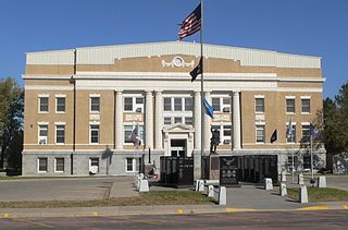
Milbank is a city in Grant County, South Dakota, United States, located along the South Fork of the Whetstone River. The population was 3,544 at the 2020 census. It is the county seat of Grant County. Milbank is the birthplace of American Legion Baseball. The program was created in Milbank in 1925 and is now enjoyed by high school aged youth on more than five thousand teams in all fifty states.

<span class="mw-page-title-main">Parkston, South Dakota</span> City in South Dakota, United States

Parkston is a city in Hutchinson County, South Dakota, United States. The population was 1,567 at the 2020 census.

<span class="mw-page-title-main">Tripp, South Dakota</span> City in South Dakota, United States

Tripp is a city in Hutchinson County, South Dakota, United States. The population was 575 in the 2020 census.

<span class="mw-page-title-main">Kadoka, South Dakota</span> City in South Dakota, United States

Kadoka is a city in, and the county seat of, Jackson County, South Dakota, United States. The population was 543 at the 2020 census. The town occupies about 2.3 square miles.

<span class="mw-page-title-main">Presho, South Dakota</span> City in South Dakota, United States

Presho is a small city in Lyman County, South Dakota, United States. The population was 472 at the 2020 census.

<span class="mw-page-title-main">Leola, South Dakota</span> City in South Dakota, United States

Leola is a small city in, and the county seat of, McPherson County, South Dakota, United States. It was founded on May 1, 1884, and named for Leola Haynes, daughter of one of the town's founders. The population was 434 as of the 2020 census.

<span class="mw-page-title-main">Crooks, South Dakota</span> City in South Dakota, United States

Crooks is a city in Minnehaha County, South Dakota, United States and is a suburb of Sioux Falls. The population was 1,362 at the 2020 census. Crooks was named New Hope until 1904. The town's present name honors W. A. Crooks, a local politician.

<span class="mw-page-title-main">Garretson, South Dakota</span> City in South Dakota, United States

Garretson is a city in Minnehaha County, South Dakota, United States. The city had a population of 1,228 at the 2020 census.

<span class="mw-page-title-main">Hartford, South Dakota</span> City in South Dakota, United States

Hartford is a suburban American city in Minnehaha County, South Dakota, a few miles northwest of Sioux Falls. Its population was 3,354 at the 2020 census.

<span class="mw-page-title-main">Colome, South Dakota</span> City in South Dakota, United States

Colome is a city in Tripp County, South Dakota, United States. The population was 331 as of the 2020 census.

<span class="mw-page-title-main">Hamill, South Dakota</span> CDP in South Dakota, United States

Hamill is a rural hamlet in Tripp County, South Dakota, United States. The population was 14 at the 2020 census. There is a post office at Hamill, also two churches and a community hall; otherwise, no businesses or services.

<span class="mw-page-title-main">New Witten, South Dakota</span> Town in South Dakota, United States

New Witten is a town in Tripp County, South Dakota, United States. The population was 54 at the 2020 census.

<span class="mw-page-title-main">Winner, South Dakota</span> City in South Dakota, United States

Winner is a city in central Tripp County, South Dakota, United States. The population was 2,921 at the 2020 census. It is the county seat of Tripp County. Winner also serves as the administrative center of neighboring Todd County, which does not have its own county seat. The nearest airport is Winner Regional Airport.

References

  1. "SD Towns" (PDF). South Dakota State Historical Society. Archived from the original (PDF) on February 10, 2010. Retrieved February 10, 2010.
  2. "ArcGIS REST Services Directory". United States Census Bureau. Retrieved October 15, 2022.
  3. 1 2 U.S. Geological Survey Geographic Names Information System: Armour, South Dakota
  4. 1 2 "Census Population API". United States Census Bureau. Retrieved October 15, 2022.
  5. 1 2 "U.S. Census website". United States Census Bureau . Retrieved January 31, 2008.
  6. "Find a County". National Association of Counties. Archived from the original on May 31, 2011. Retrieved June 7, 2011.
  7. "U.S. Census Bureau: Armour city, South Dakota". www.census.gov. United States Census Bureau. Retrieved December 23, 2021.
  8. Federal Writers' Project (1940). South Dakota place-names, v.1-3. University of South Dakota. p. 23.
  9. "Tripp Delmont Armour Nighthawks". Archived from the original on July 18, 2011. Retrieved February 26, 2008.
  10. "US Gazetteer files 2010". United States Census Bureau. Archived from the original on January 25, 2012. Retrieved June 21, 2012.
  11. "U.S. Census website". United States Census Bureau . Retrieved June 21, 2012.
  12. Climate Summary for Armour, South Dakota
  13. "Weatherbase.com". Weatherbase. 2013. Retrieved on October 13, 2013.