Hingham is a town in metropolitan Greater Boston on the South Shore of the U.S. state of Massachusetts in northern Plymouth County. At the 2010 census, the population was 22,157. Hingham is known for its colonial history and location on Boston Harbor. The town was named after Hingham, Norfolk, England, and was first settled by English colonists in 1633.

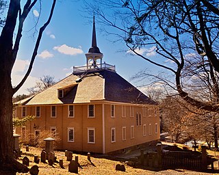
The Old Ship Church is a Puritan church built in 1681 in Hingham, Massachusetts. It is the only surviving 17th-century Puritan meetinghouse in America. Its congregation, gathered in 1635 and officially known as First Parish in Hingham, occupies the oldest church building in continuous ecclesiastical use in the United States. On October 9, 1960, it was designated a National Historic Landmark and on November 15, 1966, it was added to the National Register of Historic Places.

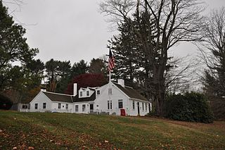
The General Benjamin Lincoln House is a National Historic Landmark at 181 North Street in Hingham, Massachusetts, United States. It was the birthplace and principal residence of Continental Army Major General Benjamin Lincoln (1733–1810), a well-respected military leader of the American Revolutionary War. The house has portions that are said to date to the 1630s, with significant additions made principally during the 18th century, possibly making it one of the nation's oldest wood frame buildings. The last major modifications to the house were probably undertaken by General Lincoln in the late 18th century.

The South Glastonbury Historic District is a historic district in Glastonbury, Connecticut. It encompasses the historic village center of South Glastonbury, which was first settled in the 17th century. The district was listed on the National Register of Historic Places in 1984, and enlarged in 2009 to include properties further along Main Street as far as Chestnut Hill Road. Locals refer to it as Nayaug.

Downtown Fall River Historic District is a historic district on North and South Main, Bedford, Granite, Bank, Franklin, and Elm Streets in Fall River, Massachusetts.

The St. Charles Borromeo Church is a historic Catholic church building in Waltham, Massachusetts. Built in 1922, it is a high quality example of Italian Renaissance Revival architecture, and is emblematic of the shift on Waltham's south side from a predominantly Protestant population to one of greater diversity. The building was listed on the National Register of Historic Places in 1989.

The Caleb Cushing House and Farm is a historic farm property at 186 Pine Street in Rehoboth, Massachusetts. The farm, established about 1750, includes a pre-Revolutionary Georgian farmhouse and an 1836 Federal-Greek Revival Cape house, and was owned by the Cushing family into the mid-20th century. The property was listed on the National Register of Historic Places in 1983.

The Cushing Homestead is a historic house at 210 East Street in Hingham, Massachusetts. The home is a 2 1⁄2-story rear saltbox, and has traces of both 17th-century English style as well as later 18th-century Georgian. The two rooms that originally made up the house look much today as they likely did before the house was later enlarged.
The Thomas Chubbuck Jr. House is a historic house in Hingham, Massachusetts. Built in 1778, it is the best-preserved three-quarter Cape style house in the town, and is further noted for its long association with locally important Chubbuck and Gardner families. The house was listed on the National Register of Historic Places in 1992.

Hull Shore Drive and Nantasket Avenue are a historic coastal parkway in Hull, Massachusetts. Nantasket Avenue, designated as part of Route 228, is the main road through the town of Hull. Hull Shore Drive is a short segment of the road, near the Nantasket Beach Reservation at the southern end of the Hull peninsula. A 1.25-mile (2.01 km) section of the roads was added to the National Register of Historic Places in 2004.

The Bryant–Cushing House is a historic First Period house at 768 Main Street in Norwell, Massachusetts. The oldest portion of this 2-1/2 story wood frame house was built c. 1698 by Deacon Thomas Bryant. It is five bays wide and two deep, and has a large central chimney. The main entrance is centered on the front facade, and is flanked by fluted pilasters supporting a pediment. The house was in the locally prominent Cushing family for roughly two hundred years. Much of the land formerly associated with the house now forms part of the adjacent Norris Reservation, conservation land owned by The Trustees of Reservations.

The Petersham Common Historic District encompasses the historic town center of Petersham, Massachusetts. Laid out in 1733 and centered on the town common bounded by Main and Common Streets, it retains most of its 19th-century character, with only a few turn-of-the-20th-century civic buildings adding later character. The district was added to the National Register of Historic Places in 1982.

The Cohasset Common Historic District is a historic district encompassing the historic town center of Cohasset, Massachusetts. It is centered on the town common, which is bounded by Highland Ave., N. Main St., William B. Long, Jr., Rd. and Robert E. Jason Road. The district was added in 1996 to the National Register of Historic Places.

The Main Street Historic District encompasses the civic core of Greenfield, Massachusetts, the county seat of Franklin County, Massachusetts. The district includes several blocks of Main Street extending roughly from Chapman Street in the west to Franklin Street in the east, as well as a number of properties facing the common along Bank Row, south of Main Street, and is architecture reflective of the city's 19th-century growth as a major crossroads and county seat. The district includes the town hall, county courthouse, several 19th century bank buildings, and three properties previously listed on the National Register of Historic Places: the Garden Theater Block, the Leavitt-Hovey House, and the 1915 Post Office building. The district was listed on the National Register of Historic Places in 1988.

The Upper Main Street Historic District is a predominantly residential historic district in northeastern Hatfield, Massachusetts. Unlike Hatfield Center, which dated to colonial days and lies south of the district, this part of Hatfield developed roughly between 1860 and 1939 as a village centered on the nearby ferry landing on the Connecticut River. The district includes properties in a roughly triangular area bounded by Main Street, King Street, and North Street, and features a large number of Colonial Revival, Queen Anne, and bungalow-style houses. The district was listed on the National Register of Historic Places in 1994.

The North Hadley Historic District encompasses the historic rural village of North Hadley, located between Mount Warner and the Connecticut River in Hadley, Massachusetts. It includes properties on River Drive between Stockwell Road and Stockbridge Street, and includes properties on French, Meadow and Mt. Warner Streets. It is a well-preserved example of a rural farming and mill community, with architecture dating from the late 18th to early 20th centuries. The district was listed on the National Register of Historic Places in 1993.

The Newburyport Historic District encompasses most of the historic downtown area of Newburyport, Massachusetts. It is roughly bounded by the Merrimack River, Marlboro Street, Ashland Street and High Streets. Covering some 750 acres (300 ha) of land and more than 2,500 contributing buildings, it includes the most populous part of the city, and a panoply of architectural styles, dating from the 17th century to the early 20th century. The district was added to the National Register of Historic Places in 1984.

The Lincoln Historic District is a historic district in Hingham, Massachusetts, United States. It is roughly located on North and South Streets from West to Water Streets, Main Street south to Garrison Road, and Lincoln Street and Fearing Road north to Miles. It encompasses the earliest streets laid out in Hingham at the time of its founding in 1635, covering more than 300 years of development and a cross section of Hingham's architectural history. It includes some of the town's oldest buildings, including most notably the Old Ship Church and the General Benjamin Lincoln House, both National Historic Landmarks. The district takes its name from the large number of Lincolns who were among Hingham's early settlers.

Weir River is a short stream and estuary that empties into Hingham Bay, part of Boston Harbor in Massachusetts, United States. The name is attributed to the location of a fishing weir in the stream. The river gives its name to a larger watershed and Weir River Farm, a park and nature reserve owned by The Trustees of Reservations.
The Cardinal Cushing Centers are a set of education and support facilities for developmentally and intellectually challenged adults and children operated by the Sisters of St. Francis of Assisi. The centers offer education, training, residential and employment services, and recreational facilities on a campus at 369 Washington Street in Hanover, Massachusetts. Opened in 1949 as St. Coletta's by the Sea through the efforts of Archbishop Richard Cushing and with funding from the Kennedy family, the center was one of the first of its kind in the nation, and was renamed in Cushing's honor in 1974. The campus was listed on the National Register of Historic Places in 2018.


