
Route 7 is a state highway in the northern part of New Jersey in the United States. It has two sections, an east–west alignment running from U.S. Route 1/9 Truck in Jersey City to Route 21 in Belleville, and a north–south alignment running from the Newark/Belleville to the Nutley/Clifton border. The New Jersey Department of Transportation (NJDOT) lists Route 7 as a single north–south highway with a small gap between the alignments. The entire highway has a combined length of 9.46 mi (15.22 km).

The Bergen County Line is a commuter rail line and service owned and operated by New Jersey Transit in the U.S. state of New Jersey. The line loops off the Main Line between the Meadowlands and Glen Rock, with trains continuing in either direction along the Main Line. It is colored on NJT system maps in grey, and its symbol is a cattail, which are commonly found in the Meadowlands where the line runs.

For the purposes of this article, the Jersey City area extends North to Edgewater, South to Bayonne and includes Kearny Junction and Harrison but not Newark. Many routes east of Newark are listed here.

The Passaic and Harsimus Line, part of Conrail Shared Assets Operations, serves freight in northeastern New Jersey It takes trains from the Northeast Corridor and Lehigh Line near Newark Liberty International Airport northeast and east into Jersey City. It is part of CSX's main corridor from upstate New York to the rest of the east coast.
The Newark Plank Road was a major artery between Hudson Waterfront at Paulus Hook and city of Newark further inland across the New Jersey Meadows. As its name suggests, a plank road was constructed of wooden planks laid side-to-side on a roadbed. Similar roads, the Bergen Point Plank Road, the Hackensack Plank Road and Paterson Plank Road, traveled to the locales for which they are named. The name is no longer used, the route having been absorbed into other streets and freeways.

County Route 508 is a county highway in the U.S. state of New Jersey. The highway extends 16.14 miles (25.97 km) from Mount Pleasant Avenue in Livingston to Belleville Turnpike in Kearny.

Bayfront is an urban redevelopment project in Jersey City, New Jersey.
Bergen Hill refers to the lower Hudson Palisades in New Jersey, where they emerge on Bergen Neck, which in turn is the peninsula between the Hackensack and Hudson Rivers, and their bays. In Hudson County, it reaches a height of 260 feet.

New Barbadoes Neck is the name given in the colonial era for the peninsula in northeastern New Jersey, US between the lower Hackensack and Passaic Rivers, in what is now western Hudson County and southern Bergen County. The neck begins in the south at Kearny Point in the Newark Bay and is characterized by a ridge along the west and part of the New Jersey Meadowlands on the east.

West Hudson is the western part of Hudson County, New Jersey comprising the contiguous municipalities of Kearny, Harrison and East Newark, which lies on the peninsula between the Hackensack River and Passaic River.

Riverbend is the name of two sections of Hudson County, New Jersey.

The Newark and New York Railroad was a passenger rail line that ran between Downtown Newark and the Communipaw Terminal at the mouth of the North River in Jersey City, bridging the Hackensack River and Passaic River just north of their mouths at the Newark Bay in northeastern New Jersey. The Central Railroad of New Jersey operated it from its opening in 1869. Though operations ended in 1946; portions remained in use until 1967.
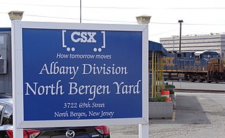
The North Bergen Yard is freight rail yard and intermodal terminal in North Bergen, New Jersey parallel to Tonnelle Avenue between 49th and 69th Streets. Located within the North Jersey Shared Assets Area, the facility is part of CSX Transportation (CSXT) and the origination point of its CSX River Subdivision at the southern end of the Albany Division. On its west side, the New York, Susquehanna and Western Railway (NYSW) runs the length of the yard and operates a bulk transloading operation immediately adjacent to it.

WR Draw is an out-of-service railroad bridge crossing the Passaic River between Newark and the Arlington section of Kearny, New Jersey. The plate girder rim-bearing swing bridge, originally built in 1897 and modified in 1911 and 1950, is the 14th bridge from the river's mouth at Newark Bay and is 8.1 miles (13.0 km) upstream from it. Last used for regular passenger service in 2002, it is welded in closed position as its height is not considered a hazard to navigation.
The Newark Branch was a branch of the Erie Railroad in New Jersey, United States, running between Jersey City and Paterson and passing through the Broadway Section in North Newark, the origin of its name. Inaugurated in the 1870s, the line was last used for passenger service on September 30, 1966 but continues to be used for freight service on a portion of its length.
The PD Draw is a partially dismantled railroad bridge on the Passaic River between Newark and Kearny in the US state of New Jersey. It was built as part of Central Railroad of New Jersey branch known as the Newark and New York Railroad. The swing bridge is the first crossing upstream from Newark Bay at mile point 1.2.

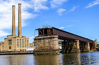
Point-No-Point Bridge is a railroad bridge crossing the Passaic River between Newark and Kearny, New Jersey, United States, in the New Jersey Meadowlands. The swing bridge is the fourth from the river's mouth at Newark Bay and is 2.6 miles (4.2 km) upstream from it. A camelback through truss bridge, it is owned by Conrail as part of its North Jersey Shared Assets and carries the Passaic and Harsimus Line used by CSX Transportation and Norfolk Southern. River Subdivision accesses the line via Marion Junction. Conrail replacing the bridge, which was opened in 1901. Work began in Novemeber 2022.

The Lincoln Highway Passaic River Bridge is a vehicular moveable bridge crossing the Passaic River at a point 1.8 mi (2.9 km) from the river mouth at Newark Bay in northeastern New Jersey, United States. The vertical lift bridge, along the route of the Lincoln Highway, carries U.S. Route 1/9 Truck and the East Coast Greenway between the Ironbound section of Newark and Kearny Point in Kearny. Opened in 1941, it is owned by and operated by the New Jersey Department of Transportation (NJDOT) and required by the Code of Federal Regulations to open on 4-hour notice for maritime traffic.


