
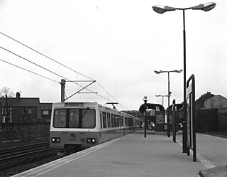
The Tyne and Wear Metro is an overground and underground light rail rapid transit system serving Newcastle upon Tyne, Gateshead, North Tyneside, South Tyneside, and the City of Sunderland. The network opened in stages from August 1980 and now serves a total of 60 stations, with two lines covering 77.5 km (48.2 mi) of track. The Metro can be accessed from a mixture of under ground and above ground stations. It has been described as the "first modern light rail system in the United Kingdom". The system is currently owned and operated by the Tyne and Wear Passenger Transport Executive, thus is fully under public ownership and operation.

The Durham Coast Line is an approximately 39.5-mile (63.6 km) railway line running between Newcastle and Middlesbrough in North East England. Heavy rail passenger services, predominantly operated Northern Trains, and some freight services operate over the whole length of the line; it provides an important diversionary route at times when the East Coast Main Line is closed. Light rail services of the Tyne and Wear Metro's Green Line also operate over the same tracks between a junction just south of Sunderland station and Pelaw Junction.

Heworth Interchange consists of a National Rail, Tyne and Wear Metro and bus station. It is located in the suburb of Heworth, Gateshead in Tyne and Wear, England, and opened on 5 November 1979 for rail and bus services. The station joined the Tyne and Wear Metro network around two years later, on 15 November 1981.

The Leamside Line, originally part of the Durham Junction Railway, is a disused railway line, located in the North East of England. The alignment diverges from the East Coast Main Line at Tursdale Junction, travelling a distance of 21 miles north through the Durham Coalfield and Washington, prior to joining the Durham Coast Line at Pelaw Junction. The Leamside Line closed to passenger traffic in 1964, under the Beeching cuts.

Brockley Whins is a Tyne and Wear Metro station, serving the suburbs of Boldon Colliery and Brockley Whins, South Tyneside in Tyne and Wear, England. It joined the network on 31 March 2002, following the opening of the extension from Pelaw to South Hylton.

Pelaw is a Tyne and Wear Metro station, serving the suburbs of Bill Quay, Pelaw and Wardley, Gateshead in Tyne and Wear, England. It joined the network on 15 September 1985.

Sunderland is a railway station on the Durham Coast Line, which runs between Newcastle and Middlesbrough via Hartlepool. The station, situated 12 miles 15 chains (19.6 km) south-east of Newcastle, serves the port city of Sunderland in Tyne and Wear, England. It is owned by Network Rail and managed by Northern Trains. Since 31 March 2002, the station has also been served by the Tyne and Wear Metro.

University is a Tyne and Wear Metro station, serving the University of Sunderland and suburb of Ashbrooke, City of Sunderland in Tyne and Wear. It joined the network on 31 March 2002, following the opening of the extension from Pelaw to South Hylton.

West Monkseaton is a Tyne and Wear Metro station, serving the village of Earsdon and suburb of Monkseaton, North Tyneside in Tyne and Wear, England. It joined the network on 11 August 1980, following the opening of the first phase of the network, between Haymarket and Tynemouth via Four Lane Ends.

The Tyneside Electrics were the suburban railways on Tyneside that the North Eastern Railway and the London and North Eastern Railway electrified using the third rail system. The North Tyneside Loop was electrified from 1904 onwards and formed one of the earliest suburban electric networks; the South Tyneside line to South Shields via Pelaw was electrified in March 1938. British Railways converted these lines to diesel operation in the 1960s: the line to South Shields in January 1963 and the North Tyneside lines in June 1967 when the electrical supply infrastructure and the rolling stock had become life expired. In addition, the system was losing passengers and suffering from costly vandalism. Since the late 1970s, much of the system has been converted to form the Tyne and Wear Metro.

Jarrow is a Tyne and Wear Metro station, serving the town of Jarrow, South Tyneside in Tyne and Wear, England. It joined the network on 24 March 1984, following the opening of the fifth phase of the network, between Heworth and South Shields.

Central Station is an underground Tyne and Wear Metro station, serving the Grainger Town area of the city of Newcastle upon Tyne in Tyne and Wear, England. It joined the network on 15 November 1981, following the opening of the third phase of the network, between Haymarket and Heworth. The station is named after Newcastle Central railway station, which stands directly above it.
Felling is a Tyne and Wear Metro station, serving the suburb of Felling, Gateshead in Tyne and Wear, England. It joined the network on 15 November 1981, following the opening of the third phase of the network, between Haymarket and Heworth.

Tyne and Wear is a metropolitan area covering the cities of Newcastle upon Tyne and Sunderland, as well as North and South Tyneside, Gateshead and Washington.
The accident at St Bedes Junction was one of several serious accidents in 1915. It featured a double collision and fire fuelled by gas, characteristics shared by a much worse accident that year at Quintinshill. There were also similarities in that a signalman was unaware of the presence of a train near his signal box and rules were not observed. The accident is sometimes referred to as the Jarrow railway disaster as there was no station at Bede and Jarrow was then the nearest place of importance.
Gateshead railway station served the town of Gateshead, England between 1844 and 1981. It was situated on the northern and western sides of the triangular junction to the south of the High Level Bridge which connects Gateshead with Newcastle upon Tyne. There were two portions to the station on different routes; at times they were known as Gateshead East and Gateshead West.
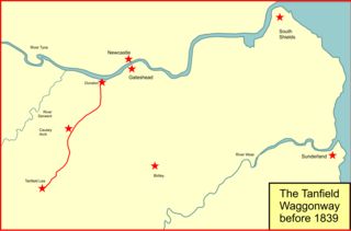
The Brandling Junction Railway was an early railway in County Durham, England. It took over the Tanfield Waggonway of 1725 that was built to bring coal from Tanfield to staiths on the River Tyne at Dunston. The Brandling Junction Railway itself opened in stages from 1839, running from Gateshead to Wearmouth and South Shields. Wearmouth was regarded at the time as the "Sunderland" terminal.

Penshaw railway station served the village of Penshaw, Tyne and Wear, England from 1840 to 1964 on the Leamside line.

Washington railway station served the town of Washington, Tyne and Wear, England from 1835 to 1963, initially on the Stanhope & Tyne Railway and later the Leamside line.

Ryhoperailway station was one of two railway stations to have served the village of Ryhope, Tyne & Wear. For much of its existence, it was served by the Durham–Sunderland and Hartlepool–Haswell–Sunderland lines.
