Spindale, North Carolina

Last updated

Spindale, North Carolina
Spindale-House-nc.jpg
Spindale House
Nickname: 
The Dale
Motto: 
Small Town Friendly
NCMap-doton-Spindale.PNG
Location of Spindale, North Carolina
Coordinates: 35°21′35″N81°55′24″W / 35.35972°N 81.92333°W / 35.35972; -81.92333
Country United States
State North Carolina
County Rutherford
Area
[1]
  Total5.41 sq mi (14.01 km2)
  Land5.41 sq mi (14.01 km2)
  Water0.00 sq mi (0.00 km2)
Elevation
[2]
994 ft (303 m)
Population
 (2020)
  Total4,225
  Density781.25/sq mi (301.66/km2)
Time zone UTC-5 (Eastern (EST))
  Summer (DST) UTC-4 (EDT)
ZIP code
28160
Area code 828
FIPS code 37-63880 [3]
GNIS feature ID2407383 [2]
Website www.spindalenc.net/home

Spindale is a town in Rutherford County, North Carolina, United States. The population was 4,321 at the 2010 census.

Contents

History

Spindale originated as a mill town from its first textile mill, Spencer Mills, in 1916, until its last textile mill, Stonecutter Mills, organized by J. B. Tanner in 1920, which closed in 1999. [4] The town of Spindale was incorporated on August 21, 1923. [5] In 1939, the North Carolina General Assembly passed a local act that extended the corporate limits of the town of Spindale, which nearly doubled its size in area. [6]

In 1926, the iconic Spindale House was opened as a community and recreation center and as a memorial building, presented to the town by K. S. Tanner and other members of the Tanner family. [7]

Opening in 1926, a classic landmark of the Spindale mill village was Greene's Grocery Store located on Spindale Street, which stood for over five decades as the number one volume store for many mill families, featuring a home delivery truck service, a credit account system, and a fresh meat market. [8]

The first organized churches in Spindale were First Baptist in 1917, Methodist in 1919, Presbyterian in 1922, and Spencer Baptist in 1926. [9]

In 1930, the Carolina Theater opened on Main Street in Spindale, which could seat 360 patrons and operated until it closed in 1961. [10]

The Spindale Sun newspaper was established in 1941. [11]

Geography

Spindale is located along U.S. Route 221A between Forest City to the southeast and Rutherfordton to the west. U.S. Route 74A passes through the southern part of town.

According to the United States Census Bureau, the town has a total area of 5.5 square miles (14 km2), all of it land.

Demographics

Historical population
CensusPop.Note
1930 3,066
1940 3,95228.9%
1950 3,891−1.5%
1960 4,0824.9%
1970 3,848−5.7%
1980 4,24610.3%
1990 4,040−4.9%
2000 4,022−0.4%
2010 4,3217.4%
2020 4,225−2.2%
U.S. Decennial Census [12]

2020 census

Spindale racial composition [13]
RaceNumberPercentage
White (non-Hispanic)2,75865.3%
Black or African American (non-Hispanic)1,00423.8%
Native American 260.6%
Asian 290.7%
Pacific Islander 60.1%
Other/Mixed 2505.9%
Hispanic or Latino 1523.6%

As of the 2020 United States census, there were 4,225 people, 1,564 households, and 938 families residing in the town.

2000 census

At the 2000 census there were 4,022 people, 1,662 households, and 1,065 families in the town. The population density was 726.8 inhabitants per square mile (280.6/km2). There were 1,887 housing units at an average density of 341.0 per square mile (131.7/km2). The racial makeup of the town was 72.8% White, 24.9% African American, 0.5% Native American, 0.6% Asian, 0.5% from other races, and 0.8% from two or more races. Hispanic or Latino of any race were 1.44%. [3]

Of the 1,662 households 25.6% had children under the age of 18 living with them, 43.9% were married couples living together, 14.7% had a female householder with no husband present, and 35.9% were non-families. 33.3% of households were one person and 15.2% were one person aged 65 or older. The average household size was 2.29 and the average family size was 2.87.

The age distribution was 22.2% under the age of 18, 8.2% from 18 to 24, 29.5% from 25 to 44, 22.5% from 45 to 64, and 17.6% 65 or older. The median age was 38 years. For every 100 females, there were 97.7 males. For every 100 females age 18 and over, there were 97.0 males.

The median household income was $23,365 and the median family income was $33,583. Males had a median income of $25,504 versus $20,395 for females. The per capita income for the town was $13,789. About 12.5% of families and 16.5% of the population were below the poverty line, including 21.0% of those under age 18 and 15.9% of those age 65 or over.

Education

Spindale is home to Isothermal Community College, a two-year community college, named for its location in the thermal belt, and a part of the North Carolina Community College system.

Media

WNCW, a noncommercial radio station affiliated with NPR, broadcasts from Isothermal Community College on a frequency of 88.7mhz. WNCW's programming consists of a diverse blend of musical styles. Its eclectic music mix and presence on the World Wide Web attracts listeners well beyond the reach of its coverage area.

Notable person

See also

Main Street, Spindale, North Carolina.jpg
Main Street

Related Research Articles

<span class="mw-page-title-main">Chester County, South Carolina</span> County in South Carolina, United States

Chester County is a county located in the U.S. state of South Carolina. As of the 2020 census, its population was 32,294. Its county seat is Chester.

<span class="mw-page-title-main">Rutherford County, North Carolina</span> County in North Carolina, United States

Rutherford County is a county in the southwestern area of the U.S. state of North Carolina. As of the 2020 census, the population was 64,444. Its county seat is Rutherfordton. Rutherford County comprises the Forest City, NC Micropolitan Statistical Area.

<span class="mw-page-title-main">Polk County, North Carolina</span> County in North Carolina, United States

Polk County is a county located in the U.S. state of North Carolina. As of the 2020 census, the population was 19,328. Its county seat is Columbus.

<span class="mw-page-title-main">Cleveland County, North Carolina</span> County in North Carolina, United States

Cleveland County is a county located in the foothills of the Blue Ridge Mountains and the western Piedmont, on the southern border of the U.S. state of North Carolina. As of the 2020 census, the population was 99,519. Its county seat is Shelby. Cleveland County comprises the Shelby-Kings Mountain, NC Micropolitan Statistical Area, which is also included in the Charlotte-Concord, NC-SC Combined Statistical Area.

<span class="mw-page-title-main">Rutherford College, North Carolina</span> Town in North Carolina, United States

Rutherford College is a town in Burke County, North Carolina, United States. As of the 2010 census, the town population was 1,341. It is part of the Hickory–Lenoir–Morganton Metropolitan Statistical Area.

<span class="mw-page-title-main">Hope Mills, North Carolina</span> Town in North Carolina, United States

Hope Mills is a town in Cumberland County, North Carolina, United States. Its population was 15,176 at the 2010 census.

<span class="mw-page-title-main">High Shoals, North Carolina</span> City in North Carolina, United States

High Shoals is a city in Gaston County, North Carolina, United States, named for the high rocky shoal across the Catawba River. The population was 696 at the 2010 census.

<span class="mw-page-title-main">Ranlo, North Carolina</span> Town in North Carolina, United States

Ranlo is a small town in Gaston County, North Carolina, United States and a suburb of Charlotte, located north of Gastonia. As of the 2020 census, the town population was 4,511, up from 3,434 in 2010.

<span class="mw-page-title-main">Princeton, North Carolina</span> Town in North Carolina, United States

Princeton is a town in Johnston County, North Carolina, United States. As of the 2010 census it had a population of 1,194. Each May the town celebrates Princeton Community Day, a festival dedicated to promoting community involvement and town pride. The town holds municipal elections in November in odd-number years to elect its mayor and town council.

<span class="mw-page-title-main">Carolina Beach, North Carolina</span> Town in North Carolina, United States

Carolina Beach is a beach town in New Hanover County, North Carolina, United States, situated about 12 miles (19 km) south of Wilmington International Airport in southeastern coastal North Carolina. As of the 2020 census, the city population was 6,564. It is part of the Wilmington metropolitan area. The community of Wilmington Beach was annexed by the town in 2000.

<span class="mw-page-title-main">Randleman, North Carolina</span> City in North Carolina, United States

Randleman is a city in Randolph County, North Carolina, United States. The population was 4,113 at the 2010 census. It is the home of NASCAR's Petty family, the Victory Junction Gang Camp and was the location of the Richard Petty Museum from 2003 to 2014.

<span class="mw-page-title-main">Pembroke, North Carolina</span> Town in North Carolina, United States

Pembroke is a town in Robeson County, North Carolina, United States. It is about 90 miles inland and northwest from the Atlantic Coast. The population was 2,823 at the 2020 census. The town is the seat of the state-recognized Lumbee tribe of North Carolina, as well as the home of the University of North Carolina at Pembroke.

<span class="mw-page-title-main">St. Pauls, North Carolina</span> Town in North Carolina, United States

St. Pauls is a town in Robeson County, North Carolina, United States. The population was 2,035 at the 2010 census.

<span class="mw-page-title-main">Mayodan, North Carolina</span> Town in North Carolina, United States

Mayodan is a town in Rockingham County, North Carolina, in the United States. It is a manufacturing site for Sturm, Ruger & Co., Bridgestone Aircraft Tire, and formerly General Tobacco. Washington Mills Company, later Tultex, operated a textile mill in Mayodan until 1999.

<span class="mw-page-title-main">Cleveland, North Carolina</span> Town in North Carolina, United States

Cleveland is a town in the Cleveland Township of Rowan County, North Carolina, United States. The population was 871 at the 2010 census.

<span class="mw-page-title-main">Bostic, North Carolina</span> Town in North Carolina, United States

Bostic is a town in Rutherford County, North Carolina, United States. The population was 386 at the 2010 census.

<span class="mw-page-title-main">Forest City, North Carolina</span> Town in North Carolina, United States

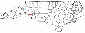
Forest City, formerly known as "Burnt Chimney," is a town in Rutherford County, North Carolina, United States. The population was 7,377 as of the 2020 census, making it the most populous municipality in Rutherford County.

<span class="mw-page-title-main">Ruth, North Carolina</span> Town in North Carolina, United States

Ruth is a town in Rutherford County, North Carolina, United States. The population was 440 at the 2010 census.

<span class="mw-page-title-main">Rutherfordton, North Carolina</span> Town in North Carolina, United States

Rutherfordton is a town and the county seat of Rutherford County, North Carolina, United States. The population was 4,213 at the 2010 census.

<span class="mw-page-title-main">Alberta, Virginia</span> Town in Virginia, United States

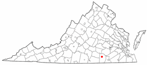
Alberta is a town in Brunswick County, Virginia, United States. The population was 302 at the 2020 census. It is home to the Christanna Campus of Southside Virginia Community College.

References

  1. "ArcGIS REST Services Directory". United States Census Bureau. Retrieved September 20, 2022.
  2. 1 2 U.S. Geological Survey Geographic Names Information System: Spindale, North Carolina
  3. 1 2 "U.S. Census website". United States Census Bureau . Retrieved January 31, 2008.
  4. Barth, Tim; Murrell, Duncan (April 2, 2004). "A Short History of Stonecutter Mills and Spindale, North Carolina" (PDF). University of North Carolina at Chapel Hill.
  5. Clarence W. Griffin, "History of Old Tryon and Rutherford Counties, North Carolina, 1730–1936," Miller Printing Company (1937), pp. 501.
  6. Griffin, Clarence W. (1952). History of Rutherford County, 1937–1951. Inland Press.
  7. Griffin 1937 p. 503.
  8. Todd Lavender. “Forgotten Rutherford County: Images of Our Hometowns; Stories From Our Past.” Akmaeon Publishing. 2017. pp. 199–200.
  9. Griffin 1937 pp. 581–594.
  10. “Carolina Theatre Spindale, NC.” Cinema Treasures. Retrieved March 12, 2021.
  11. Griffin 1952 p. 17.
  12. "Census of Population and Housing". Census.gov. Retrieved June 4, 2015.
  13. "Explore Census Data". data.census.gov. Retrieved December 21, 2021.
  14. North Carolina Manual, 2003–2004. North Carolina Department of the Secretary of State. 2004. p. 500.