St. Anthony, Stearns County, Minnesota

Last updated

St. Anthony, Minnesota
St. Anthony, Stearns County, Minnesota.jpg
St. Anthony, Stearns County
Stearns County Minnesota Incorporated and Unincorporated areas St. Anthony Highlighted.svg
Location of the city of St. Anthony
within Stearns County, Minnesota
Coordinates: 45°41′20″N94°36′42″W / 45.68889°N 94.61167°W / 45.68889; -94.61167
CountryUnited States
State Minnesota
County Stearns
Founded1880
Incorporated May 31, 1911
Government
   Mayor Robert Cremers
Area
[1]
  Total0.493 sq mi (1.276 km2)
  Land0.493 sq mi (1.276 km2)
  Water0.000 sq mi (0.000 km2)
Elevation
[2]
1,273 ft (388 m)
Population
 (2020) [3]
  Total91
  Estimate 
(2022) [4]
92
  Density184.5/sq mi (71.22/km2)
Time zone UTC–6 (Central (CST))
  Summer (DST) UTC–5 (CDT)
ZIP Code
56307
Area code 320
FIPS code 27-56698
GNIS feature ID2396472 [2]
Sales tax 7.125%

St. Anthony or Saint Anthony is a city in Stearns County, Minnesota, United States. The population was 91 at the 2020 census. [3] It is part of the St. Cloud Metropolitan Statistical Area. Main routes include Minnesota State Highway 238, Stearns County Road 153, and Trobec Street.

Contents

History

St. Anthony in Stearns County was settled circa 1880 and incorporated on May 31, 1911. [5]

St. Anthony Catholic Church St. Anthony Church, St. Anthony, Stearns County, Minnesota.jpg
St. Anthony Catholic Church

Geography

According to the United States Census Bureau, the city has a total area of 0.493 square miles (1.28 km2), all land. [1]

The city of St. Anthony is located within Krain Township geographically but is a separate entity. Nearby places include Albany and Freeport.

Demographics

Historical population
CensusPop.Note
1920 161
1930 62−61.5%
1940 9045.2%
1950 66−26.7%
1960 729.1%
1970 66−8.3%
1980 7818.2%
1990 813.8%
2000 9011.1%
2010 86−4.4%
2020 915.8%
2022 (est.)92 [4] 1.1%
U.S. Decennial Census [6]
2020 Census [3]

2010 census

As of the 2010 census, there were 86 people, 30 households, and 23 families living in the city. The population density was 175.5 inhabitants per square mile (67.8/km2). There were 33 housing units at an average density of 67.3 per square mile (26.0/km2). The racial makeup of the city was 98.8% White and 1.2% from other races. Hispanic or Latino of any race were 1.2% of the population.

There were 30 households, of which 43.3% had children under the age of 18 living with them, 73.3% were married couples living together, 3.3% had a male householder with no wife present, and 23.3% were non-families. 20.0% of all households were made up of individuals, and 10% had someone living alone who was 65 years of age or older. The average household size was 2.87 and the average family size was 3.39.

The median age in the city was 33.3 years. 36% of residents were under the age of 18; 5.9% were between the ages of 18 and 24; 34.9% were from 25 to 44; 15.2% were from 45 to 64; and 8.1% were 65 years of age or older. The gender makeup of the city was 47.7% male and 52.3% female.

2000 census

As of the 2000 census there were 90 people, 32 households, and 24 families living in the city. The population density was 183.7 inhabitants per square mile (70.9/km2). There were 36 housing units at an average density of 73.5 per square mile (28.4/km2). The racial makeup of the city was 98.89% White, and 1.11% Asian. 81.9% were of German, 5.3% Irish and 5.3% Norwegian ancestry.

There were 32 households, out of which 37.5% had children under the age of 18 living with them, 71.9% were married couples living together, 3.1% had a female householder with no husband present, and 21.9% were non-families. 15.6% of all households were made up of individuals, and 6.3% had someone living alone who was 65 years of age or older. The average household size was 2.81 and the average family size was 3.16.

In the city, the population was spread out, with 24.4% under the age of 18, 11.1% from 18 to 24, 33.3% from 25 to 44, 20.0% from 45 to 64, and 11.1% who were 65 years of age or older. The median age was 32 years. For every 100 females, there were 95.7 males. For every 100 females age 18 and over, there were 88.9 males.

The median income for a household in the city was $29,107, and the median income for a family was $30,000. Males had a median income of $26,875 versus $18,750 for females. The per capita income for the city was $13,736. There were 8.3% of families and 15.2% of the population living below the poverty line, including 32.0% of under eighteens and 11.8% of those over 64.

Related Research Articles

Avon Township is a township in Stearns County, Minnesota, United States. The population was 2,294 at the 2010 census. The township includes the city of Avon.

<span class="mw-page-title-main">Freeport, Minnesota</span> City in Minnesota, United States

Freeport is a city in Stearns County, Minnesota, United States. The population was 632 at the 2010 census. Freeport is part of the St. Cloud Metropolitan Statistical Area.

<span class="mw-page-title-main">Greenwald, Minnesota</span> City in Minnesota, United States

Greenwald is a city in Stearns County, Minnesota, United States. The population was 222 at the 2010 census. It is part of the St. Cloud Metropolitan Statistical Area.

Grove Township is a township in Stearns County, Minnesota, United States. The population was 493 at the 2010 census. The township includes the southern one-third of the City of Melrose and the City of Greenwald.

<span class="mw-page-title-main">Kimball, Minnesota</span> City in Minnesota, United States

Kimball is a city in Stearns County, Minnesota, United States. The population was 799 at the 2020 census. It is part of the St. Cloud Metropolitan Statistical Area.

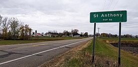
Krain Township is a township in Stearns County, Minnesota, United States. The population was 981 at the 2010 census. The township includes the city of St. Anthony.

<span class="mw-page-title-main">Lake Henry, Minnesota</span> City in Minnesota, United States

Lake Henry is a city in Stearns County, Minnesota, United States. The population was 103 at the 2010 census. It is part of the St. Cloud Metropolitan Statistical Area.

Lake Henry Township is a township in Stearns County, Minnesota, United States. The population was 278 at the 2010 census.

<span class="mw-page-title-main">New Munich, Minnesota</span> City in Minnesota, United States

New Munich is a city in Stearns County, Minnesota, United States. The population was 320 at the 2010 census. It is part of the St. Cloud Metropolitan Statistical Area.

<span class="mw-page-title-main">Roscoe, Minnesota</span> City in Minnesota, United States

Roscoe is a city in Stearns County, Minnesota, United States. The population was 102 at the 2010 census. It is part of the St. Cloud Metropolitan Statistical Area. On December 7, 2016, Donald Kennith Albrecht was sworn in as mayor of Roscoe.

<span class="mw-page-title-main">St. Martin, Minnesota</span> City in Minnesota, United States

St. Martin or Saint Martin, Smartin to locals, is a city in Stearns County, Minnesota, United States. The population was 308 at the 2010 census. It is part of the St. Cloud Metropolitan Statistical Area.

<span class="mw-page-title-main">St. Rosa, Minnesota</span> City in Minnesota, United States

Saint Rosa is a city in Stearns County, Minnesota, United States. The population was 58 at the 2020 census. It is part of the St. Cloud Metropolitan Statistical Area.

Wakefield Township is a township in Stearns County, Minnesota, United States. The township includes the cities of Cold Spring and Richmond. The population was 2,756 at the 2010 census.

<span class="mw-page-title-main">Meire Grove, Minnesota</span> City in Minnesota, United States

Meire Grove is a city in Stearns County, Minnesota, United States. The population was 179 at the 2010 census. It is part of the St. Cloud Metropolitan Statistical Area.

<span class="mw-page-title-main">Spring Hill, Minnesota</span> City in Minnesota, United States

Spring Hill is a city in Stearns County, Minnesota, United States. The population was 85 at the 2010 census. It is part of the St. Cloud Metropolitan Statistical Area.

<span class="mw-page-title-main">St. Stephen, Minnesota</span> City in Minnesota, United States

Saint Stephen is a city in Stearns County, Minnesota, United States. The population was 797 at the 2020 census.

<span class="mw-page-title-main">South Haven, Minnesota</span> City in Minnesota, United States

South Haven is a city in Wright County, Minnesota, United States. The population was 187 at the 2010 census.

<span class="mw-page-title-main">Eden Valley, Minnesota</span> City in Minnesota, United States

Eden Valley is a city in Meeker and Stearns counties in the U.S. state of Minnesota. The population was 1,027 at the 2020 census. Most of Eden Valley is in Meeker County; the Stearns County portion is part of the St. Cloud Metropolitan Statistical Area.

<span class="mw-page-title-main">Brooten, Minnesota</span> City in Minnesota, United States

Brooten is a city in Stearns and Pope counties in the U.S. state of Minnesota, United States. The population was 626 as of the 2020 census. Almost the entire city is within Stearns County, with a small portion in Pope County.

<span class="mw-page-title-main">Clearwater, Minnesota</span> City in Minnesota, United States

Clearwater is a city in Stearns and Wright counties in the U.S. state of Minnesota. The population was 1,922 at the 2020 census. Most of the city lies within Wright County.

References

  1. 1 2 "2023 U.S. Gazetteer Files". United States Census Bureau. Retrieved February 29, 2024.
  2. 1 2 U.S. Geological Survey Geographic Names Information System: St. Anthony, Stearns County, Minnesota
  3. 1 2 3 "Explore Census Data". United States Census Bureau . Retrieved February 29, 2024.
  4. 1 2 "City and Town Population Totals: 2020–2022". United States Census Bureau. February 29, 2024. Retrieved February 29, 2024.
  5. Minnesota Place Names. Minnesota Historical Society. Accessed January 12, 2015.
  6. "Census of Population and Housing". United States Census Bureau. Retrieved June 4, 2015.