St. George, Maine

Last updated

St. George, Maine
Knox County Maine incorporated and unincorporated areas St. George highlighted.svg
Location in Knox County and the state of Maine
Coordinates: 44°00′59″N69°11′56″W / 44.0164709°N 69.1989341°W / 44.0164709; -69.1989341
CountryUnited States
State Maine
County Knox
IncorporatedFebruary 7, 1803
VillagesSt. George
Clark Island
Glenmere
Long Cove
Martinsville
Port Clyde
Spruce Head
Tenants Harbor
Area
[1]
  Total117.25 sq mi (303.68 km2)
  Land25.02 sq mi (64.80 km2)
  Water92.23 sq mi (238.87 km2)
Population
 (2020)
  Total2,594
  Density104/sq mi (40.0/km2)
Time zone UTC-5 (Eastern (EST))
  Summer (DST) UTC-4 (EDT)

St. George is a town in Knox County, Maine, United States. It includes the villages of Port Clyde and Tenants Harbor, with the latter being town's commercial center. A favorite with artists, writers and naturalists, St. George is home to the Brothers and Hay Ledge nature preserve, comprising four islands off Port Clyde. The town's population stands at 2,594 residents, according to the 2020 Census. [2]

Contents

History

The peninsula and its islands were noted for immense flocks of duck, geese and other waterfowl. Although the region was part of the Waldo Patent, General Samuel Waldo complied with requests from Abenaki Indians not to settle immigrants at what was their prized hunting ground. Consequently, the peninsula remained unpopulated until after the close of the French and Indian Wars in 1763. The Revolutionary War further slowed development, but during the 1780s, there was rapid settlement of the peninsula. It was incorporated in 1789 as part of Cushing. On February 7, 1803, the peninsula and its islands were set off and incorporated as St. George, taking its name from the river.

Farmers grew potatoes. After 1830, granite was quarried and shipped nationally for construction. Shipbuilders annually produced three to four vessels, many for the coasting trade, exporting cordwood, lumber and fish. Factories canned lobsters, clams and sardines. In the 1880s, the town's rugged oceanfront beauty was discovered by "rusticators"—visitors, including artists, who bought or built summer cottages.

At the town office, there is a statue of Saint George, the town's namesake, fighting the legendary dragon. [3]

Geography

According to the United States Census Bureau, the town has a total area of 117.25 square miles (303.68 km2), of which 25.02 square miles (64.80 km2) is land and 92.23 square miles (238.87 km2) is water. [1] Bounded on the west by the Saint George River, the town is located on a peninsula extending into the Gulf of Maine.

St. George is crossed by state route 131. It borders the town of South Thomaston to the north.

Both Allen Island and Mosquito Island House are listed on the National Register of Historic Places for St. George.

Demographics

Historical population
CensusPop.Note
1790 578
1800 88653.3%
1810 1,16831.8%
1820 1,32513.4%
1830 1,64324.0%
1840 2,09427.4%
1850 2,2175.9%
1860 2,71622.5%
1870 2,318−14.7%
1880 2,87524.0%
1890 2,491−13.4%
1900 2,206−11.4%
1910 2,201−0.2%
1920 1,654−24.9%
1930 2,10827.4%
1940 1,550−26.5%
1950 1,482−4.4%
1960 1,5887.2%
1970 1,6393.2%
1980 1,94818.9%
1990 2,26116.1%
2000 2,58014.1%
2010 2,5910.4%
2020 2,5940.1%
U.S. Decennial Census [4]

2010 census

As of the census [5] of 2010, there were 2,591 people, 1,204 households, and 768 families residing in the town. The population density was 103.6 inhabitants per square mile (40.0/km2). There were 2,107 housing units at an average density of 84.2 per square mile (32.5/km2). The racial makeup of the town was 98.8% White, 0.2% African American, 0.1% Asian, and 0.8% from two or more races. Hispanic or Latino of any race were 0.5% of the population.

There were 1,204 households, of which 21.0% had children under the age of 18 living with them, 51.9% were married couples living together, 6.6% had a female householder with no husband present, 5.3% had a male householder with no wife present, and 36.2% were non-families. 29.7% of all households were made up of individuals, and 14.3% had someone living alone who was 65 years of age or older. The average household size was 2.15 and the average family size was 2.60.

The median age in the town was 51.7 years. 17.3% of residents were under the age of 18; 4.6% were between the ages of 18 and 24; 17.8% were from 25 to 44; 35.4% were from 45 to 64; and 24.9% were 65 years of age or older. The gender makeup of the town was 48.6% male and 51.4% female.

2000 census

As of the census [6] of 2000, there were 2,580 people, 1,119 households, and 757 families residing in the town. The population density was 100.9 inhabitants per square mile (39.0/km2). There were 1,777 housing units at an average density of 69.5 per square mile (26.8/km2). The racial makeup of the town was 98.68% White, 0.16% African American, 0.23% Native American, 0.35% Asian, 0.04% from other races, and 0.54% from two or more races. Hispanic or Latino of any race were 0.23% of the population.

There were 1,119 households, out of which 28.2% had children under the age of 18 living with them, 57.8% were married couples living together, 7.0% had a female householder with no husband present, and 32.3% were non-families. 26.5% of all households were made up of individuals, and 12.4% had someone living alone who was 65 years of age or older. The average household size was 2.31 and the average family size was 2.77.

In the town, the population was spread out, with 22.1% under the age of 18, 4.3% from 18 to 24, 24.5% from 25 to 44, 28.2% from 45 to 64, and 21.0% who were 65 years of age or older. The median age was 44 years. For every 100 females, there were 96.5 males. For every 100 females age 18 and over, there were 93.7 males.

The median income for a household in the town was $41,211, and the median income for a family was $48,162. Males had a median income of $33,929 versus $25,439 for females. The per capita income for the town was $23,272. About 3.8% of families and 8.6% of the population were below the poverty line, including 11.7% of those under age 18 and 7.7% of those age 65 or over.

Education

According to Roy Meservey, the first school in St. George served the children of Samuel Watts in the 1780s. [7] In 1792, four school districts were laid out, and more were created as the town's population grew. [7] At their peak in the late 1800s, there were 18 or 20 schools in St. George. [7] As the population decreased, most of the districts were consolidated, and by the 1950s, only four remained: St. George, Clark's Island, Port Clyde, and Tenants Harbor. [7] In 1957, despite strong public opposition, the St. George, Clark's Island, and Port Clyde schools were all closed. [7] Only Tenants Harbor remained, which all students since have attended under the unified name 'St. George School.' [7] St. George School is a public K–8 school operated by the St. George Municipal School Unit, and has 180 students. [8] [9]

St. George High School was established in 1894 in the sail loft over Long's Store. [7] Its building was erected in 1900, graduating its first class in 1901. [7] It, too, closed as a result of population decline, graduating its last class in 1962. [7] For the 1962–1963 academic year, high school students attended Georges Valley High School in Thomaston. [7] The old building was used as the new elementary school, before being demolished a few years later and replaced by the current town office and fire station. [7]

Starting in the 2015–2016 academic year, St. George students in grades 9–12 began attending one of five schools of their choice: [8]

Places of worship

Notable people

Sites of interest

Related Research Articles

<span class="mw-page-title-main">Harpswell, Maine</span> Town in the state of Maine, United States

Harpswell is a town in Cumberland County, Maine, United States, within Casco Bay in the Gulf of Maine. The population was 5,031 at the 2020 census. Harpswell is composed of land contiguous with the rest of Cumberland County, called Harpswell Neck, as well as three large islands connected by bridges: Sebascodegan Island, Orr's Island, and Bailey Island and over 200 smaller islands. Harpswell is part of the Portland–South Portland–Biddeford, Maine Metropolitan Statistical Area.

Frenchboro is a town in Hancock County, Maine, United States, and a village within this town located on Long Island, southeast of Swans Island. The population was 29 at the 2020 census. The town is accessible by state ferry service from Bass Harbor.

<span class="mw-page-title-main">Gouldsboro, Maine</span> Town in the state of Maine, United States

Gouldsboro is a town and municipality in Hancock County, Maine, United States on the Schoodic Peninsula. The town was named for Robert Gould, a landholder in the town. The town has many historically separate fishing villages, summer colonies and communities, including Birch Harbor, Prospect Harbor, South Gouldsboro, West Gouldsboro, Summer Harbor, Wonsqueak Harbor, Bunker's Harbor, Chicken Mill, Jones' Pond, Westbay, and Corea. The population was 1,703 at the 2020 census.

<span class="mw-page-title-main">Hancock, Maine</span> Town in the state of Maine, United States

Hancock is a town in Hancock County, Maine, United States. The population was 2,466 at the 2020 census. Located on the mainland at the head of Frenchman Bay, Hancock has commanding views of Mount Desert Island.

<span class="mw-page-title-main">Mount Desert, Maine</span> Town in the state of Maine, United States

Mount Desert is a town on Mount Desert Island in Hancock County, Maine, United States. The population was 2,146 at the 2020 census. Incorporated in 1789, the town currently encompasses the villages of Otter Creek, Seal Harbor, Northeast Harbor, Somesville, Hall Quarry, and Pretty Marsh.

<span class="mw-page-title-main">Southwest Harbor, Maine</span> Town in the state of Maine, United States

Southwest Harbor is a town in Hancock County, Maine, United States. Located on Mount Desert Island, the population was 1,756 at the 2020 census. The municipality contains within it the villages of Southwest Harbor, Manset, Seawall, Wonderland, and Pemetic Hills.

Sullivan is a town in Hancock County, Maine, United States. The population was 1,219 at the 2020 census. The town was named for Daniel Sullivan, an early settler. Colloquially referred to as "Sully" or "the Sullivans"—like many Maine municipalities composed of villages with geographic designations of the town proper—the municipality was incorporated in 1789. Located in the Upper Schoodic Peninsula sub-region of Maine's Downeast Acadia region, the municipality has been known as "Waukeag", "New Bristol", and later Sullivan; and once included the nearby communities of Hancock, Sorrento, and what would later be Township 7, South & Middle Districts. Once home to abundant granite quarries, the town of Sullivan is now a residential community for nearby Ellsworth and Mount Desert Island. Located along U.S. Route 1, the Taunton River, and Hog Bay, Sullivan is home to a reversing tidal falls and many scenic turnouts that dot the Schoodic National Scenic Byway along the Upper Schoodic Peninsula.

<span class="mw-page-title-main">Tremont, Maine</span> Town in the state of Maine, United States

Tremont is a town in Hancock County, Maine, United States. It is located on the southwestern side of Mount Desert Island, known to locals as "the quiet side."

<span class="mw-page-title-main">Winter Harbor, Maine</span> Town in the state of Maine, United States

Winter Harbor is a town on the Schoodic Peninsula in Hancock County, Maine, United States. The population was 461 at the 2020 census. The town is located just outside the Schoodic Peninsula portion of Acadia National Park and is due east of the town of Bar Harbor and Ellsworth. Winter Harbor was once the location of a US Naval Station, NSGA-WH, which closed in the mid-2000s, and is now home to the Schoodic Institute’s Education and Research Center.

<span class="mw-page-title-main">Cushing, Maine</span> Town in the state of Maine, United States

Cushing is a town in Knox County, Maine, United States. The population was 1,502 at the 2020 census. A favorite of artists for its unspoiled natural setting, Cushing includes the villages of North Cushing, Cushing, South Cushing, and Pleasant Point.

<span class="mw-page-title-main">Rockport, Maine</span> Town in Maine, United States

Rockport is a town in Knox County, Maine, United States. It is 35 miles southeast of Augusta. The population was 3,644 at the 2020 census. Rockport is a popular tourist destination and art colony.

<span class="mw-page-title-main">Boothbay, Maine</span> Town in Maine, United States

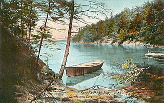
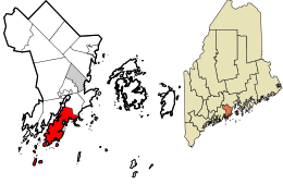
Boothbay is a town in Lincoln County, Maine, United States. The population was 3,003 at the 2020 census. It includes the neighborhoods of Back Narrows, Dover, Linekin, Oak Hill, Ocean Point, Spruce Shores, and the villages of East Boothbay and Trevett. The surrounding Boothbay Region is a center of summer tourist activity, and a significant part of its population does not live there year-round. Five shipyards are located in the town, the largest of which is Washburn & Doughty.

<span class="mw-page-title-main">Southport, Maine</span> Town in the state of Maine, United States

Southport is a town and archipelago in Lincoln County, Maine, United States. The population was 622 at the 2020 census. It includes the neighborhoods of Capitol Island, Cozy Harbor, East Side, Newagen, Pine Cliff, and West Southport, and the village of Squirrel Island. The majority of the town's residents live on its main island, Southport Island.

<span class="mw-page-title-main">Phippsburg, Maine</span> Town in the state of Maine, United States

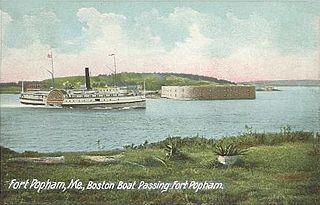
Phippsburg is a town in Sagadahoc County, Maine, United States, on the west side of the mouth of the Kennebec River. The population was 2,155 at the 2020 census. It is within the Portland–South Portland–Biddeford, Maine, metropolitan statistical area. A tourist destination, Phippsburg is home to Bates-Morse Mountain Conservation Area, Fort Popham State Historic Site; it is also home to Fort Baldwin which overlooks Fort Popham, and Popham Beach State Park, as well as Pond Island National Wildlife Refuge. The town includes part of Winnegance.

<span class="mw-page-title-main">Islesboro, Maine</span> Town in Waldo County, Maine, United States

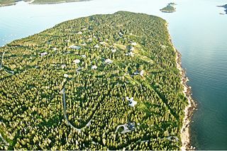
Islesboro is a town in Waldo County, Maine, United States, comprising Islesboro Island and several smaller islands. The population was 583 at the 2020 census. It has a summer colony accessible by state ferry service from Lincolnville Beach three miles to the west, by private boat, or by air taxi service. Home to Warren Island State Park, Islesboro includes the village of Dark Harbor.

<span class="mw-page-title-main">Stockton Springs, Maine</span> Town in the state of Maine, United States

Stockton Springs is a town in Waldo County, Maine, United States. The population was 1,533 at the 2020 census. Stockton Springs is home to Fort Point State Park and Fort Point Light, both located on Fort Point, a peninsula on Cape Jellison.

<span class="mw-page-title-main">Jonesport, Maine</span> Town in Maine, United States

Jonesport is a town in Washington County, Maine, United States. The population was 1,245 at the 2020 census. Jonesport is a fishing and lobstering town. It contains the villages or hamlets of Jonesport, Mason Bay, Monsapec, and West Jonesport.

York is a town in York County, Maine, United States, near the southern tip of the state. The population in the 2020 census was 13,723. Situated beside the Atlantic Ocean on the Gulf of Maine, York is a well-known summer resort town. It is home to three 18-hole golf clubs, four sandy beaches, and Mount Agamenticus. From south to north, it is divided into the villages of Bald Head, York Village, York Harbor, York Beach and Cape Neddick.

Swan's Island is an island town in Hancock County, Maine, United States. It is named after Colonel James Swan, of Fife, Scotland, who purchased the island and some surrounding areas and organized their colonization in the eighteenth century. The population was 355 at the 2020 census. The town is accessible by state ferry service from Bass Harbor.

<span class="mw-page-title-main">Boothbay Harbor, Maine</span> Town in Maine, United States

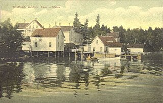
Boothbay Harbor is a town in Lincoln County, Maine, United States. The population was 2,027 at the 2020 census. It includes the neighborhoods of Bayville, Mount Pisgah, and Sprucewold, and the villages of Isle of Springs and West Boothbay Harbor. During summer months, the entire Boothbay Harbor region is a popular yachting and tourist destination.

References

  1. 1 2 "US Gazetteer files 2010". United States Census Bureau . Retrieved December 16, 2012.
  2. "Census - Geography Profile: St. George town, Knox County, Maine" . Retrieved January 16, 2022.
  3. "St. George, Maine: St. George vs. Dragon". RoadsideAmerica.com.
  4. "Census of Population and Housing". Census.gov. Retrieved June 4, 2015.
  5. "U.S. Census website". United States Census Bureau . Retrieved December 16, 2012.
  6. "U.S. Census website". United States Census Bureau . Retrieved January 31, 2008.
  7. 1 2 3 4 5 6 7 8 9 10 11 "History". stgeorgemaine.com. Retrieved March 18, 2016.
  8. 1 2 "Schools". www.stgeorgemaine.com. Retrieved March 18, 2016.
  9. "About | St. George Municipal School Unit". stgeorgemsu.org. Retrieved March 18, 2016.
  10. Roberts, George Simon. Historic towns of the Connecticut River Valley. Robson & Adee, Schenectady, New York, 1906. convenience link
  11. Mears, Bill; Jeane Meserve (July 31, 2007). "Chief justice tumbles after seizure". CNN. Retrieved December 5, 2008.
  12. Sherman, Mark (July 31, 2007). "Chief Justice Roberts Suffers Seizures". The Washington Post. Retrieved December 5, 2008.
  13. "Charles Wilbert Snow". National Governors Association. Archived from the original on November 5, 2012. Retrieved January 15, 2018.
  14. "Tenants Harbor Lighthouse". Lighthouse Friends. Retrieved February 9, 2018.
  15. Tenants Harbor Light.