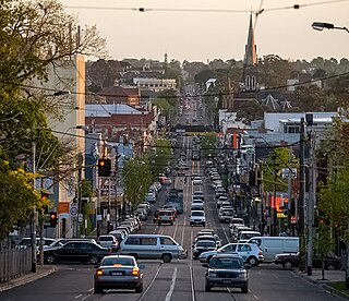
Dandenong Road in 2009, looking west toward St Kilda JunctionSt Kilda Junction looking south before widening, with High Street (now St Kilda Road) to the left and Barkly Street to the right. In the centre is the Junction Hotel.
Up until 1966, St Kilda Junction, along with the Haymarket roundabout on Royal Parade, was one of two giant roundabouts with trams running through the middle.
Before 1966, St Kilda Junction was the intersection of eight streets. They were, listed clockwise and starting from the north (with the route numbers of the time shown):[1]
St Kilda Road (National Route1 / State Route3), with trams
The intersection took the form of a large oval roundabout with another road link in the middle between the close edges. The trams from St Kilda Road traversed most of the intersection before splitting into three paths. Things were made all the more difficult by the fact that Queens Road joined the intersection at the point where the western service road of St Kilda Road left it.
In the late 1960s, the Bolte Government proposed plans for a major overhaul of the intersection, which ultimately led to its existing form.
Queens Road was rerouted slightly so it would enter the roundabout in the middle of its long side. It was then lowered, so that it passed under the intersection, to join a new street, Queens Way, which led into Dandenong Road (as Wellington Street had done before it.) Wellington Street's tram service was also re-directed along Queens Way. National Route1 (or Alternate National Route1, as it became when the Monash Freeway was built) was rerouted down Queens Road-Queens Way-Dandenong Road because it was much easier for traffic to pass the junction that way than from St Kilda Road. High Street was widened and became the southern part of St Kilda Road.
Road traffic could then pass through the junction on the major thoroughfares more easily, in most cases, but was unable to do so in others. For example, vehicles heading west could no longer go from Queens Way to Punt Road. Instead, they had to proceed to the first right turn on Queens Road (Union Street) to get access to St Kilda Road or Punt Road. Over one hundred and fifty houses, forty-two shops and fifty-two business, along with other premises, were demolished as part of the project.[2]
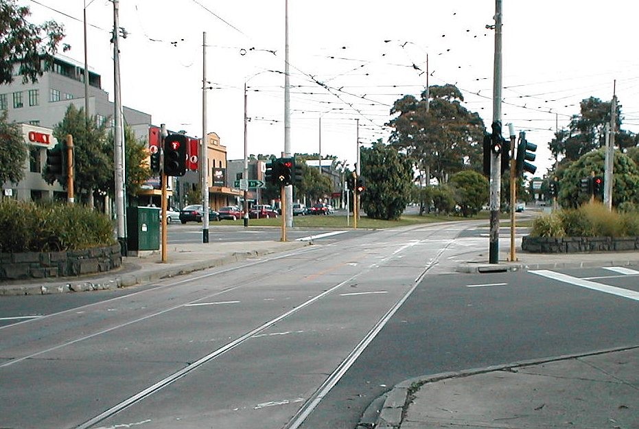
The trams were also realigned. The tramline was lowered to halfway between the first and second levels in the centre of the junction, with trams then able to reascend and continue down St Kilda Road or turn into Fitzroy Street, or descend further and turn into Queens Way. Overall, the area of junction expanded, taking in the points of intersection of all original streets, the junction now encompassing twelve streets. The tram line once diverted around the old Junction Hotel, which remained standing on its own for some time before it was eventually demolished, and the land became part of the median strip. The bridge designs for that work were undertaken by Melbourne engineer Bruce Day.
St Kilda Junction is also the location of one of Melbourne's well-loved suburban football/cricket ovals, the St Kilda Cricket Ground, which is generally known as the Junction Oval. Some of the parkland surrounding the Junction Oval was lost to the Queens Road realignment, but the original oval and the historic AboriginalCorroboree tree remained intact.
In October 2014, the St Kilda Junction Area Action Group (JaagStKilda.com) successfully lobbied VicRoads and the State Government to improve the unsafe and unfriendly pedestrian underpass, by installing improved lighting and giving the area a major clean-up. However, due to its car-centric design, significant problems remain at the junction for pedestrians, cyclists, and those using the tram and bus stops.
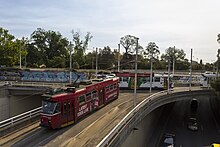
During July 2019 the tramline through the junction was shut down for rebuilding, during which the turnouts between St Kilda Rd and Fitzroy St were shifted north about 90 metres with gauntlet track for the intermediate distance. While space could not be made for a third track, as has been provided at many other junctions, the new design allows trams to travel (slightly) faster through the intersection.[3]
Trams
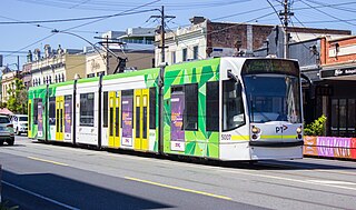
The following tram routes pass through St Kilda Junction:
St Kilda is an inner seaside suburb in Melbourne, Victoria, Australia, 6 km south-east of the Melbourne central business district, located within the City of Port Phillip local government area. St Kilda recorded a population of 19,490 at the 2021 census.
St Kilda Road is a street in Melbourne, Victoria, Australia. It is part of the locality of Melbourne which has the postcode of 3004, and along with Swanston Street forms a major spine of the city.
Melbourne tram route 6 is operated by Yarra Trams on the Melbourne tram network from Moreland to Glen Iris. The 19.2-kilometre (11.9 mi) route is operated out of Brunswick and Malvern depots with Z, B and D class trams.
Melbourne tram route 5 is a tram route on the Melbourne tramway network serving the city of Melbourne in Victoria, Australia. Operated by Yarra Trams, the route is coloured red and extends from Melbourne University to Malvern over 12.6-kilometre (7.8 mi) of double track via Swanston Street, St Kilda Road, Dandenong Road and Malvern East. It is serviced out of Malvern depot utilising Z and D1 class trams.
Melbourne tram route 96 is operated by Yarra Trams on the Melbourne tram network from East Brunswick to St Kilda Beach. The 13.9 kilometre route is operated out of Southbank and Preston depots with C2 and E class trams.
Hoddle Highway is an urban highway in Melbourne linking CityLink and the Eastern Freeway, itself a sub-section of Hoddle Main Road. Both of these names are not widely known to most drivers, as the entire allocation is still best known as by the names of its constituent parts: Hoddle Street, Punt Road and Barkly Street. This article will deal with the entire length of the corridor for sake of completion.
Chapel Street is a street in Melbourne, Victoria, running along the inner suburbs of South Yarra, Prahran, Windsor, St Kilda and St Kilda East.
Melbourne tram route 16 is a tram route on the Melbourne tramway network serving the city of Melbourne in Victoria, Australia. Operated by Yarra Trams, the route is coloured light yellow and extends from Melbourne University to Kew over 20.2 kilometre of double track via Swanston Street, St Kilda Road, Fitzroy Street, The Esplanade, Balaclava Road and Glenferrie Road. It is serviced out of Malvern depot utilising Z and D1 class trams.
Melbourne tram route 67 is operated by Yarra Trams on the Melbourne tram network from Melbourne University to Carnegie. The 12.7-kilometre (7.9 mi) route is operated out of Glenhuntly depot with Z and B class trams.
Junction Oval is a historic sports ground in the suburb of St Kilda in Melbourne, Victoria, Australia.
Glenferrie Road is a major north–south thoroughfare in Melbourne, Australia. It runs from Kew to Caulfield North, and includes major shopping districts at both Hawthorn and Malvern. There are a number of rail transport options on Glenferrie Road and also some landmarks.
Route 55 was a tram route on the Melbourne tram network. The 12.5 kilometre route operated between Coburg West and Domain Interchange, was operated out of Essendon depot with Z and B-class trams. It ceased on 30 April 2017 and was replaced by route 58.
Balaclava Junction is the only extant grand union in Australia. Located at the intersection of Balaclava Road and Hawthorn Road, Caulfield North on the Melbourne tram network, trams can go in all directions from all directions.
Melbourne tram route 3 is a tram route on the Melbourne tramway network serving the city of Melbourne in Victoria, Australia. Operated by Yarra Trams, the route is coloured light blue and extends from Melbourne University to East Malvern over 14.9-kilometre (9.3 mi) of double track via Swanston Street, St Kilda Road and Caulfield. It is serviced out of Glenhuntly depot utilising Z and B class trams. Until October 2023, route 3 operated as 3a on weekends, diverting via St Kilda Beach.
Melbourne tram route 64 is operated by Yarra Trams on the Melbourne tram network from Melbourne University to East Brighton. The 18.1 kilometre route is operated out of Glenhuntly depot with Z and B class trams.
Fitzroy Street is the major thoroughfare of the beachside Melbourne suburb of St Kilda. Its fortunes have risen and fallen along with that of St Kilda itself, from wealthy residential district to a popular working and middle class beachside entertainment district, to cheap and seedy, and popular again in the late 20th century. In recent years Fitzroy Street itself has gone from a popular restaurant strip to the situation in 2017 where only a few restaurants remain amongst kebab shops and convenience stores catering the backpackers and many empty shopfronts. It is named after Charles Augustus FitzRoy, Governor of New South Wales in 1842 when St Kilda was first subdivided.
Domain Interchange was a major interchange on the Melbourne tram system. It featured two island platforms with four tracks, and had dedicated turning tracks and through tracks. It was located on St Kilda Road between Domain Road and Park Street, adjacent to Kings Domain, and was one of the busiest interchanges on the system, being used by eight tram routes. A shelter built in 1986 was replaced when the stop was rebuilt in 2013.
Melbourne tram route 12 is operated by Yarra Trams on the Melbourne tram network from Victoria Gardens Shopping Centre to St Kilda. The 16.2-kilometre (10.1 mi) route is operated out of Southbank depot with A class trams.
The Melbourne tram network began in 1884 with the construction of the Fairfield Horse Tramway. However, the purpose of the line was to increase land prices in the area, and it soon closed during the depression in 1890. The first genuine attempt to construct a tramway network was the construction of the Richmond cable tram line by the Melbourne Tramway & Omnibus Company in 1885. Over the next few years, 16 more cable tram lines were constructed, as well as numerous other horse tramways. The depression of the early 1890s slowed further expansion of the cable network. The first electric tram line was the Box Hill and Doncaster tramway which opened in 1889. This was a pioneering line in what was then the countryside and thus didn't receive much patronage. It closed in 1896. The next attempt at an electric tramway was Victorian Railways' St Kilda to Brighton line, which opened in 1906. Later that year, the North Melbourne Electric Tramway & Lighting Company opened lines to Essendon and Maribyrnong. Many local councils formed their own tramway trusts and built tramways within their own constituency. The most successful of these was the Prahran & Malvern Tramways Trust.
This page is based on this Wikipedia article Text is available under the CC BY-SA 4.0 license; additional terms may apply. Images, videos and audio are available under their respective licenses.


