Melbourne tram route 109

Last updated

Route 109
Melbourne tram route 109 icon.svg
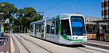
C Class Tram, Melbourne - Jan 2008.jpg
C class tram at St Vincent's Plaza
in January 2008
Overview
System Melbourne
Operator Yarra Trams
Depot Kew
Vehicle A class
C class
Began service19 December 1993
PredecessorsRoute 42, 111
Night-timeFriday & Saturday
Route
Start Box Hill
Via Whitehorse Road
Victoria Street
Collins Street
End Port Melbourne
Length19.3 kilometres
Timetable Route 109 timetable
Map Route 109 map
  Route 96  {{{system_nav}}} {{{next_line}}} 

Melbourne tram route 109 is operated by Yarra Trams on the Melbourne tram network from Box Hill to Port Melbourne. The 19.3 kilometre route is operated out of Kew depot with A and C class trams.

Contents

History

The origins of route 109 lie in separate tram lines, a cable tram from Spencer Street to the Yarra River, a horse tram from the Yarra River to Kew Cemetery, an electric line from Kew Junction to Box Hill (extended over the years), as well as the Port Melbourne railway line.

A cable line was opened by the Melbourne Tramway & Omnibus Company from Spencer Street to Brunswick Street along Collins Street, MacArthur Street, Gisborne Street and Victoria Parade on 2 October 1886, and extended to the west side of the Yarra River along Victoria Parade and Victoria Street on 22 November 1886. [1] A connecting horse tram was built from the east side of the Yarra River to Kew Cemetery, along Barkers Road, High Street South and High Street, opening on 28 December 1887.

The Prahran & Malvern Tramways Trust (PMTT) opened a line from High Street to Burke Road along Cotham Road on 30 May 1913. On 1 November 1914 the PMTT received permission to convert the horse tram line to electric traction, and the new electric line was opened on 24 February 1915. The PMTT extended the Cotham Road line to Union Road, Mont Albert along Whitehorse Road, on 30 September 1916. [2] [3]

In 1929 the Melbourne & Metropolitan Tramways Board (MMTB) started converting the Collins Street cable lines to electric traction, with the last cable tram running down Collins Street on 14 September 1929, and the first electric tram on 8 December 1929. At the same time the MMTB built a new electric line down the centre of Victoria Parade to replace the cable line, which opened on 15 September 1929. [4] For the next six decades the Melbourne to Mont Albert tram was numbered 42, celebrated by a 1982 theatrical production, Storming Mont Albert by Tram, which was performed on a specially-chartered Route 42 tram from the Mont Albert terminus to the city and return. [5]

On 21 December 1987, route 111 commenced running from Exhibition (Carlton Gardens) at Nicholson Street to Port Melbourne along Bourke Street, Spencer Street and the former Port Melbourne railway line, following the conversion of the railway (along with the St Kilda line) to light rail. [6] [7] [8] The broad gauge 1,600 mm (5 ft 3 in) track was re-gauged to standard gauge 1,435 mm (4 ft 8+12 in) and the overhead voltage was reduced from 1500 V DC to 600 V DC with light rail platforms built adjacent to or near the former stations platforms.

On 19 December 1993, routes 42 and 111 were combined as route 109. [9] [10] [11] Route 42 continued to run as a peak-hour variant of route 109, and from 18 November 2002, the route deviated from route 109 and ran between Box Hill and the Collins Street West extension in Docklands. [12] From 28 June 2004 until 21 November 2005, the route was truncated back to Spencer Street while Spencer Street station (now Southern Cross station) was redeveloped. [13] It was extended further along the Collins Street extension to Victoria Harbour (Merchant Street) on 21 September 2009. [14] [6] At this point, the route ran one morning trip and three afternoon trips from Box Hill to Victoria Harbour and then back to Box Hill. [15] Route 42 was last listed as an official route in late 2010 / early 2011 before it gradually disappeared without an official announcement. [16]

When Station Pier was refurbished in 1999, tram tracks were laid to allow for route 109 to be extended onto the pier, but have never been connected. [17]

The line was extended from its original terminus at Mont Albert to Box Hill along Whitehorse Road for 2.2 kilometres on 2 May 2003. [18] [19] [20] In January 2016, route 109 began operating through the night on Fridays and Saturdays as part of the Night Network. [21]

Route

The Port Melbourne terminus, with the Port Melbourne railway station building in the foreground Melbourne Tram Route (109) at Station Pier.jpg
The Port Melbourne terminus, with the Port Melbourne railway station building in the foreground

Route 109 runs from Box Hill, travelling west on Whitehorse Road through the suburbs of Mont Albert, Surrey Hills, Balwyn and Deepdene. Entering Kew at Burke Road, Whitehorse Road becomes Cotham Road. It continues west, through Kew Junction and then south west along High Street, High Street South and turns west into Barkers Road.

It crosses the Yarra River into Victoria Street, Richmond and continues west, at Hoddle Street Victoria Street becomes Victoria Parade, it passes through St Vincent's Plaza, passing St Vincent's Hospital, the Royal Victorian Eye and Ear Hospital and turns south onto Gisborne Street, continues south west along MacArthur Street and turns west into Collins Street, entering the CBD, passing Melbourne Town Hall and City Square.

It turns south into Spencer Street, passing Southern Cross station, then crosses the Yarra River and enters Southbank on Clarendon Street before traversing the suburbs of South Melbourne and Port Melbourne on a right-of-way using the former Port Melbourne railway line and terminates at Port Melbourne railway station near Station Pier.

Operation

Route 109 is operated out of Kew depot with A and C1 class trams. [22] For a period from 2002, some services were also operated by Southbank depot. [23] [24]

Route map

Route 109
Box Hill - Port Melbourne
via Mont Albert, City & Southbank
Free tram zone covers stops 124 to 8, fare zone 1 from
stop 57 to 10, 124A to 129, fare zone 2 from stop 57 to 47
Suburb
Street
Stop
No.
Box Hill
Connections
58
BSicon exBLq.svg
BSicon uKACCa.svg
BSicon exBLq.svg
Box Hill Central
BSicon uSTR.svg
Aiga railtransportation 25.svg Box Hill station
57
BSicon uACC.svg
Nelson Road
56
BSicon uACC.svg
Elgar Road
55
BSicon exBLq.svg
BSicon uACC.svg
BSicon exBLq.svg
Hood Street
54
BSicon uACC.svg
Inglisby Road
53
BSicon exBLq.svg
BSicon uHST.svg
BSicon exBLq.svg
Union Road
Bus-logo.svg 284, 612
51
BSicon uHST.svg
Narrak Road
50
BSicon uHST.svg
Wharton Street
49
BSicon exBLq.svg
BSicon uHST.svg
BSicon exBLq.svg
Northcote Avenue
48
BSicon uHST.svg
Balwyn Shopping Centre
47
BSicon uHST.svg
Balwyn Road
Bus-logo.svg 285
Zone 1+2
Zone 1
BSicon uSTR+GRZq.svg
46
BSicon uHST.svg
Balwyn Cinema
45
BSicon uHST.svg
Hardwicke Street
44
BSicon exBLq.svg
BSicon uHST.svg
BSicon exBLq.svg
Deepdene Park
43
BSicon uHST.svg
Deepdene Shopping Centre
42
BSicon uHST.svg
Burke Road
BSicon TRAM.svg 72; Bus-logo.svg 548
BSicon lENDE@Fq.svg
BSicon uSTR.svg
BSicon uCONTfq.svg
Burke Road
Tram 72
Kew
Cotham Road
41
BSicon exBLq.svg
BSicon uHST.svg
BSicon exBLq.svg
Kew Traffic School
40
BSicon uHST.svg
St George's Hospital
Bus-logo.svg 548
39
BSicon uHST.svg
Thomas Street
38
BSicon uHST.svg
Marshall Avenue
37
BSicon uHST.svg
Belmont Avenue
36
BSicon uHST.svg
Glenferrie Road
BSicon TRAM.svg 16
BSicon uABZg+l.svg
BSicon uCONTfq.svg
Glenferrie Road
Tram 16
35
BSicon uHST.svg
Charles Street
Bus-logo.svg 609
34
BSicon uHST.svg
High Street
BSicon uCONTgq.svg
BSicon uABZg+r.svg
High Street
Tram 48
Kew
High Street
33
BSicon uHST.svg
Cotham Road
BSicon TRAM.svg 48
32
BSicon uHST.svg
Kew Junction
Bus-logo.svg 200, 207, 609
31
BSicon uHST.svg
Stevenson Street
BSicon uKRW+l.svg
BSicon uKRWgr.svg
BSicon uSTR.svg
BSicon uABZgl.svg
BSicon uCONTfq.svg
Church Street
Tram 48
Hawthorn
Barkers Road
29
BSicon uSTR.svg
BSicon exBLq.svg
BSicon uHST.svg
BSicon exBLq.svg
High Street
BSicon TRAM.svg 48
BSicon uDST.svg
BSicon uSTR.svg
Kew tram depot
BSicon uKRWl.svg
BSicon uKRWg+r.svg
27
BSicon uHST.svg
Findon Crescent
25
BSicon exBLq.svg
BSicon uACC.svg
BSicon exBLq.svg
River Boulevard
BSicon lvENDE@G-.svg
BSicon uv-SHI2g+r.svg
Victoria Gardens Siding
24
BSicon uACC.svg
Victoria Gardens
BSicon TRAM.svg 12
23
BSicon uHST.svg
Leslie Street
22
BSicon uHST.svg
McKay Street
21
BSicon uHST.svg
Church Street
BSicon TRAM.svg 78
BSicon uABZgl.svg
BSicon uCONTfq.svg
Church Street
Tram 78
 
  Balaclava Arrow Blue Right 001.svg
20
BSicon uACC.svg
Lennox Street
19
BSicon uACC.svg
North Richmond station
BSicon CONTgq.svg
BSicon umKRZu.svg
BSicon lvACC-.svg
BSicon CONTf@Fq.svg
Aiga railtransportation 25.svg North Richmond station
18
BSicon exBLq.svg
BSicon uACC.svg
BSicon exBLq.svg
Hoddle Street
16
BSicon uACC.svg
Wellington Street
15
BSicon uACC.svg
Smith Street
13
BSicon ldENDE@F.svg
BSicon udACC.svg
Lansdowne Street
BSicon uv-SHI2g+r.svg
St Vincent's Plaza Siding
BSicon uCONTgq.svg
BSicon uABZg+r.svg
Brunswick Street
Tram 11
12
BSicon exBLq.svg
BSicon uACC.svg
BSicon exBLq.svg
St Vincent's Plaza
BSicon uCONTgq.svg
BSicon uABZgr.svg
Victoria Parade
Tram 30
 
Gisborne Street
11
BSicon uBHF.svg
Albert Street
 
Macarthur Street
10
BSicon uACC.svg
Parliament station
BSicon lv-ACC.svg
BSicon tCONTg@Gq.svg
BSicon umKRZt.svg
BSicon tCONTf@Fq.svg
Aiga railtransportation 25.svg Parliament Station
BSicon uCONTgq.svg
BSicon uKRZ+l.svg
BSicon uCONTfq.svg
Spring Street
Tram 48, City Circle
Wellington ParadeArrow Blue Right 001.svg
 Arrow Blue Left 001.svg Nicholson Street
8
BSicon exBLq.svg
BSicon uACC.svg
BSicon exBLq.svg
Spring Street
7
BSicon uACC.svg
101 Collins Street
Bus-logo.svg 605
BSicon uCONTgq.svg
BSicon uKRZ.svg
BSicon uCONTfq.svg
Swanston Street
Tram 1, 3, 5, 6, 16, 64, 67, 72
6
BSicon uACC.svg
Town Hall
BSicon TRAM.svg 1, 3, 5, 6, 16, 64, 67, 72
BSicon uCONTgq.svg
BSicon uKRZ.svg
BSicon uCONTfq.svg
Elizabeth Street
Tram 19, 57, 59
5
BSicon uACC.svg
Elizabeth Street
BSicon TRAM.svg 19, 57, 59
3
BSicon uACC.svg
William Street
BSicon uCONTgq.svg
BSicon uKRZ.svg
BSicon uCONTfq.svg
William Street
Tram 58
1
BSicon uACC.svg
Southern Cross station
BSicon TRAM.svg 11, 48, 96
BSicon uSTR.svg
Aiga railtransportation 25.svg Southern Cross station
BSicon uCONTg.svg
BSicon uSTR.svg
Spencer Street
Tram 96
BSicon uCONTg@Gq.svg
BSicon uKRWl.svg
BSicon uABZgr.svg
BSicon uKRWg+r.svg
Collins Street
Tram 11, 48
 
 Arrow Blue Left 001.svg Docklands
BSicon uCONTgq.svg
BSicon uKRZl.svg
BSicon uCONTfq.svg
Flinders Street
Tram 70, 75, City Circle
BSicon CONTgq.svg
BSicon umKRZu.svg
BSicon CONTfq.svg
Flinders Street Viaduct
 
Spencer Street
124
BSicon uACC.svg
Batman Park
Southbank
Clarendon Street
124A
BSicon exBLq.svg
BSicon uACC.svg
BSicon exBLq.svg
Casino/MCEC
BSicon TRAM.svg 12
BSicon uABZgl.svg
BSicon uCONTfq.svg
Clarendon Street
Tram 12
 
Normanby Road
125
BSicon uACC.svg
Clarendon Street Junction
BSicon TRAM.svg 96
BSicon uABZgl.svg
BSicon uCONTfq.svg
St Kilda Light Rail
Tram 96
South Melbourne
Normanby Road
125A
BSicon exBLq.svg
BSicon uACC.svg
BSicon exBLq.svg
Southbank tram depot
BSicon uKDSTaq.svg
BSicon uABZgr+r.svg
Southbank tram depot
126
BSicon uACC.svg
Montague Street
Port Melbourne
Station Street
127
BSicon exBLq.svg
BSicon uACC.svg
BSicon exBLq.svg
North Port
128
BSicon uACC.svg
Graham Street
129
BSicon uKACCe.svg
Beacon Cove
Bus-logo.svg 236, PPC
Suburb
No.
Stop Name (Road Name)
Connections
Note: Green denotes free tram zone

Bus route

When cruise ships are berthed at Station Pier, Transit Systems Victoria operate a parallel bus service as route 109 between Station Pier and the Arts Centre. [25]

Related Research Articles

<span class="mw-page-title-main">Surrey Hills, Victoria</span> Suburb of Melbourne, Victoria, Australia

Surrey Hills is a suburb of Melbourne, Victoria, Australia, 11 km east of Melbourne's Central Business District, located within the Cities of Boroondara and Whitehorse local government areas. Surrey Hills recorded a population of 13,655 at the 2021 census.

<span class="mw-page-title-main">Mont Albert, Victoria</span> Suburb of Melbourne, Victoria, Australia

Mont Albert is an inner eastern suburb of Melbourne, Victoria, Australia, 12 kilometres east of Melbourne's Central Business District, located within the Cities of Boroondara and Whitehorse local government areas. Mont Albert recorded a population of 4,948 at the 2021 census.

<span class="mw-page-title-main">Balwyn</span> Suburb of Melbourne, Victoria, Australia

Balwyn is a suburb of Melbourne, Victoria, Australia, 10 km east of Melbourne's Central Business District, located within the City of Boroondara local government area. Balwyn recorded a population of 13,495 at the 2021 census.
<span class="mw-page-title-main">Melbourne tram route 6</span>

Melbourne tram route 6 is operated by Yarra Trams on the Melbourne tram network from Moreland to Glen Iris. The 19.2-kilometre (11.9 mi) route is operated out of Brunswick and Malvern depots with Z, B and D class trams.
<span class="mw-page-title-main">Melbourne tram route 5</span>

Melbourne tram route 5 is operated by Yarra Trams on the Melbourne tram network from Melbourne University to Malvern. The 12.6-kilometre (7.8 mi) route is operated out of Malvern depot with Z and D1 class trams.

<span class="mw-page-title-main">Melbourne tram route 112</span>

Melbourne tram route 112 was operated by Yarra Trams on the Melbourne tram network from West Preston to St Kilda. The 18 kilometre route was operated out of East Preston depot with A, B and D2 class trams.

<span class="mw-page-title-main">Melbourne tram route 96</span>

Melbourne tram route 96 is operated by Yarra Trams on the Melbourne tram network from Brunswick East to St Kilda Beach. The 13.9 kilometre route is operated out of Southbank depot with C2, E class, and on occasion A class trams.

<span class="mw-page-title-main">Melbourne tram route 75</span> Tram route in metropolitan Melbourne, Victoria, Australia

Melbourne tram route 75 is operated by Yarra Trams on the Melbourne tram network from Vermont South to Central Pier. The 22.8 kilometre route is operated out of Camberwell depot with A and B class trams. It is the longest route on the network.

<span class="mw-page-title-main">Melbourne tram route 70</span> Yarra Trams service

Melbourne tram route 70 is operated by Yarra Trams on the Melbourne tram network from Waterfront City to Wattle Park. The 16.5 kilometre route is operated out of Camberwell depot with A and B class trams.

<span class="mw-page-title-main">Melbourne tram route 16</span> Tram route in metropolitan Melbourne, Victoria, Australia

Melbourne tram route 16 is operated by Yarra Trams on the Melbourne tram network from Melbourne University to Kew. The 20.2 kilometre route is operated out of Malvern depot with Z and D1 class trams.

<span class="mw-page-title-main">Melbourne cable tramway system</span> Cable car public transport system in Melbourne, Australia

The Melbourne cable tramway system was a cable car public transport system, which operated between 1885 and 1940 in Melbourne, Victoria, Australia.

<span class="mw-page-title-main">A-class Melbourne tram</span>

The A-class Melbourne tram is a class of bogie trams that operate on the Melbourne tram network. Seventy were built by Comeng, Dandenong between 1984 and 1987 in two batches, 28 A1s and 42 A2s, with only minor differences. They are the smallest trams by capacity currently operating on the network.

<span class="mw-page-title-main">Southbank tram depot</span>

Southbank tram depot is located in Southbank, a suburb of Melbourne, Australia. Operated by Yarra Trams, it is one of eight tram depots on the Melbourne tram network.

<span class="mw-page-title-main">Melbourne tram route 86</span> Tram route in Melbourne, Victoria, Australia

Melbourne tram route 86 is operated by Yarra Trams on the Melbourne tram network from Bundoora RMIT to Waterfront City. The 22.2-kilometre (13.8 mi) route is operated out of Preston depot with E class trams.
<span class="mw-page-title-main">Melbourne tram route 30</span> Tram route in Melbourne, Victoria, Australia

Melbourne tram route 30 is operated by Yarra Trams on the Melbourne tram network from St Vincent's Plaza to Central Pier. The 2.9-kilometre (1.8 mi) route is operated out of Southbank depot with A and E class trams.
<span class="mw-page-title-main">Melbourne tram route 31</span>

Melbourne tram route 31 was operated by Yarra Trams on the Melbourne tram network from Hoddle Street to Victoria Harbour. The route was designed as a supplementary service along Collins Street, with services running between peak hours with reduced services on weekends.

<span class="mw-page-title-main">Melbourne tram route 48</span>

Melbourne tram route 48 is operated by Yarra Trams on the Melbourne tram network from Balwyn North to Victoria Harbour. The 13.5-kilometre (8.4 mi) route is operated out of Kew depot with A and C class trams.

<span class="mw-page-title-main">Melbourne tram route 11</span>

Melbourne tram route 11 is operated by Yarra Trams on the Melbourne tram network from West Preston to Victoria Harbour. The 13.4-kilometre (8.3 mi) route is operated out of Preston depot with E class trams.

Numerous proposals have been made for improvements to the Melbourne tram network, the largest such network in the world. Nearly all of these have been for track extensions of existing lines to connect with nearby railway station or to service new areas and suburbs.

The Melbourne tram network began in 1884 with the construction of the Fairfield Horse Tramway. However, the purpose of the line was to increase land prices in the area, and it soon closed during the depression in 1890. The first genuine attempt to construct a tramway network was the construction of the Richmond cable tram line by the Melbourne Tramway & Omnibus Company in 1885. Over the next few years, 16 more cable tram lines were constructed, as well as numerous other horse tramways. The depression of the early 1890s slowed further expansion of the cable network. The first electric tram line was the Box Hill and Doncaster tramway which opened in 1889. This was a pioneering line in what was then the countryside and thus didn't receive much patronage. It closed in 1896. The next attempt at an electric tramway was Victorian Railways' St Kilda to Brighton line, which opened in 1906. Later that year, the North Melbourne Electric Tramway & Lighting Company opened lines to Essendon and Maribyrnong. Many local councils formed their own tramway trusts and built tramways within their own constituency. The most successful of these was the Prahran & Malvern Tramways Trust.
References

  1. Melbourne Tramway & Omnibus Company Limited Running Journal volume 9 no 3 page 16
  2. Milestones, 1911 - 1920 Yarra Trams
  3. History of the Mont Albert Tramway Transit Australia June 2003 pages 154-159
  4. Milestones, 1921 - 1930 Yarra Trams
  5. Storming Mont Albert by Tram - Melbourne Moomba Festival Theatre Works: St Kilda
  6. 1 2 "History of Melbourne Tram Routes from 1950 to 2009" (PDF). Yarra Trams. Archived from the original (PDF) on 19 March 2012.
  7. Jones, Colin (1993). Watch for Trams. Kenthurst: Kangaroo Press. p. 118. ISBN   0-86417-544-2.
  8. Milestones, 1981 - 1990 Yarra Trams
  9. The Met Fleetline issue 221 December 1993 page 264
  10. National Bus Company Australian Bus Panorama issue 9/5 January 1994 page 31
  11. Melbourne News Trolley Wire issue 256 February 1994 page 23
  12. "Timetable Changes to Collins Street Services". Yarra Trams. 29 November 2002. Archived from the original on 6 December 2002.
  13. Temporary Closure of Collins Street Extension Yarra Trams
  14. Changes to Routes 48 & 70 from Sunday 20 September 2009 Yarra Trams
  15. "Route 42 timetable" (PDF). Metlink. 20 September 2009. Archived from the original (PDF) on 7 October 2009.
  16. "42 - Box Hill - Victoria Harbour Docklands". Metlink. Archived from the original on 26 February 2011.
  17. Station Pier Tramway Extension Transit Australia February 2002 pages 54/55
  18. Box Hill Extension Opening Yarra Trams 2 May 2003
  19. Mont Albert - Box Hill Tramway Extension Opens Transit Australia July 2003 pages 179-186
  20. Mont Albert - Box Hill tram extension opened Railway Digest June 2003 page 11
  21. Night Tram Public Transport Victoria
  22. Kew Depot Vicsig
  23. Kew Depot Transit Australia October 2002 page 274
  24. Melbourne's longest routes The Bellcord issue 52 December 2021 page 4
  25. 109 Express Port Melbourne to Arts Centre Public Transport Victoria