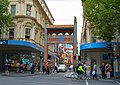
Swanston Street

Last updated

Swanston Street

Swanston Street.jpg
Swanston Street near City Square
Swanston Street
Australia Victoria metropolitan Melbourne location map.svg
Red pog.svg
Swanston Street
Coordinates
General information
TypeStreet
Length2.8 km (1.7 mi)
Opened1837
Route number(s) Australian state route 34.svg Metro Route 34 (1965–present)
(through Parkville)
Former
route number
Australian state route 3.svg Metro Route 3 (1965–1989)
(through Melbourne)
Major junctions
North endAustralian state route 83.svg College Crescent
Australian state route 83.svg Cemetery Road East
Parkville, Melbourne
 
South endAustralian state route 3.svg St Kilda Road
Melbourne CBD
Location(s)
LGA(s) City of Melbourne
Suburb(s) Parkville, Carlton, Melbourne CBD

Swanston Street is a major thoroughfare in the Melbourne central business district, Victoria, Australia. It was laid out in 1837 as part of the original Hoddle Grid. The street vertically bisects Melbourne's city centre and is famous as the world's busiest tram corridor, for its heritage buildings and as a shopping strip. [1]

Contents

Swanston Street runs roughly north–south in-between Russell Street to the east and Elizabeth Street to the west. To the south it becomes St Kilda Road after the intersection with Flinders Street, whilst the road's northern end is in the suburb of Carlton at Melbourne Cemetery. This northern section was originally named Madeline Street. [2] The street is named after merchant, banker and politician Charles Swanston.

History

Swanston Street was one of the main north–south streets originally laid out as part of the 1837 Hoddle Grid. Originally carrying pedestrians and horse-drawn traffic, the street resembled many typical European avenues of the 19th century. By the end of the 19th century it also accommodated one of the major tram lines through the city. With the advent of the automobile in the early 20th century, the street became a major thoroughfare, carrying car traffic between areas north of the city and St Kilda Road throughout most of the 20th century.

In the latter half of the 20th century, the southern half of the street had problems with heavy traffic and its associated pollution, homelessness, loitering, and a plethora of discount stores, fast food outlets, sex shops and strip joints.

As part of Victoria's 150th birthday celebrations, Swanston Street was closed to traffic, turfed and treed between Flinders Street and Lonsdale Street for a Summer street-party on February 9-10, 1985. [3] [4] The conversation then began around the permanent transformation of Swanston Street. In March 1992, the street was closed to daytime private through-traffic between Flinders and La Trobe Streets, roughly half its length. [5] This section is known as Swanston Street Walk. Swanston Street was redeveloped in 1992 with a number of public sculptures being established through the Percent for Art Program. The most famous of these statues is of a small bronze dog called Larry La Trobe by Melbourne artist, Pamela Irving. By the turn of the 21st century, the street carried nine tram routes, with the frequency of trams being the highest in Melbourne.

In November 2008, the newly elected Lord Mayor of Melbourne Robert Doyle proposed returning private vehicle traffic to the street. [6] The move attracted opposition from the Public Transport Users Association, Australian Greens and Bicycle Victoria. The idea was rejected and, by January 2010, plans to make the entire length of Swanston Street in the city car-free were announced by the Lord Mayor himself, a complete reversal of his previous stance. [7]

Use for marches, rallies and protests

Many marches, rallies and protests involve the use of Swanston Street, resulting in planned and unplanned road closures. The street is the venue for many annual events, including the Moomba parade, the AFL Grand Final parade and Melbourne Cup parade. It is also the major route for the Anzac Day parade because Swanston Street leads into St Kilda Road, the site of the Shrine of Remembrance.

Becoming car free

Swanston Street was one of the busiest roads in Melbourne, carrying a large volume of private car traffic, mostly transiting through the city. In 1992, the street was made partially car-free, with limited exemptions for small freight, buses and private cars during certain times of the day. After that, proposals for the street to become entirely car-free gained momentum.

On 27 January 2010, it was announced that the entire length of Swanston Street would become car free. [7] The $25.6 million proposal included plans for several city squares along the street and several large tram stops. Aside from trams, the only motorised vehicular access was for emergency vehicles and small-scale freight at certain times. The modifications to the street commenced in late 2011 and were completed in late 2012.

Notable buildings

Flinders Street station Flinders Street Station Main Building, May 2019.jpg
Flinders Street station
The Chinatown Archway on Swanston Street Gate to Melbourne Chinatown.jpg
The Chinatown Archway on Swanston Street

Many of Melbourne's most noteworthy precincts and prominent buildings face Swanston Street as the city's historic main avenue, including:

Both the University of Melbourne and RMIT University also have campus buildings fronting Swanston Street.

Transport

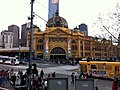
Tram routes 1, 3, 5, 6, 16, 64, 67 and 72 currently run along the street, with the frequency of trams making Swanston Street the world's busiest tram corridor. [1] Two of the busiest railway stations in Melbourne are located near the street, with the hub Flinders Street station at its southern end and, further north, the underground Melbourne Central station at the intersection of La Trobe Street. The Metro Tunnel is being constructed under Swanston Street, and should be completed in 2025.

Swanston Street is also a major route for commuting cyclists to and through the city, with bike lanes from the northern suburbs and from St Kilda Road in the south, and the Capital City Trail on the Southbank of the Yarra River.

The parking of tour buses along the street caused controversy in September 2008 when a young cyclist was killed by a bus as it turned out of a parking spot. [8] There had previously been calls to the council to relocate the large buses from the street where there was little space between buses and trams.

Swanston Street was previously served by bus services to Gardenvale and Middle Brighton. When Melbourne-Brighton Bus Lines' licence periodically came up for review, the Melbourne City Council and Melbourne & Metropolitan Tramways Board always opposed. [9] [10] [11] Finally the buses were removed from Swanston Street in October 1989, by which time they were operated by the Public Transport Corporation. [12]

Swanston Street was the shooting location for the 1976 video for AC/DC's song "It's a Long Way to the Top (If You Wanna Rock 'n' Roll)". It led to a nearby street being renamed ACDC Lane in honour of the music video.

It is also referenced in The Distillers' song "Dismantle Me", as singer Brody Dalle is originally from Melbourne, as well as TISM's song "Get Thee in My Behind Satan" and Courtney Barnett's "Elevator Operator".

Jane Halifax (Rebecca Gibney) of the Halifax f.p. television series is shown living in an apartment at 339 Swanston Street (Jensen House; [13] now converted into a UniLodge) opposite the State Library.

See also

Australia road sign W5-29.svg   Australian roadsportal

Related Research Articles

<span class="mw-page-title-main">Timeline of Melbourne history</span>

The following is a timeline of the history of the city of Melbourne, Victoria, Australia.

<span class="mw-page-title-main">Bundoora</span> Suburb of Melbourne, Victoria, Australia

Bundoora is a suburb in Melbourne, Victoria, Australia, 15 km (9.3 mi) north-east of Melbourne's Central Business District, located within the Cities of Banyule, Darebin and Whittlesea local government areas. Bundoora recorded a population of 28,068 at the 2021 census.

<span class="mw-page-title-main">North Richmond railway station</span> Railway station in Richmond, Australia

North Richmond railway station is located on the Mernda and Hurstbridge lines in Victoria, Australia. It serves the inner eastern Melbourne suburb of Richmond, and opened on 21 October 1901.

<span class="mw-page-title-main">Bourke Street</span> Street in Melbourne, Australia

Bourke Street is one of the main streets in the Melbourne central business district and a core feature of the Hoddle Grid. It was traditionally the entertainment hub of inner-city Melbourne, and is now also a popular tourist destination and tram thoroughfare.

<span class="mw-page-title-main">St Kilda Road</span> Road in Melbourne, Victoria, Australia

St Kilda Road is a street in Melbourne, Victoria, Australia. It is part of the locality of Melbourne which has the postcode of 3004, and along with Swanston Street forms a major spine of the city.

<span class="mw-page-title-main">Melbourne Central railway station</span> Train Station in Victoria, Australia

Melbourne Central railway station is an underground station on the electrified railway network in Melbourne, Australia. It is one of three underground stations on the City Loop, which runs through the north and east of the Melbourne CBD.

<span class="mw-page-title-main">Melbourne tram route 96</span>

Melbourne tram route 96 is operated by Yarra Trams on the Melbourne tram network from Brunswick East to St Kilda Beach. The 13.9 kilometre route is operated out of Southbank depot with C2, E class, and on occasion A class trams.

<span class="mw-page-title-main">Elizabeth Street, Melbourne</span> Road in Melbourne, Victoria

Elizabeth Street is one of the main streets in the Melbourne central business district, Victoria, Australia, part of the Hoddle Grid laid out in 1837. It is presumed to have been named in honour of governor Richard Bourke's wife.

<span class="mw-page-title-main">Russell Street, Melbourne</span> Street in Melbourne, Victoria

Russell Street is a main street and thoroughfare in the Melbourne central business district, Victoria, Australia. It runs roughly north-south and was laid out as a core feature of the Hoddle Grid in 1837.

<span class="mw-page-title-main">Victoria Street, Melbourne</span> Road in Melbourne, Victoria

Victoria Street is one of the major thoroughfares of inner Melbourne, running east–west for over six kilometres between Munster Terrace in North Melbourne and the Yarra River. The road is known as Victoria Parade for over one-and-a-half kilometres of its length, distinguishable with a wide reservation and tramway down the middle.

<span class="mw-page-title-main">Melbourne cable tramway system</span> Cable car public transport system in Melbourne, Australia

The Melbourne cable tramway system was a cable car public transport system, which operated between 1885 and 1940 in Melbourne, Victoria, Australia.

<span class="mw-page-title-main">Transport in Melbourne</span> Overview of transport in Melbourne, Victoria, Australia

Transport in Melbourne, the state capital of Victoria, Australia, consists of several interlinking modes. Melbourne is a hub for intercity, intracity and regional travel. Road-based transport accounts for most trips across many parts of the city, facilitated by Australia's largest freeway network. Public transport, including the world's largest tram network, trains and buses, also forms a key part of the transport system. Other dominant modes include walking, cycling and commercial-passenger vehicle services such as taxis.

<span class="mw-page-title-main">Melbourne tram route 1</span>

Melbourne tram route 1 is operated by Yarra Trams on the Melbourne tram network from East Coburg to South Melbourne Beach. The 13.2-kilometre (8.2 mi) route is operated out of Brunswick depot with Z and B class trams.

<span class="mw-page-title-main">Melbourne tram route 86</span> Tram route in Melbourne, Victoria, Australia

Melbourne tram route 86 is operated by Yarra Trams on the Melbourne tram network from Bundoora RMIT to Waterfront City. The 22.2-kilometre (13.8 mi) route is operated out of Preston depot with E class trams.

<span class="mw-page-title-main">Princes Bridge</span> Bridge across the Yarra River in Melbourne, Australia

Princes Bridge, originally Prince's Bridge, is a bridge in central Melbourne, Australia that spans the Yarra River. It is built on the site of one of the oldest river crossings in the city, and forms a gateway into the central city from the south. The bridge connects Swanston Street on the north bank of the Yarra River to St Kilda Road on the south bank, and carries road, tram and pedestrian traffic. The present bridge was built in 1888 and is listed on the Victorian Heritage Register.

<span class="mw-page-title-main">Melbourne central business district</span> Central business district of Melbourne, Victoria, Australia

The Melbourne central business district is the city centre and main urban area of the city of Melbourne, Victoria, Australia, centred on the Hoddle Grid, the oldest part of the city laid out in 1837, and includes its fringes. The Melbourne CBD is located in the local government area of the City of Melbourne which also includes some of inner suburbs adjoining the CBD.

<span class="mw-page-title-main">Metro Tunnel</span> Underground rapid transit project in Melbourne, Australia

The Metro Tunnel is a metropolitan heavy rail project currently under construction in Melbourne, Victoria, Australia. It includes the construction of twin 9-kilometre (5.6 mi) rail tunnels between South Kensington and South Yarra with five new underground stations. The tunnel will connect the Pakenham and Cranbourne lines with the Sunbury line, creating a new high-frequency cross-city line that bypasses Flinders Street station and the City Loop. The line is also planned to serve Melbourne Airport via a new branch line west of Sunshine.

<span class="mw-page-title-main">Melbourne tram route 12</span> Tram route in metropolitan Melbourne, Victoria, Australia

Melbourne tram route 12 is operated by Yarra Trams on the Melbourne tram network from Victoria Gardens Shopping Centre to St Kilda. The 16.2-kilometre (10.1 mi) is operated out of Southbank depot with A class trams.

The Melbourne tram network began in 1884 with the construction of the Fairfield Horse Tramway. However, the purpose of the line was to increase land prices in the area, and it soon closed during the depression in 1890. The first genuine attempt to construct a tramway network was the construction of the Richmond cable tram line by the Melbourne Tramway & Omnibus Company in 1885. Over the next few years, 16 more cable tram lines were constructed, as well as numerous other horse tramways. The depression of the early 1890s slowed further expansion of the cable network. The first electric tram line was the Box Hill and Doncaster tramway which opened in 1889. This was a pioneering line in what was then the countryside and thus didn't receive much patronage. It closed in 1896. The next attempt at an electric tramway was Victorian Railways' St Kilda to Brighton line, which opened in 1906. Later that year, the North Melbourne Electric Tramway & Lighting Company opened lines to Essendon and Maribyrnong. Many local councils formed their own tramway trusts and built tramways within their own constituency. The most successful of these was the Prahran & Malvern Tramways Trust.

<span class="mw-page-title-main">Outline of Melbourne</span> Overview of and topical guide to the city of Melbourne, in Australia

The following outline is provided as an overview of and topical guide to Melbourne:

References

  1. 1 2 Carey, Adam (30 May 2015). "Melbourne to be split in two as Swanston Street is torn up". The Age. Retrieved 22 October 2016.
  2. "GENERAL NEWS". The Age. 3 March 1925. p. 10. Retrieved 6 June 2016.
  3. "Swanston Street Summer Party [picture] : Melbourne, 9 & 10 February, 1985".
  4. "Imagine a City: Swanston Street Party and the greening of Melbourne". 8 September 2016.
  5. Melbourne Trams Services Trolley Wire issue 249 May 1992 page 25
  6. Lucas, Clay (2 December 2008). "New mayor driving down a wrong-way street". The Age . Archived from the original on 3 December 2008. Retrieved 6 June 2016.{{cite web}}: CS1 maint: unfit URL (link)
  7. 1 2 Dowling, Jason (27 January 2010). "No cars, new city squares: Doyle's Swanston Street reversal". The Age. Retrieved 6 August 2010.
  8. "Herald Sun | Breaking News and Headlines from Melbourne and Victoria | Herald Sun".
  9. Private Buses to Stay in Swanston Street Truck & Bus Transportation January 1953 page 5
  10. Swanston St Buses to Stay: Licences Increased to 7 yrs Truck & Bus Transportation June 1956 page 59
  11. Licence renewal Truck & Bus Transportation July 1970 page 34
  12. Buses out of Swanston Street Fleetline issue 174 January 1990 page 12
  13. "Barlow Jensen House - Swanston Street. MELBOURNE [Walking Melbourne Building Information]". walkingmelbourne.com. Retrieved 15 August 2020.

Commons-logo.svg Media related to Swanston Street at Wikimedia Commons