Station Pier

Last updated

Road entrance to Station Pier. Station Pier entrance Port Melbourne 2012-10-10.jpg
Road entrance to Station Pier.

Station Pier is a historic Australian pier on Port Phillip, in Port Melbourne, Victoria. Opened in 1854, the pier is Melbourne's primary passenger terminal, servicing interstate ferries and cruise ships, and is listed on the Victorian Heritage Register.

Contents

History

Railway Pier in the late-1800s. The Railway Pier, Sandridge, Melbourne, Victoria ca. 1878-79 (9445632207).jpg
Railway Pier in the late-1800s.

Station Pier, originally known as Railway Pier, was officially opened on 12 September 1854. [1] The 4.5 kilometre Port Melbourne line from the pier to Flinders Street station via the Sandridge Bridge was opened at the same time to facilitate the transport of passengers and goods, and was the first significant railway in Australia. [2] The pier was kept busy throughout the 1850s, due to the increased passenger traffic created by the gold rush. In 1861, the pier was extended to a length of 661 metres, in order to accommodate the ever-increasing traffic associated with the number of people settling in Victoria. [1]

HMS King George V Battleship docked at Station Pier in 1945. Station pier melbourne.jpg
HMS King George V Battleship docked at Station Pier in 1945.

In the early part of the 20th century, the original pier was unable to accommodate the new breed of larger and more powerful steamships. As a result, the current pier was built between 1922 and 1930 and is the largest timber piled wharf structure in Australia. The Stothert and Pitt cranes were erected in 1949 for goods handling. [3] The original supports are still underneath the current pier, chopped down when the replacement was built. The new pier was designed so that passengers landed at the terminals above, while goods traffic moved underneath, in what was quite forward thinking for the 1920s. [4] It has a wharf length of 933 metres, and is capable of berthing ships 305 metres long with a draught of 10.3 metres. [1]

When originally built the pier had five railway sidings running onto it, as well as a passenger platform on the southern side named 'Bay Excursion Platform', a westward extension of Port Melbourne station. [5] After the pier was rebuilt it was provided with eight tracks, four along each wharf face. [6] The outer eastern end of the new pier was 390 feet east of the outer eastern end of the old pier, to make the new pier exactly parallel with the Prince's Pier. [7]

In January 1921 electric passenger services were extended to the platform at the Bay Excursion Pier, two years after electric trains had been extended to Port Melbourne. It was served by two trains per hour Monday to Friday, until their withdrawal in November 1930 as they were not financially rewarding to the Victorian Railways. [8] From 22 May 1933 passenger services were again extended to Station Pier, but only as required when overseas liners were berthed. The overhead wiring had to be extended beyond the Bay Excursion Platform onto the pier itself. The Boat Train service was introduced on 7 March 1936 with a single Tait train set painted in blue livery with silver roof. The name was added to the top of each motor car in red letters along with exterior lighting. Operating direct from Flinders Street station to Station Pier, the service was discontinued in October 1939. [8]

In 1934 the Victorian Centenary Bridge was built over the railway lines, carrying Beach Street traffic over the pier railway sidings, as well as providing road access to the centre of the pier. [2] Overhead wiring over half the pier was removed in October 1937, with the remainder unused from 1939 until removal in January 1950. [8]

Spirit of Tasmania I loading at Station Pier. Spirit of Tasmania I loading at Port Melbourne June 2014.jpg
Spirit of Tasmania I loading at Station Pier.

In 1987, the railway line too was closed, and replaced by tram route 109, which runs to Box Hill via the city. [9] The Centenary Bridge was demolished in 1991. [2] The Sandridge Trail runs parallel to the tram line. When refurbished in 1998/99, tram tracks were included in the new concrete decking on the western side for a possible extension of tram route 109. [10] [11]

In 2001, the area at the base of the pier was redeveloped to include a boardwalk and a number of new restaurant and cafe buildings, including 3 Station Pier and Waterfront. At the end of the pier is Rex Hunt's Delish Fish.

Infrastructure

Station Pier in 2016. Station Pier 24.07.16.jpg
Station Pier in 2016.

Station Pier has four operating berths, two on each side of the wharf. Each berth has a maximum draft of 10.3 metres. [1]

Berth information
BerthLength (metres)Usage
Inner East220Formerly Tasmania ferry (Spirit of Tasmania) - Now relocated to Geelong.
Outer East223cruise-ship berth
Inner West185cruise-ship and Royal Australian Navy berth
Outer West305cruise-ship berth

The pier operates 24 hours per day, and open for pedestrian access from 6am to 9 pm except when cruise ships or naval ships are visiting. In addition the pier has a central roadway, which allows cars to be driven on to ships capable of carrying them.

Related Research Articles

<span class="mw-page-title-main">Flinders Street railway station</span> Railway Station in Melbourne, Victoria, Australia

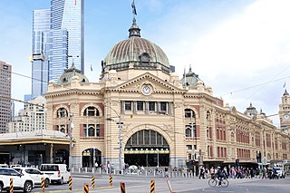
Flinders Street railway station is a train station located on the corner of Flinders and Swanston streets in Melbourne, Victoria, Australia. It is the second busiest train station in Australia, serving the entire metropolitan rail network, 15 tram routes travelling to and from the city, as well as some country and regional V/Line services to eastern Victoria. Opened in 1854, the station is the oldest in Australia, backing onto the Yarra River in the central business district, the complex includes 13 platforms and structures that stretch over more than two city blocks, from east of Swanston Street to nearly at Market Street.

<span class="mw-page-title-main">Southern Cross railway station</span> Melbourne railway station

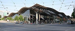
Southern Cross railway station is a major railway station in Docklands, Melbourne. It is on Spencer Street, between Collins and La Trobe streets, at the western edge of the Melbourne central business district. The Docklands Stadium sports arena is 500 metres north-west of the station.

<span class="mw-page-title-main">Timeline of Melbourne history</span>

The following is a timeline of the history of the city of Melbourne, Victoria, Australia.

<span class="mw-page-title-main">Port Melbourne</span> Suburb of Melbourne, Victoria, Australia

Port Melbourne is an inner-city suburb in Melbourne, Victoria, Australia, 3 km (2 mi) south-west of the Melbourne central business district, located within the Cities of Melbourne and Port Phillip local government areas. Port Melbourne recorded a population of 17,633 at the 2021 census.

<span class="mw-page-title-main">Southbank, Victoria</span> Suburb of Melbourne, Victoria, Australia

Southbank is an inner-city suburb in Melbourne, Victoria, Australia, 1 km south of the Melbourne central business district, located within the Cities of Melbourne and Port Phillip local government areas. Southbank recorded a population of 22,631 at the 2021 census.

<span class="mw-page-title-main">Port of Melbourne</span> Port

The Port of Melbourne is the largest port for containerised and general cargo in Australia. It is located in Melbourne, Victoria, and covers an area at the mouth of the Yarra River, downstream of Bolte Bridge, which is at the head of Port Phillip, as well as several piers on the bay itself. Since 1 July 2003, the Port of Melbourne has been managed by the Port of Melbourne Corporation, a statutory corporation created by the State of Victoria.

<span class="mw-page-title-main">Sandridge Bridge</span> Bridge in Melbourne, Australia

The Sandridge Bridge is a historic bridge, originally carrying a railway, over the Yarra River in Melbourne, Victoria, Australia. It runs diagonally to the river's banks and is 178.4 metres (585 ft) long. In 2006 it was redeveloped as a pedestrian and cycle path featuring public art. It is the third bridge on the site and is listed on the Victorian Heritage Register.

<span class="mw-page-title-main">Transport in Melbourne</span> Overview of transport in Melbourne, Victoria, Australia

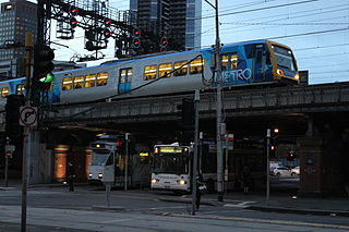
Transport in Melbourne, the state capital of Victoria, Australia, consists of several interlinking modes. Melbourne is a hub for intercity, intracity and regional travel. Road-based transport accounts for most trips across many parts of the city, facilitated by Australia's largest freeway network. Public transport, including the world's largest tram network, trains and buses, also forms a key part of the transport system. Other dominant modes include walking, cycling and commercial-passenger vehicle services such as taxis.

<span class="mw-page-title-main">Princes Bridge</span> Bridge across the Yarra River in Melbourne, Australia

Princes Bridge, originally Prince's Bridge, is a bridge in central Melbourne, Australia that spans the Yarra River. It is built on the site of one of the oldest river crossings in the city, and forms a gateway into the central city from the south. The bridge connects Swanston Street on the north bank of the Yarra River to St Kilda Road on the south bank, and carries road, tram and pedestrian traffic. The present bridge was built in 1888 and is listed on the Victorian Heritage Register.

<span class="mw-page-title-main">Melbourne and Hobson's Bay Railway Company</span> Railway company in Victoria, Australia

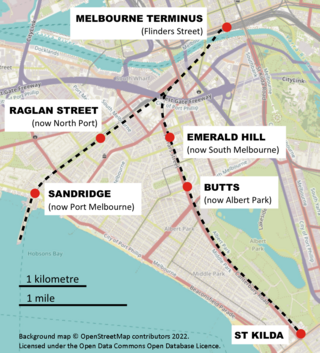
The Melbourne and Hobson's Bay Railway Company was a railway company in Victoria, Australia. The company was incorporated on 20 January 1853 to build the line from Melbourne to the port of Sandridge, now Port Melbourne.

The Port Melbourne railway line is a former railway line in Melbourne, Australia, opened in September 1854, that is now a light rail line. It was instigated by the Melbourne and Hobson's Bay Railway Company to carry passengers arriving in Victoria at Station Pier and to alleviate the high cost of shipping goods using small vessels up the Yarra River to Melbourne. The line's conversion to light rail occurred in 1987; it is now served by tram route 109.

The St Kilda railway line is a former railway line in Melbourne, Australia.

<span class="mw-page-title-main">Graham Street light rail station</span> Light rail station in Melbourne, Victoria

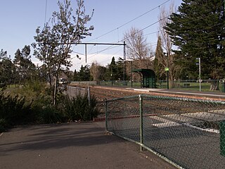
Graham Street is light rail station and former railway station on the former Port Melbourne railway line, in the inner Melbourne suburb of Port Melbourne, Victoria, Australia. Located to the north of Graham Street, between Evans Street and Station Street, the station has been demolished since 1987, and is now served by route 109 trams, stopping at a pair of low level platforms.

<span class="mw-page-title-main">Beacon Cove light rail station</span> Light rail station in Melbourne, Victoria

Beacon Cove is a light rail station in the Melbourne suburb of Port Melbourne located on the former Port Melbourne line, the first significant railway in Australia.

<span class="mw-page-title-main">Montague Street light rail station</span> Light rail station in Melbourne, Victoria

Montague Street is a light rail station and former railway station, on the former Port Melbourne railway line in the inner Melbourne suburb of South Melbourne, Australia. The station was located to the south of the Montague Street road underpass, between Woodgate Street and Gladstone Lane, with a large goods shed located on the Melbourne side of the station. The station buildings and platforms have been demolished, and there are now a pair of low-level platforms forming a tram stop on route 109.

<span class="mw-page-title-main">Flinders Street Viaduct</span> Bridge in Victoria, Australia

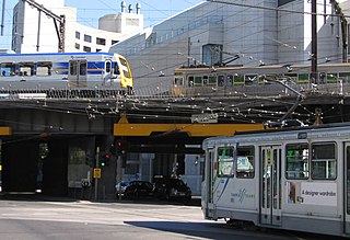
The Flinders Street Viaduct is a railway bridge in Melbourne, Australia. Made up of six tracks built at different times, it links Flinders Street station to Southern Cross station, forming the main connection between the eastern and western parts of the Victorian rail network.

<span class="mw-page-title-main">Princes Pier</span>

Princes Pier is a 580 metre long historic pier on Port Phillip, in Port Melbourne, Victoria, Australia. It was known as the New Railway Pier until renamed Prince's Pier after the Prince of Wales who visited Melbourne in May 1920.

<span class="mw-page-title-main">Jolimont Yard</span>

Jolimont Yard was an array of railway lines and carriage sidings on the edge of the central business district of Melbourne, Australia. Located between Flinders Street station, Richmond Junction, the Yarra River and Flinders Street they were often criticised for cutting off the city from the river, being the site of many redevelopment proposals. The Princes Gate Towers were built over part of the yard in the 1960s, which themselves were replaced by Federation Square in the 2000s. The rail sidings themselves were progressively removed from the 1980s to the 1990s with only running lines today, but the area continues to be referred to as the 'Jolimont railyards' by Melburnians.

The Wailing Wall is a section of brick retaining wall on the Flinders Street Extension, Melbourne, which is famous as the place where Wharf labourers who missed out on the daily work call would congregate.

North Port is a light rail station and a former railway station on Port Melbourne railway line, first significant railway in Melbourne, Australia. The station is located in the inner Melbourne suburb of Port Melbourne, Victoria, Australia. Though it was closed in 1987 for conversion to light rail, Melbourne tram route 109 now runs through the station with newly built low-floor platforms. The station was located to the south of Raglan Street and between Evans Street and Station Street.

References

  1. 1 2 3 4 "Station Pier". www.portofmelbourne.com. Archived from the original on 1 February 2013. Retrieved 31 July 2008.
  2. 1 2 3 "Sandridge Railway Trail guide" (PDF). museumsvictoria.com.au. Retrieved 31 July 2008.
  3. "Station Pier, Southern Section (listing VICH985)". Australia Heritage Places Inventory. Department of Sustainability, Environment, Water, Population and Communities . Retrieved 31 July 2008.
  4. "Pier into the past". The Age. theage.com.au. 2 October 2004. Retrieved 31 July 2008.
  5. Victorian Railways signal diagram "Port Melbourne line - Bridge Street to Piers 1915" . Retrieved 31 July 2008.[ dead link ]
  6. Victorian Railways signal diagram "Port Melbourne line - Bridge Street to Piers 1937" . Retrieved 31 July 2008.[ dead link ]
  7. The Argus (Melbourne, Vic). Friday 27 October 1922, pg. 19
  8. 1 2 3 S.E. Dornan and R.G. Henderson (1979). Electric Railways of Victoria. Australian Electric Traction Society. pp. 58–59. ISBN   0-909459-06-1.
  9. Chris Banger (March 1997). "Rail Passenger Service Withdrawals Since 1960". Newsrail . Vol. 25, no. 3. Vic: ARHS Victoria Division. p. 77–82. ISSN   0310-7477. OCLC   19676396.
  10. Track Extensions Trolley Wire issue 294 November 2000 pages 23-25
  11. Station Pier Tramway Extension Transit Australia February 2002 pages 54/55

Victorian Railways signal diagrams:

Further reading

Preceding station Disused railways Following station
Port Melbourne   Port Melbourne line  Terminus
  List of closed railway stations in Melbourne  

37°50′40″S144°55′52″E / 37.8444°S 144.9311°E / -37.8444; 144.9311