Stackpole Estate

Last updated

Stackpole Estate
Ystad Ystagbwll
BarafundleBeach StackpoleEstate WalesUK.jpg
Barafundle Bay on the Stackpole Estate
Wales location map.svg
Red pog.svg
Map of Wales showing Stackpole Estate within the county of Pembrokeshire
General information
LocationPembrokeshire, Wales
Address9th Bryn Hill
CountryUnited Kingdom
Coordinates 51°37′30″N4°54′09″W / 51.62510°N 4.90238°W / 51.62510; -4.90238
Website
www.nationaltrust.org.uk/main/w-stackpole

The Stackpole Estate (Welsh : Ystad Ystagbwll) is located between the villages of Stackpole (Welsh : Ystagbwll) and Bosherston (Welsh : Llanfihangel-clogwyn-gofan) in Pembrokeshire, Wales, within the Pembrokeshire Coast National Park. It is situated within the community of Stackpole and Castlemartin.

Contents

Consisting of 5 square miles (13 km2) of farmland, lakes, woodland, beaches, and cliffs, the estate is always accessible to visitors. It is owned and maintained by the National Trust.

History of Stackpole Court

Stackpole Court c.1822 Stackpole Court, Pembrokeshire March 1 1822.jpeg
Stackpole Court c.1822

Stackpole Court, a mansion, was built just outside the village of Stackpole. During the English Civil War, the Lort family, who owned the estate from 1611 to 1698, took the side of the King, and the house was besieged by Parliamentarians, to whom they eventually surrendered. When Sir Gilbert Lort died in 1698 the estate passed to his sister Elizabeth who had married Sir Alexander Campbell, Thane of Cawdor, in 1689. She outlived her husband, and on her death in 1714 the estate passed to her son John Campbell. [1]

Stackpole Court c.1920 History and genealogy of the Stackpole family (1920) (14783911853).jpg
Stackpole Court c.1920

A new mansion constructed of limestone was built in later years with extensive gardens, greenhouses and fine collections of plants. Much of the Stackpole Estate farmland was requisitioned at the start of World War II to create a training ground for British troops. Castlemartin Training Area range still occupies this land. This made the estate unviable and The Cawdors returned to their Scottish estate in Nairnshire in the early 1940s. Crippling taxes on the empty mansion meant it was demolished in 1963, leaving behind the estate's outbuildings, parkland and beaches which are looked after by the National Trust and enjoyed by the public today. The is designated Grade I on the Cadw/ICOMOS Register of Parks and Gardens of Special Historic Interest in Wales. [2] The 100 acres (0.40 km2) of lakes, which are today known as the Lily Ponds, were created by the damming of the three narrow limestone valleys in 1780 and 1860 by the Cawdor family. [3]

Etymology

As viewed from the sea, the rock formations at Broad Haven South may have given Stackpole its name BHS Bosherston 2009.jpg
As viewed from the sea, the rock formations at Broad Haven South may have given Stackpole its name

Before the 17th century, the name was recorded in English as Stacpole, Stakepole and Stacpoll. The name is made of two Welsh topographical elements, 'Stac-' (isolated columnar rock) and '-pwll' (a pool). The "stac" in the name is said to be that of Stack rock, at the mouth of Broad Haven South which may have marked the entrance to an ancient waterway, suitable as a harbour. [4] [5]

Geography and ecology

One of the lily ponds Stackpole Lily Ponds (May 2010).jpg
One of the lily ponds

The Stackpole Estate contains the beaches of Barafundle Bay and Broad Haven South. The 100 acres (0.40 km2) of lakes are home to Eurasian otter, goosander, gadwall and kingfisher. From the cliff tops and beaches, bottlenose dolphin and basking shark can sometimes be seen along with species of seabird such as kittiwakes and red-billed choughs. [6] The Stackpole estate contains one of the largest colonies in Britain of the greater horseshoe bat. [7]

Stackpole village

Part of the village Stackpole - geograph.org.uk - 208744.jpg
Part of the village

The village is approximately 4 miles (6.4 km) south of Pembroke in the community of Stackpole and Castlemartin and has a population of around 200. It has its own voluntary controlled primary school for children aged 4 to 11. [8] The school was constructed in the late nineteenth century.

Stackpole village was moved from its original medieval site in 1735 to accommodate the growing Stackpole Estate. However, present day Stackpole is considerably larger than it was then. Stackpole has a public house, The Stackpole Inn, which occupies the former village Post Office, a building of sixteenth-century origin. [9] The village is surrounded on all sides by woodland and arable farmland.

During the 1950s and 1960s, the village expanded with modern homes built at the edge of Deer Park and around the school.

The Eight-Arch Bridge is in part of the estate near Home Farm The bridge at Stackpole Centre - geograph.org.uk - 24400.jpg
The Eight-Arch Bridge is in part of the estate near Home Farm

Just outside the village there is the Stackpole Outdoor Learning Centre which is a multi-purpose venue run by the National Trust with a theatre, licensed bar and conference facilities. It is immediately adjacent to the Lily Ponds and the Eight-Arch Bridge, occupies a part of the estate near Home Farm and is less than a 1-mile (1.6 km) walk from Broad Haven South beach.

Stackpole Elidor church

Stackpole Elidor Church Stackpole Elidor Church - geograph.org.uk - 208258.jpg
Stackpole Elidor Church

St Elidyr's Church, Stackpole is dedicated to St. James and St Elidyr, [10] and goes back to the thirteenth century. It lies at the bottom of a quiet wooded valley with just three small cottages and the rectory in the immediate vicinity. The layout of the church is in the traditional cruciform shape, aligned east to west, with a chancel and nave flanked by two transepts. The tall, slender tower is undoubtedly the oldest part of the present structure, dating back probably to the thirteenth or late twelfth century. It is of the typical South Pembrokeshire form (see Little England Beyond Wales).

It appears that by 1851 the state of the fabric of the church made a complete restoration essential, although the building had been carefully maintained until only a few years before. Richard Fenton, in his Historical Tour through Pembrokeshire published in 1810, quotes from a letter written by Stephen Davies, Canon of St. Davids Cathedral, to the antiquary Browne Willis:

Here I cannot forbear mentioning the generous beneficence of that worthy gentleman, John Campbell Esquire, to the parishes of St. Petrook, Cheriton or Stackpool Elidur and Bosherston on his first coming to the possession of his estate, being about the age of twenty. He waiscotted the three chancels, and otherwise adorned them in a very decent and handsome manner, made new rails about the altar, bestowed new cushions and pulpit cloths and a new set of Communion plate to each.

In 1807 the churchwardens stated that the church was in good repair, but by 1828 they declared that the fabric, though in good repair, was very damp, and by 1848 it was recorded that "not one casement opens".

In 1851 John Frederick Campbell, 1st Earl Cawdor, engaged Sir George Gilbert Scott, the most respected English church architect of the day, to direct the work of restoration. He employed a Cardiff builder, WP James, and the work cost a total of "£1,804 7s 2½d" which adjusted for 2017 would be £144,684.46. [11]

The result is the typical sound, workmanlike building that Scott produced in his renovations, with a tall, narrow chancel arch, colourful Minton tiles on the chancel floor and sanctuary walls, and the Middle English or Decorated style of tracery in the main windows. The transepts retain their fourteenth century vaulting, and the Lort chapel its rib vaulting. There were originally matching hagioscopes on each side of the chancel arch, though the north squint was later blocked by the organ installed in 1874. In the south transept there is a small piscina, probably of the fourteenth century, indicating that there may have been a side altar. [12]

Related Research Articles

<span class="mw-page-title-main">Earl Cawdor</span> Title in the Peerage of the United Kingdom

Earl Cawdor, of Castlemartin in the County of Pembroke, is a title in the Peerage of the United Kingdom. It was created in 1827 for John Campbell, 2nd Baron Cawdor.

<span class="mw-page-title-main">Frederick Campbell, 3rd Earl Cawdor</span> British politician (1847–1911)

Frederick Archibald Vaughan Campbell, 3rd Earl Cawdor,, styled Viscount Emlyn from 1860 to 1898, was a British Conservative politician. He served briefly as First Lord of the Admiralty between March and December 1905.

<span class="mw-page-title-main">Nevern</span> Human settlement in Wales

Nevern is both a parish and a community in Pembrokeshire, Wales. The community includes the settlements of Felindre Farchog, Monington, Moylgrove and Bayvil. The small village lies in the Nevern valley near the Preseli Hills of the Pembrokeshire Coast National Park 2 miles (3 km) east of Newport on the B4582 road.

<span class="mw-page-title-main">St Dogmaels</span> Village in Wales

St Dogmaels is a village, parish and community in Pembrokeshire, Wales, on the estuary of the River Teifi, a mile downstream from the town of Cardigan in neighbouring Ceredigion. A little to the north of the village, further along the estuary, lies Poppit Sands beach. The parish includes the small settlement of Cippyn, south of Cemaes Head.

<span class="mw-page-title-main">John Campbell, 1st Earl Cawdor</span> British politician (1790–1860)

John Frederick Campbell, 1st Earl Cawdor was a British peer and MP.

<span class="mw-page-title-main">John Campbell, 1st Baron Cawdor</span> British politician (died 1821)

John Campbell, 1st Baron Cawdor, FRS FSA, was a Welsh art-collector and politician who sat in the House of Commons from 1777 to 1796.

<span class="mw-page-title-main">Barafundle Bay</span> Beach in Pembrokeshire, Wales

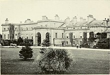
Barafundle Bay is a remote, slightly curved, east-facing sandy beach, near Stackpole Quay in Pembrokeshire, Wales. It is part of the Stackpole Estate, managed by The National Trust. The beach was once owned by the Cawdor family of Stackpole Court. On the northern approach to the beach are steps and a wall, which were built by the owners to ease their access to what was then their private beach.

<span class="mw-page-title-main">Bosherston</span> Village and parish in Pembrokeshire, Wales

Bosherston is a village and parish in Pembrokeshire, Wales, within the Pembrokeshire Coast National Park.

<span class="mw-page-title-main">Broad Haven</span> Human settlement in Wales

Broad Haven is a village and seaside resort in the south east corner of St Bride's Bay at the western terminus of the B4341 road in south Pembrokeshire, Wales.

Castlemartin is a village and parish in the community of Stackpole and Castlemartin, Pembrokeshire, Wales, in the Pembrokeshire Coast National Park.

<span class="mw-page-title-main">Felindre Farchog</span> Human settlement in Wales

Felindre Farchog is a small village in the community of Nevern in Pembrokeshire, Wales, located around 7 miles (11 km) south-west of Cardigan, and within the parish of Bayvil. The A487 road from Cardigan to Newport runs through the village.

<span class="mw-page-title-main">Warren, Pembrokeshire</span> Parish in Pembrokeshire, Wales

Warren is an ancient parish in the community of Stackpole and Castlemartin, in the most southerly part of Pembrokeshire, Wales. Its northern edge is 5 miles (8 km) south of Pembroke and its southern edge reaches the sea at Flimston Bay. It is bordered by Castlemartin to the west, St Twynnells to the east and Monkton to the north.

Slebech was a community in Pembrokeshire, Wales, which is now part of the combined community of Uzmaston and Boulston and Slebech, a sparsely populated community on the northern shore of the Eastern River Cleddau. The community shares boundaries with the communities of Wiston and Llawhaden and mainly consists of farmland and woodland. Much of the community is within the Pembrokeshire Coast National Park and Picton Castle's stable block loft is an important breeding roost for the rare Greater Horseshoe Bat.

<span class="mw-page-title-main">Castlemartin Training Area</span> Ministry of Defence direct-fire AFV live gunnery range in Pembrokeshire, Wales

Castlemartin Training Area is a British Army military training area and armoured fighting vehicle range located in the Welsh county of Pembrokeshire. It was originally established for tank training by the Royal Armoured Corps in 1938. The training area is located within the Pembrokeshire Coast National Park, on the South Pembrokeshire coast.

<span class="mw-page-title-main">Stackpole and Castlemartin</span>

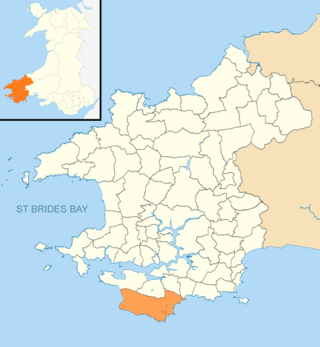
Stackpole and Castlemartin is a community in Pembrokeshire, Wales, 4 miles (6.4 km) south of Pembroke.

<span class="mw-page-title-main">B4329 road</span>

The B4329 is a scenic route and a former turnpike in Pembrokeshire, West Wales. It links Eglwyswrw in the north of the county to Haverfordwest, the county town in the south, in an approximately southwesterly direction, crossing the Preseli Mountains.

<span class="mw-page-title-main">Granston</span> Parish in Pembrokeshire, Wales

Granston is a hamlet and parish in Pembrokeshire, Wales. The parish was in the Hundred of Dewisland and includes the settlements of Llangloffan and Tregwynt, with Tregwynt woollen mill. Granston is in the community of Pencaer.
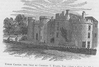
<span class="mw-page-title-main">St Decuman's Church, Rhoscrowther</span> Church in Pembrokeshire, Wales

St Decuman's is a Grade I listed building in Rhoscrowther, Pembrokeshire, Wales.

<span class="mw-page-title-main">Church of St Michael and All Angels, Castlemartin, Pembrokeshire</span> Church in Pembrokeshire, Wales

The Church of St Michael and All Angels, Castlemartin, Pembrokeshire, Wales is a redundant church dating from the 13th century. A Grade I listed building, the church is now in the care of the Friends of Friendless Churches.

<span class="mw-page-title-main">St Elidyr's Church, Stackpole</span> Church in Pembrokeshire, Wales

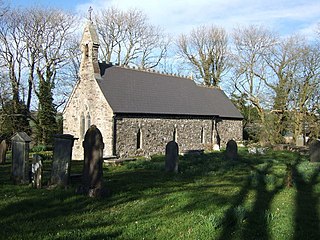
St Elidyr's Church, is a Grade I listed building in south Pembrokeshire, Wales. The church is in the small village of Carew Cheriton in the southwest of the parish of Stackpole Elidor, on the Stackpole Estate in the community of Stackpole and Castlemartin.

References

  1. Express, Britain. "Stackpole Court & Walled Gardens | History, Beautiful Photos & Visiting Information". Britain Express. Retrieved 13 February 2024.
  2. Cadw. "Stackpole Court (PGW(Dy)44(PEM))". National Historic Assets of Wales . Retrieved 6 February 2023.
  3. "Archaeology in Wales - Ymddiriedolaeth Archaeolegol Dyfed - Dyfed Archaeological Trust". dyfedarchaeology.org.uk. Retrieved 13 February 2024.
  4. Harris, P. Valentine (2016). South Pembrokeshire. Read Books Ltd. ISBN   9781473356375.
  5. Lewis, Samuel (1849). A Topographical Dictionary of Wales. London. pp. 368–374. Retrieved 12 July 2022.
  6. "Meet Stackpole's Wildlife". National Trust. Retrieved 14 December 2020.
  7. "Stackpole National Nature Reserve, near Pembroke". Natural Resources Wales. Retrieved 14 December 2020.
  8. "Stackpole VC School" . Retrieved 15 January 2016.
  9. "The Stackpole Inn" . Retrieved 15 January 2016.
  10. "Monkton Rectorial Benefice – Stackpole Church". revjones.fsnet.co.uk. Archived from the original on 4 March 2016.
  11. "National Archives currency converter" . Retrieved 10 July 2023.
  12. "The Stackpole Group consists of four Parishes, Stackpole Elidor, St. Petrox, Bosherston and St. Twynnells". members.multimania.co.uk. Archived from the original on 26 August 2012.

Further reading