Stanford, Kentucky

Last updated
Stanford, Kentucky
StanfordKY-Commercial-District.JPG
Historic Commercial District
Lincoln County Kentucky Incorporated and Unincorporated areas Stanford Highlighted 2173110.svg
Location in Lincoln County, Kentucky
Coordinates: 37°31′53″N84°39′24″W / 37.53139°N 84.65667°W / 37.53139; -84.65667
Country United States
State Kentucky
County Lincoln
Area
[1]
  Total4.47 sq mi (11.58 km2)
  Land4.44 sq mi (11.49 km2)
  Water0.04 sq mi (0.09 km2)
Elevation
[2]
935 ft (285 m)
Population
 (2020)
  Total3,640
  Estimate 
(2022) [3]
3,644
  Density820.56/sq mi (316.83/km2)
Time zone UTC-5 (Eastern (EST))
  Summer (DST) UTC-4 (EDT)
ZIP code
40484
Area code 606
FIPS code 21-73110
GNIS feature ID2405519 [2]
Website www.stanford.ky.gov

Stanford is a home rule-class city in Lincoln County, Kentucky, United States. It is one of the oldest settlements in Kentucky, having been founded in 1775. Its population was 3,487 at the 2010 census [4] and an estimated 3,686 in 2018. [5] It is the county seat of Lincoln County. [6] Stanford is part of the Danville Micropolitan Statistical Area.

Contents

History

Lincoln County Courthouse Lincoln County Courthouse (Stanford, Kentucky).jpg
Lincoln County Courthouse

Stanford was founded in 1775 by Benjamin Logan as "St. Asaph"; the early settlement was also known simply as "Logan's Fort". [7] The site of the fort is about one mile west of the courthouse at the center of town. The name "Fort Logan" is still used to this day by local businesses, including the Fort Logan Hospital and Standing Fort Collectibles. The main street was built on what was originally a buffalo trail. [8]

The name "Stanford" may have come from "Standing Fort", a name given to Fort Logan because it survived multiple attacks by British-led Native Americans during the American Revolution. Alternately, it may have been named for Stamford, England. [7] Although it was one of the smaller pioneer forts, it never fell to an attack.[ citation needed ]

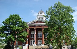
In 1781, the original settlement expanded when Benjamin Logan donated part of his own land as the site for a courthouse. The county court continued to meet at Fort Harrod (now Harrodsburg) until 1785, when Mercer County was established. By 1786 Stanford had received its charter, making it one of the first towns in the former (1776–1780) Kentucky County, Virginia, with a formal charter. In 1787 the courthouse opened in a building made of logs. It has been expanded and upgraded over time, but the courthouse remains on the same site. Unlike most courthouses in Kentucky, it has never suffered from a fire or other major loss of records. Lincoln County has all its original records and archives dating from November 1789, making it one of the more complete archives in Kentucky. Among its original land deeds kept on vellum are deeds granting land to both Daniel Boone and Simon Kenton.

The first recorded church in Stanford was a Presbyterian church built in 1790, reflecting the staunch Presbyterian beliefs of the Logan family. The building still stands and is now part of the Harvey Helm Memorial Historic Library and Museum on Main Street. Other denominations, including Baptist and Methodist, were not established in the area until the 1830s. The current Presbyterian Church in Stanford has stood on the same site since around 1850. [8]

A small local library was first established in the 1830s. The library was renamed in 1970 in honor of Harvey Helm, a native son who became a Kentucky statesman and member of the United States House of Representatives between 1909 and 1917. [8]

The first school was built sometime in the 1850s, as the Male Academy. It was established in a building that is now the Fox Funeral Home on West Main Street. The corresponding Female Academy was built in the 1870s. The Stanford School was founded in 1900, and after much expansion, still serves, now as the Lincoln County Student Support Center. [8]

Largely untouched by the American Civil War (the nearest conflict was the Battle of Perryville, 20 miles (32 km) away), Stanford grew significantly in the post-war period. In the late 1860s, the town gained its own newspaper, the Stanford Banner, which is still publishing as the Interior Journal. The city continued to grow, especially after the Louisville and Nashville Railroad built a station and line into the town in late 1865. Now the railroad line has closed, and the tracks were removed in 1988, leaving only a small spur line that connects to Mount Vernon, 24 miles (39 km) to the southeast. However, the railway depot has been restored, and Stanford is notable as the location of the first automobile garage in Kentucky, which opened in 1905.[ citation needed ]

Geography

Stanford is located in south-central Kentucky in the southernmost extent of the Bluegrass region along the Southern Knobs in northern Lincoln County. U.S. Route 27 passes through the east side of the city, leading northeast 8 miles (13 km) to Lancaster and 43 miles (69 km) to Lexington, and south 32 miles (51 km) to Somerset. U.S. Route 150 passes through the northern side of the city, leading northwest 10 miles (16 km) to Danville and southeast 24 miles (39 km) to Mount Vernon.

According to the United States Census Bureau, Stanford has a total area of 4.2 square miles (10.8 km2), of which 0.04 square miles (0.1 km2), or 0.85%, are water. [9]

Demographics

Historical population
CensusPop.Note
1800 66
1830 363
1840 263−27.5%
1860 479
1870 75257.0%
1880 1,21361.3%
1890 1,38514.2%
1900 1,65119.2%
1910 1,532−7.2%
1920 1,397−8.8%
1930 1,54410.5%
1940 1,94025.6%
1950 1,861−4.1%
1960 2,0198.5%
1970 2,47422.5%
1980 2,76411.7%
1990 2,686−2.8%
2000 3,43027.7%
2010 3,4871.7%
2020 3,6404.4%
2022 (est.)3,644 [10] 0.1%
U.S. Decennial Census [11]

As of the census [12] of 2000, there were 3,430 people, 1,417 households, and 919 families residing in the city. The population density was 1,114.5 per square mile (430.3/km2). There were 1,522 housing units at an average density of 494.6 per square mile (191.0/km2). The racial makeup of the city was 89.97% White, 8.10% African American, 0.09% Native American, 0.09% Asian, 0.20% from other races, and 1.55% from two or more races. Hispanic or Latino of any race were 1.37% of the population.

There were 1,417 households, out of which 29.6% had children under the age of 18 living with them, 46.1% were married couples living together, 15.9% had a female householder with no husband present, and 35.1% were non-families. 31.8% of all households were made up of individuals, and 15.2% had someone living alone who was 65 years of age or older. The average household size was 2.27 and the average family size was 2.85.

22.8% of the population was under the age of 18, 8.3% from 18 to 24, 28.5% from 25 to 44, 22.1% from 45 to 64, and 18.4% who were 65 years of age or older. The median age was 38 years. For every 100 females, there were 84.1 males. For every 100 females age 18 and over, there were 79.7 males.

The median income for a household in the city was $25,087, and the median income for a family was $32,550. Males had a median income of $28,583 versus $20,975 for females. The per capita income for the city was $13,811. About 15.9% of families and 20.6% of the population were below the poverty line, including 27.4% of those under age 18 and 27.8% of those age 65 or over.

Education

Stanford has a lending library, the Lincoln County Public Library. [13]

Notable people

Related Research Articles

<span class="mw-page-title-main">Shelby County, Iowa</span> County in Iowa, United States

Shelby County is a county located in the U.S. state of Iowa. As of the 2020 census, the population was 11,746. The county seat is Harlan. Its name is in honor of Isaac Shelby, the first Governor of Kentucky.

<span class="mw-page-title-main">Washington County, Kentucky</span> County in Kentucky, United States

Washington County is a county located in the U.S. state of Kentucky. As of the 2020 census, the population was 12,027. Its county seat is Springfield. The county is named for George Washington. Washington County was the first county formed in the Commonwealth of Kentucky when it reached statehood, and the sixteenth county formed. The center of population of Kentucky is located in Washington County, in the city of Willisburg. The county is dry, meaning that the sale of alcohol is prohibited, but it contains the "wet" city of Springfield, where retail alcohol sales are allowed. This classifies the jurisdiction as a moist county. Three wineries operate in the county and are licensed separately to sell to the public. Jacob Beam, founder of Jim Beam whiskey, sold his first barrel of whiskey in Washington County.

<span class="mw-page-title-main">Lincoln County, Kentucky</span> County in Kentucky, United States

Lincoln County is a county located in south-central Kentucky. As of the 2020 census, the population was 24,275. Its county seat is Stanford. Lincoln County is part of the Danville, KY Micropolitan Statistical Area.

<span class="mw-page-title-main">LaRue County, Kentucky</span> County in Kentucky, United States

LaRue County is a county in the central region of the U.S. state of Kentucky, outside the Bluegrass Region and larger population centers. As of the 2020 census, the population was 14,867. Its county seat is Hodgenville, which is best known as the birthplace of United States President Abraham Lincoln. The county was established on March 4, 1843, from the southeast portion of Hardin County. It was named for John P. LaRue, an early settler. LaRue County is included in the Elizabethtown-Fort Knox, KY Metropolitan Statistical Area, which is also included in the Louisville/Jefferson County-Elizabethtown-Bardstown, KY-IN Combined Statistical Area. It is a dry county.

<span class="mw-page-title-main">Casey County, Kentucky</span> County in Kentucky, United States

Casey County is a county located in the U.S. Commonwealth of Kentucky. As of the 2020 census, the population was 15,941. Its county seat is Liberty. The county was formed in 1806 from the western part of Lincoln County and named for Colonel William Casey, a pioneer settler who moved his family to Kentucky in 1779. It is the only Kentucky county entirely in the Knobs region. Casey County is home to annual Casey County Apple Festival, and is a prohibition or dry county. It is considered part of the Appalachian region of Kentucky.

<span class="mw-page-title-main">Calloway County, Kentucky</span> County in Kentucky, United States

Calloway County is a county located in the southwest portion of the U.S. Commonwealth of Kentucky. As of the 2020 census, the population was 37,103. Its county seat is Murray. The county was founded in November 1822 and named for Colonel Richard Callaway, one of the founders of Boonesborough. Calloway County comprises the Murray, KY Micropolitan Statistical Area. As of July 18, 2012 Calloway County is a moist county: the sale of alcohol in the county is prohibited, with the exception of the city of Murray.

<span class="mw-page-title-main">Wickliffe, Kentucky</span> City in Kentucky, United States

Wickliffe is a home rule-class city in Ballard County, Kentucky, United States. The population was 688 at the 2010 census. It is the county seat of Ballard County.

<span class="mw-page-title-main">Alexandria, Kentucky</span> City in Kentucky, United States

Alexandria is a home rule-class city in Campbell County, Kentucky, in the United States. Along with Newport, it is one of the dual seats of the county. The population was 10,341 at the 2020 census.

<span class="mw-page-title-main">Albany, Kentucky</span> City in Kentucky, United States

Albany is a home rule-class city in Clinton County, Kentucky, in the United States. The population was 2,033 at the 2010 census. It is the county seat of Clinton County. It is located on U.S. Route 127, about 6 miles (10 km) north of the Tennessee border.

<span class="mw-page-title-main">Burkesville, Kentucky</span> City in Kentucky, United States

Burkesville is a home rule-class city in Cumberland County, Kentucky, in the United States. Nestled among the rolling foothills of Appalachia and bordered by the Cumberland River to the south and east, it is the seat of its county. The population was 1,521 at the 2010 census.

<span class="mw-page-title-main">Greensburg, Kentucky</span> City in Kentucky, United States

Greensburg is a home rule-class city in and the county seat of Green County, Kentucky, United States. The population was 2,163 at the 2010 census, down from 2,396 at the 2000 census.

<span class="mw-page-title-main">Hodgenville, Kentucky</span> City in Kentucky, United States

Hodgenville is a home rule-class city in LaRue County, Kentucky, United States. It is the seat of its county. Hodgenville sits along the North Fork of the Nolin River. The population was 3,206 at the 2010 census. It is included in the Elizabethtown metropolitan area.

<span class="mw-page-title-main">Crab Orchard, Kentucky</span> City in Kentucky, United States

Crab Orchard is a home rule-class city in Lincoln County, Kentucky, United States. The population was 841 at the 2010 census. It is part of the Danville Micropolitan Statistical Area.

<span class="mw-page-title-main">Hustonville, Kentucky</span> City in Kentucky, United States

Hustonville is a home rule-class city in Lincoln County, Kentucky, in the United States. The population was 405 at the 2010 census. It is part of the Danville Micropolitan Statistical Area.

<span class="mw-page-title-main">Adairville, Kentucky</span> City in Kentucky, United States

Adairville is a home rule-class city in Logan County, Kentucky, in the United States. Established on January 31, 1833, it was named for Governor John Adair and incorporated by the state assembly on February 7, 1871. The population was 852 at the 2010 census.

<span class="mw-page-title-main">West Liberty, Kentucky</span> City in Kentucky, United States

West Liberty is a home rule-class city in Morgan County, Kentucky, United States. It is the county seat of Morgan County. As of the 2020 census, the city population was 3,215. It is located along the Licking River at the junction of Kentucky Route 7 and U.S. Route 460.

<span class="mw-page-title-main">Owenton, Kentucky</span> City in Kentucky, United States

Owenton is a home rule-class city in and the county seat of Owen County, Kentucky, United States. The population was 1,327 at the 2010 census. It is located at the junction of U.S. Route 127 and Kentucky Route 22, about halfway between Louisville and Cincinnati.

<span class="mw-page-title-main">Booneville, Kentucky</span> City in Kentucky, United States

Booneville is a home rule-class city in Owsley County, Kentucky, in the United States. The population was 81 at the 2010 census. It is the county seat of Owsley County. It is located at the junction of Kentucky Route 11 and Kentucky Route 30 on the South Fork of the Kentucky River.

<span class="mw-page-title-main">Springfield, Kentucky</span> City in Kentucky, United States

Springfield is a home rule-class city in and county seat of Washington County, Kentucky, United States. The population was 2,846 at the 2020 census.

<span class="mw-page-title-main">Eubank, Kentucky</span> City in Kentucky, United States

Eubank is a home rule-class city in Pulaski and Lincoln counties in southern Kentucky. The population was 319 at the 2010 census.

References

  1. "2020 U.S. Gazetteer Files". United States Census Bureau. Retrieved March 18, 2022.
  2. 1 2 U.S. Geological Survey Geographic Names Information System: Stanford, Kentucky
  3. "Annual Estimates of the Resident Population for Incorporated Places in Kentucky: April 1, 2020 to July 1, 2022". United States Census Bureau. Retrieved May 26, 2023.
  4. "Total Population: 2010 Census DEC Summary File 1 (P1), Stanford city, Kentucky". data.census.gov. U.S. Census Bureau. Retrieved February 13, 2020.
  5. "Population and Housing Unit Estimates" . Retrieved November 13, 2019.
  6. "Find a County". National Association of Counties. Retrieved 2011-06-07.
  7. 1 2 "Kentucky Atlas and Gazetteer: Stanford". University of Kentucky . Retrieved 2009-01-17.
  8. 1 2 3 4 Kleber, John E. (1992). The Kentucky Encyclopedia. Lexington KY: The University Press of Kentucky. ISBN   0-8131-1772-0.
  9. "U.S. Gazetteer Files: 2019: Places: Kentucky". U.S. Census Bureau Geography Division. Retrieved February 13, 2020.
  10. "Annual Estimates of the Resident Population for Incorporated Places in Kentucky: April 1, 2020 to July 1, 2022". United States Census Bureau. Retrieved May 26, 2023.
  11. "Census of Population and Housing". Census.gov. Retrieved June 4, 2015.
  12. "U.S. Census website". United States Census Bureau . Retrieved 2008-01-31.
  13. "Kentucky Public Library Directory". Kentucky Department for Libraries and Archives. Archived from the original on 11 January 2019. Retrieved 5 June 2019.