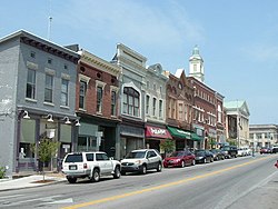
Versailles, Kentucky

Last updated

Versailles, Kentucky
VersaillesKYMainStJBm82008.jpg
Main Street
Motto: 
"Proud to be a Kentucky Renaissance City"
Woodford County Kentucky Incorporated and Unincorporated areas Versailles Highlighted 2179482.svg
Location of Versailles in Woodford County, Kentucky.
Coordinates: 38°02′55″N84°43′33″W / 38.04861°N 84.72583°W / 38.04861; -84.72583
CountryUnited States
State Kentucky
County Woodford
EstablishedJune 24, 1794
Government
  Type Mayor-Council
  MayorBrian Traugott
Area
[1]
  Total6.35 sq mi (16.44 km2)
  Land6.31 sq mi (16.33 km2)
  Water0.04 sq mi (0.11 km2)
Elevation
[2]
912 ft (278 m)
Population
 (2020)
  Total10,347
  Estimate 
(2022) [3]
10,416
  Density1,640.56/sq mi (633.44/km2)
Time zone UTC-5 (Eastern (EST))
  Summer (DST) UTC-4 (EDT)
ZIP codes
40383, 40384, 40386
Area code 859
FIPS code 21-79482
GNIS feature ID2405645 [2]
Website versailles.klc.gov

Versailles is a home rule-class city in Woodford County, Kentucky, United States. It lies 13 miles (21 kilometers) by road west of Lexington and is part of the Lexington-Fayette Metropolitan Statistical Area. Versailles has a population of 9,316 according to 2017 census estimates. [4] It is the county seat of Woodford County. [5] The city's name is pronounced /vərˈslz/ vər-SAYLZ, an anglicization different from the French pronunciation of the royal city of the same name near Paris.

Contents

History

Versailles was founded on June 23, 1792, on 80 acres (32 hectares) of land owned by Hezekiah Briscoe, who was, at the time, only a child. His guardian, Marquis Calmes, named the town after Versailles, France, in honor of General Lafayette, a family friend and hero of the American Revolution. Located in what became known as the Bluegrass Region of Kentucky, where farmers also raised thoroughbred horses and other high-quality livestock, the city was officially incorporated on February 13, 1837. It was briefly occupied during the American Civil War by both Confederate and Union forces.

In 1870, black residents of Versailles took part in a demonstration against police violence after a white officer struck a black man with his pistol. Demonstrators formed armed pickets and guarded roads in and out of Versailles. Two of the leaders were subsequently lynched by a local militia company. [6] [7] [8]

Geography

According to the United States Census Bureau, the city has a total area of 2.8 square miles (7.3 km2), all land.

Demographics

Historical population
CensusPop.Note
1800 172
1810 488183.7%
1830 904
1840 1,04415.5%
1860 1,142
1870 3,268186.2%
1900 2,337
1910 2,268−3.0%
1920 2,056−9.3%
1930 2,33813.7%
1940 2,5489.0%
1950 2,7608.3%
1960 4,06047.1%
1970 5,67939.9%
1980 6,42713.2%
1990 7,26913.1%
2000 7,5113.3%
2010 8,56814.1%
2020 10,34720.8%
2022 (est.)10,416 [9] 0.7%
U.S. Decennial Census [10]

As of the census [11] of 2000, there were 7,511 people, 3,160 households, and 2,110 families residing in the city. The population density was 2,668.7 per square mile (1,030.4/km2). There were 3,330 housing units at an average density of 1,183.2 per square mile (456.8/km2). The racial makeup of the city was 96.18% White, 0.67% African American, 0.15% Native American, 0.35% Asian, 0.01% Pacific Islander, 1.34% from other races, and 1.30% from two or more races. Hispanic or Latino of any race were 4.29% of the population.

There were 3,160 households, out of which 29.5% had children under the age of 18 living with them, 48.7% were married couples living together, 14.4% had a female householder with no husband present, and 33.2% were non-families. 28.4% of all households were made up of individuals, and 11.8% had someone living alone who was 65 years of age or older. The average household size was 2.37 and the average family size was 2.89.

23.2% of the population was under the age of 18, 10.1% from 18 to 24, 29.4% from 25 to 44, 23.7% from 45 to 64, and 13.6% who were 65 years of age or older. The median age was 37 years. For every 100 females, there were 88.6 males. For every 100 females age 18 and over, there were 86.8 males.

The median income for a household in the city was US $35,052, and the median income for a family was $41,567. Males had a median income of $31,056 versus $24,488 for females. The per capita income for the city was $18,489. About 11.1% of families and 14.0% of the population were below the poverty line, including 16.0% of those under age 18 and 20.9% of those age 65 or over.

Economy

In the Inner Bluegrass Region, the area is a center for horse breeding and training, and for thoroughbred and standardbred racehorses and saddlebred pleasure horses.

Thoroughbred farms include Woodburn Stud, Lane's End Farm, and WinStar Farm.

Located in Versailles is Woodford Reserve Distillery, a station on the Bourbon Trail, and the Bluegrass Railroad and Museum.

Film industry

Most of the small-town scenes in the movie Elizabethtown (2005) were filmed in Versailles. It was also the setting of the movie Dreamer: Inspired by a True Story (2005). The cemetery scene in the film Secretariat (2010), about one of Kentucky's major race and stud horses, was filmed at Pisgah Pike Church. The Flim-Flam Man (1967) was filmed at several locations near Versailles. The opening sequence was filmed at Paynes Depot, and a car chase was filmed on Clifton Road.

Education

Versailles has a lending library, a branch of the Woodford County Public Library. [12]

Notable people

Related Research Articles

<span class="mw-page-title-main">Lexington, Kentucky</span> City in Kentucky, United States

Lexington is the second-most-populous city in the Commonwealth of Kentucky, and the 60th-most populous city in the United States. It is the county seat of Fayette County. By land area, it is the country's 30th-largest city.

<span class="mw-page-title-main">Woodford County, Kentucky</span> County in Kentucky, United States

Woodford County is a county located in the U.S. state of Kentucky. As of the 2020 census, the population was 26,871. Its county seat is Versailles. The area was home to Pisgah Academy. Woodford County is part of the Lexington-Fayette, KY Metropolitan Statistical Area. It is located in the center of the Bluegrass region of Kentucky.

<span class="mw-page-title-main">Scott County, Kentucky</span> County in Kentucky, United States

Scott County is a county located in the central part of the U.S. state of Kentucky. As of the 2020 census, the population was 57,155. Scott County is part of the Lexington-Fayette, Kentucky Metropolitan Statistical Area. Its county seat and largest city is Georgetown.

<span class="mw-page-title-main">Jessamine County, Kentucky</span> County in Kentucky, United States

Jessamine County is a county located in the U.S. state of Kentucky. As of the 2020 census, the population was 52,991. Its county seat is Nicholasville. The county was founded in December 1798. Jessamine County is part of the Lexington-Fayette, KY Metropolitan Statistical Area. It is within the Inner Blue Grass region, long a center of farming and blooded stock raising, including thoroughbred horses. The legislature established a commercial wine industry here in the late 18th century.

<span class="mw-page-title-main">Fayette County, Kentucky</span> County in Kentucky, United States

Fayette County is located in the central part of the U.S. state of Kentucky and is consolidated with the city of Lexington. As of the 2020 census, the population was 322,570, making it the second-most populous county in the commonwealth. Since 1974, its territory, population and government have been shared with Lexington. Fayette County is part of the Lexington-Fayette, KY Metropolitan Statistical Area.

<span class="mw-page-title-main">Anderson County, Kentucky</span> County in Kentucky, United States

Anderson County, located in the Outer Bluegrass physiographic region, is Kentucky's 48th most populated and ninth fastest-growing county.

<span class="mw-page-title-main">Winchester, Kentucky</span> City in Kentucky, United States

Winchester is a home rule-class city in and the county seat of Clark County, Kentucky, United States. The population was 19,134 at the 2020 census. It is part of the Lexington-Fayette, KY Metropolitan Statistical Area. Winchester is located roughly halfway between Lexington and Mt. Sterling.

<span class="mw-page-title-main">Flemingsburg, Kentucky</span> City in Kentucky, United States

Flemingsburg is a home rule-class city in Fleming County, Kentucky, in the United States. The population was 2,953 at the 2020 census, up from 2,658 at the 2010 census. It is the seat of Fleming County.

<span class="mw-page-title-main">Jeffersontown, Kentucky</span> City in Kentucky, United States

Jeffersontown is a home rule-class city in Jefferson County, Kentucky, United States. The population was 28,474 at the 2020 census.

Keeneland is a former city in Jefferson County, Kentucky, United States, that was dissolved on January 1, 2001, and annexed by the neighboring City of Lyndon. Keeneland is now a neighborhood of Lyndon and also a part of Louisville Metro.

<span class="mw-page-title-main">Hindman, Kentucky</span> City in Kentucky, United States

Hindman is a home rule-class town in, and the county seat of, Knott County, Kentucky, in the United States. The population was 777 at the 2010 U.S. census.

<span class="mw-page-title-main">Russellville, Kentucky</span> City in Kentucky, United States

Russellville is a home rule-class city in Logan County, Kentucky, in the United States. It is the seat of its county. The population was 6,960 at the time of the 2010 census.

<span class="mw-page-title-main">Mount Sterling, Kentucky</span> City in Kentucky, United States

Mount Sterling, often written as Mt. Sterling, is a home rule-class city in Montgomery County, Kentucky, United States. The population was 7,558 as of the 2020 census, up from 6,895 in 2010. It is the county seat of Montgomery County and the principal city of the Mount Sterling micropolitan area.

<span class="mw-page-title-main">Goshen, Kentucky</span> City in Kentucky, United States

Goshen is a home rule-class city in Oldham County, Kentucky, in the United States. The population was 892 at the 2020 census.

<span class="mw-page-title-main">Stanton, Kentucky</span> City in Kentucky, United States

Stanton is a home rule-class city in and the county seat of Powell County, Kentucky, United States. The population was 3,251 in the 2020 census.

<span class="mw-page-title-main">Somerset, Kentucky</span> City in Kentucky, United States

Somerset is a home rule-class city in Pulaski County, Kentucky, United States. The city population was 11,924 according to the 2020 census. It is the seat of Pulaski County.

<span class="mw-page-title-main">Georgetown, Kentucky</span> City in Kentucky, United States

Georgetown is a home rule-class city in Scott County, Kentucky, United States. The population was 37,086 at the 2020 census. It is the 6th-largest city by population in the U.S. state of Kentucky. It is the seat of its county. It was originally called Lebanon when founded by Rev. Elijah Craig and was renamed in 1790 in honor of President George Washington. Historically, settlers were drawn to Georgetown for its Royal Spring.

<span class="mw-page-title-main">Shelbyville, Kentucky</span> City in Kentucky, United States

Shelbyville is a home rule-class city in and the county seat of Shelby County, Kentucky, United States. The population was 17,282 at the 2020 census.

<span class="mw-page-title-main">Midway, Kentucky</span> City in Kentucky, United States

Midway is a home rule-class city in Woodford County, Kentucky, in the United States. Its population was 1,741 at the time of the year 2020 U.S. census. It is part of the Lexington-Fayette Metropolitan Statistical Area.

<span class="mw-page-title-main">Belle Reve Farm</span> Horse farm in Kentucky owned by William Shatner.

Belle Reve Farm is a horse farm located in Versailles, Kentucky that was owned by actor William Shatner, a breeder of American Saddlebred show horses.

References

  1. "2020 U.S. Gazetteer Files". United States Census Bureau. Retrieved March 18, 2022.
  2. 1 2 U.S. Geological Survey Geographic Names Information System: Versailles, Kentucky
  3. "Annual Estimates of the Resident Population for Incorporated Places in Kentucky: April 1, 2020 to July 1, 2022". United States Census Bureau. Retrieved May 26, 2023.
  4. "World Population Review" . Retrieved February 25, 2020.
  5. "Find a County". National Association of Counties. Archived from the original on May 31, 2011. Retrieved June 7, 2011.
  6. Aaron Astor, Rebels on the Border: Civil War, Emancipation, and the Reconstruction (Baton Rouge: Louisiana State University Press, 2012), 237-238
  7. Victor B. Howard, Black Liberation in Kentucky: Emancipation and Freedom, 1862-1884 (Lexington: University Press of Kentucky, 1983), 101
  8. George C. Wright, Racial Violence in Kentucky, 1865-1940: Lynchings, Mob Rule, and 'Legal Lynchings'" (Baton Rouge: Louisiana State University Press, 1990), 48.
  9. "Annual Estimates of the Resident Population for Incorporated Places in Kentucky: April 1, 2020 to July 1, 2022". United States Census Bureau. Retrieved May 26, 2023.
  10. "Census of Population and Housing". Census.gov. Retrieved June 4, 2015.
  11. "U.S. Census website". United States Census Bureau . Retrieved January 31, 2008.
  12. "Kentucky Public Library Directory". Kentucky Department for Libraries and Archives. Archived from the original on January 11, 2019. Retrieved June 7, 2019.