Ste. Marie, Illinois

Last updated

Ste. Marie, Illinois
Sainte Marie
Jasper County Illinois Incorporated and Unincorporated areas Ste. Marie Highlighted.svg
Location of Ste. Marie in Jasper County, Illinois
Illinois in United States (US48).svg
Location of Illinois in the United States
Coordinates: 38°55′56″N88°01′24″W / 38.93222°N 88.02333°W / 38.93222; -88.02333 [1]
CountryUnited States
StateIllinois
County Jasper
Township Ste. Marie
Government
  Village presidentJack Thompson
Area
[2]
  Total1.11 sq mi (2.87 km2)
  Land1.11 sq mi (2.87 km2)
  Water0.00 sq mi (0.00 km2)
Elevation
[1]
486 ft (148 m)
Population
 (2020)
  Total238
  Density214.61/sq mi (82.88/km2)
Time zone UTC-6 (CST)
  Summer (DST) UTC-5 (CDT)
ZIP code
62459
Area code 618
FIPS code 17-66800
GNIS feature ID419080 [1]
Wikimedia CommonsSte. Marie, Illinois

Ste. Marie is a village in Jasper County, Illinois, United States, along the Embarras River. The population was 244 at the 2010 census. [3]

Contents

Early history

In the early 1800s, some French had become greatly concerned and dismayed by the effects on the Catholic Church from the French Revolution and the attacks by unbelieving philosophers. Some families, including the Picquets, began to consider emigrating in order to establish elsewhere a new social order based on the principles of the Gospel. In 1835, 19-year-old Joseph Picquet was sent to the United States to "spy out the land" and report back to the family. Joseph landed in New York and worked for nine months in a business house in Philadelphia. In early 1836, Joseph began his exploration of the country. His travels took him to Pittsburgh; Lima, Ohio; Fort Wayne, Indiana; Indianapolis; Vincennes, Indiana; Vandalia, Illinois; and St. Louis. Instructed to stay away from large cities, he turned eastward and finally decided on the land in Eastern Illinois that is now Ste. Marie, partly because of its proximity to Vincennes, a strong French city with an availability of priests to say Mass. At that time there was not a single house between Newton and Olney. In October 1836 Joseph returned to France and gave a favorable report of the land.

On January 29, 1837, an association of five including Jacques Picquet, Joseph Picquet, Joseph Schifferstein, Charles Hoffman and Joseph Picquet was formed, with the intent of acquiring and developing land in the United States. A contract was written and signed by the members of the association. On June 20, Joseph returned to the United States with the nucleus of a colony, all related by either blood or marriage, 25 in all, on the ship Mogul. Because they were all related, the new settlement was to be named Colonie des Freres or "Colony of Brothers". On July 20, the new immigrants bought a small farm near St. Francisville where they stayed for several months. On October 1, the settlers left St. Francisville and came to begin their new settlement. They boarded with William Price who had a cabin nearby. On October 12, Ferdinand Hartrich, Etienne Lauer and Joseph Picquet went to Palestine and recorded approximately 12,000 acres (49 km2) in the Land Office there.

Father Stephen Theodore Badin, a Frenchman, came during this time to bless this work of their own hands and celebrate the Holy Sacrifice of the Mass in their presence. Father Badin was the first Catholic priest ordained in the United States. A stone monument fashioned to look like a log cabin stands on the grounds of the University of Notre Dame as a tribute to him. There is also a mosaic on the east porch of the Cathedral of the Immaculate Conception in Washington, D.C. in memory of him.

On October 28, 1837, the settlers gathered on a knoll south of the Embarras River and took formal possession of the land, dedicating the village to the Virgin Mary. The newly acquired land was called Colonie des Freres, or "Colony of Brothers". Eventually the name of the new settlement was changed to "St. Marie", with the name changing in 1892 to the French feminine version of the spelling.

Joseph Picquet made many more trips back to France to bring other family members to the new colony.

Ste. Marie quickly grew and erected its first church, free school, post office and store. It served as a cultural center amidst miles of wilderness.

Geography

Ste. Marie is located in southeastern Jasper County at 38°55′53″N88°1′31″W / 38.93139°N 88.02528°W / 38.93139; -88.02528 (38.931480, −88.025205). [4] It is 9 miles (14 km) southeast of Newton, the county seat.

According to the 2010 census, Ste. Marie has a total area of 1.11 square miles (2.87 km2), all land. [5]

Demographics

Historical population
CensusPop.Note
1880 243
1890 31830.9%
1900 40627.7%
1910 45010.8%
1920 351−22.0%
1930 304−13.4%
1940 293−3.6%
1950 35220.1%
1960 347−1.4%
1970 335−3.5%
1980 312−6.9%
1990 281−9.9%
2000 261−7.1%
2010 244−6.5%
2020 238−2.5%
U.S. Decennial Census [6]

As of the census [7] of 2000, there were 261 people, 116 households, and 69 families residing in the village. The population density was 234.7 inhabitants per square mile (90.6/km2). There were 122 housing units at an average density of 109.7 per square mile (42.4/km2). The racial makeup of the village was 100.00% White. Hispanic or Latino of any race were 0.38% of the population.

There were 116 households, out of which 22.4% had children under the age of 18 living with them, 52.6% were married couples living together, 6.0% had a female householder with no husband present, and 40.5% were non-families. 37.1% of all households were made up of individuals, and 28.4% had someone living alone who was 65 years of age or older. The average household size was 2.25 and the average family size was 2.99.

In the village, the population was spread out, with 23.8% under the age of 18, 6.5% from 18 to 24, 23.8% from 25 to 44, 16.1% from 45 to 64, and 29.9% who were 65 years of age or older. The median age was 40 years. For every 100 females, there were 74.0 males. For every 100 females age 18 and over, there were 74.6 males.

The median income for a household in the village was $32,500, and the median income for a family was $37,344. Males had a median income of $24,375 versus $15,833 for females. The per capita income for the village was $14,479. About 5.6% of families and 6.8% of the population were below the poverty line, including none of those under the age of eighteen and 15.4% of those 65 or over.

Civics

Churches
Government/School

Related Research Articles

<span class="mw-page-title-main">Ste. Genevieve County, Missouri</span> County in Missouri, United States

Sainte Genevieve County, often abbreviated Ste. Genevieve County, is a county located in the eastern portion of the U.S. state of Missouri. As of the 2020 census, the population was 18,479. The largest city and county seat is Ste. Genevieve. The county was officially organized on October 1, 1812, and is named after the Spanish district once located in the region, after Saint Genevieve, patroness of Paris, France.

<span class="mw-page-title-main">Randolph County, Illinois</span> County in Illinois, United States

Randolph County is a county located in the U.S. state of Illinois. According to the 2020 census, it had a population of 30,163. Its county seat is Chester.

<span class="mw-page-title-main">Whitmore Village, Hawaii</span> Census-designated place in Hawaii, United States

Whitmore Village is a census-designated place (CDP) in Honolulu County, Hawaiʻi, United States. The population was 4,887 at the 2020 census.

<span class="mw-page-title-main">Ivesdale, Illinois</span> Village in Illinois, United States

Ivesdale is a village in Champaign County, Illinois, United States; a very small portion of the village extends into Piatt County, Illinois. The population was 265 at the 2020 census.

<span class="mw-page-title-main">Greenup, Illinois</span> Village in Illinois, United States

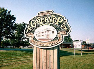
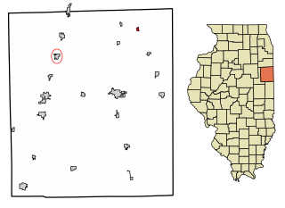
Greenup is a village in Cumberland County, Illinois, United States, along the Embarras River. The population was 1,365 at the 2020 census. It is part of the Charleston–Mattoon Micropolitan Statistical Area.

<span class="mw-page-title-main">Bishop Hill, Illinois</span> Village in Illinois, United States

Bishop Hill is a village in Henry County, Illinois, United States, along the South Edwards River. The population was 128 at the 2010 census, up from 125 in 2000. It is the home of the Bishop Hill State Historic Site, a park operated by the Illinois Historic Preservation Agency.

<span class="mw-page-title-main">Beaverville, Illinois</span> Village in Illinois, United States

Beaverville is a village in Beaverville Township, Iroquois County, Illinois, United States. The population was 362 at the 2010 census.

<span class="mw-page-title-main">Willow Hill, Illinois</span> Village in Illinois, United States

Willow Hill is a village in Jasper County, Illinois. The population was 230 at the 2010 census.

<span class="mw-page-title-main">Lawrenceville, Illinois</span> City in Illinois, United States

Lawrenceville is a city in and the county seat of Lawrence County, Illinois, United States, located along the Embarras River. The population was 4,348 at the 2010 census. Lawrenceville is located in southeast Illinois, northwest of Vincennes, Indiana.

<span class="mw-page-title-main">St. Francisville, Illinois</span> City in Illinois, United States

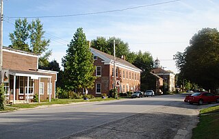
St. Francisville or Saint Francisville is a city in Lawrence County, Illinois, United States. The population was 697 at the 2010 census.

<span class="mw-page-title-main">Madison, Illinois</span> City in Illinois, United States

Madison is a city in Madison and St. Clair counties in the U.S. state of Illinois. The population was 3,171 at the 2020 census, down from 3,891 in 2010. It is home to World Wide Technology Raceway at Gateway and the first Bulgarian Orthodox church in the United States.

<span class="mw-page-title-main">Cahokia, Illinois</span> Village in the United States

Cahokia is a settlement and former village in St. Clair County, Illinois, United States, founded as a colonial French mission in 1689. Located east of the Mississippi River in the Greater St. Louis metropolitan area, as of the 2010 census, 15,241 people lived in the village. On May 6, 2021, the village was incorporated into the new city of Cahokia Heights.

<span class="mw-page-title-main">Lebanon, Illinois</span> City in Illinois, United States

Lebanon is a city in St. Clair County, Illinois, United States. The population was 4,691 at the 2020 census It is a part of the Metro East region of the Greater St. Louis metropolitan area. Lebanon is home to McKendree University, the oldest college in Illinois.

<span class="mw-page-title-main">New Athens, Illinois</span> Village in Illinois, United States

New Athens is a village in St. Clair County, Illinois, United States. Based upon common usage, the 'A' is always sounded with a long vowel, rather than a short vowel, by its residents, unlike the most commonly used English pronunciation of the city in Greece.

<span class="mw-page-title-main">O'Fallon, Illinois</span> City in Illinois, United States

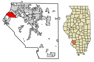
O'Fallon is a city in St. Clair County, Illinois, United States. The 2020 census listed the population at 32,289. The city is the second largest city in the Metro East region of the St. Louis metropolitan area and Southern Illinois. It sits 5 miles (8.0 km) from Scott Air Force Base and 18 miles (29 km) from Downtown St. Louis.

<span class="mw-page-title-main">Shiloh, Illinois</span> Village in Illinois, United States

Shiloh is a village in St. Clair County, Illinois, United States. The 2010 census recorded a population of 12,651. Shiloh is located within the St. Louis metropolitan area

<span class="mw-page-title-main">Zumbrota, Minnesota</span> City in Minnesota, United States

Zumbrota is a city in Goodhue County, Minnesota, United States, along the North Fork of the Zumbro River. The population was 3,252 at the 2010 census. It promotes itself as "the only Zumbrota in the world."

<span class="mw-page-title-main">Ste. Genevieve, Missouri</span> City in Missouri, United States

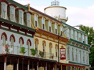
Ste. Genevieve is a city in Ste. Genevieve Township and is the county seat of Ste. Genevieve County, Missouri, United States. The population was 4,999 at the 2020 census. Founded in 1735 by French Canadian colonists and settlers from east of the river, it was the first organized European settlement west of the Mississippi River in present-day Missouri. Today, it is home to Ste. Genevieve National Historical Park, the 422nd unit of the National Park Service.

<span class="mw-page-title-main">Bruce, Wisconsin</span> Village in Wisconsin, United States

Bruce is a village in Rusk County, Wisconsin, United States. The population was 779 at the 2010 census. The village was founded in 1884 by the Sault Ste. Marie Land and Improvement Company. The land company was incorporated and led by the principal officers of the Minneapolis, Sault Ste. Marie and Atlantic Railway, which operated its ceremonial first train over its line to Bruce in November 1884. It was named for Alanson C. Bruce who operated a logging camp in the area.

<span class="mw-page-title-main">Hawkins, Wisconsin</span> Village in Wisconsin, United States

Hawkins is a village in Rusk County in north-central Wisconsin, United States. The population was 305 at the 2010 census. The village is located within the Town of Hawkins.

References

  1. 1 2 3 U.S. Geological Survey Geographic Names Information System: Ste. Marie, Illinois}
  2. "2020 U.S. Gazetteer Files". United States Census Bureau. Retrieved March 15, 2022.
  3. "Geographic Identifiers: 2010 Census Summary File 1 (G001): Ste. Marie village, Illinois". American Factfinder. U.S. Census Bureau. Archived from the original on February 13, 2020. Retrieved May 11, 2018.
  4. "US Gazetteer files: 2010, 2000, and 1990". United States Census Bureau. February 12, 2011. Retrieved April 23, 2011.
  5. "G001 – Geographic Identifiers – 2010 Census Summary File 1". United States Census Bureau. Archived from the original on February 13, 2020. Retrieved December 25, 2015.
  6. "Census of Population and Housing". Census.gov. Retrieved June 4, 2015.
  7. "U.S. Census website". United States Census Bureau . Retrieved January 31, 2008.